
Discover Crete
Discover Crete
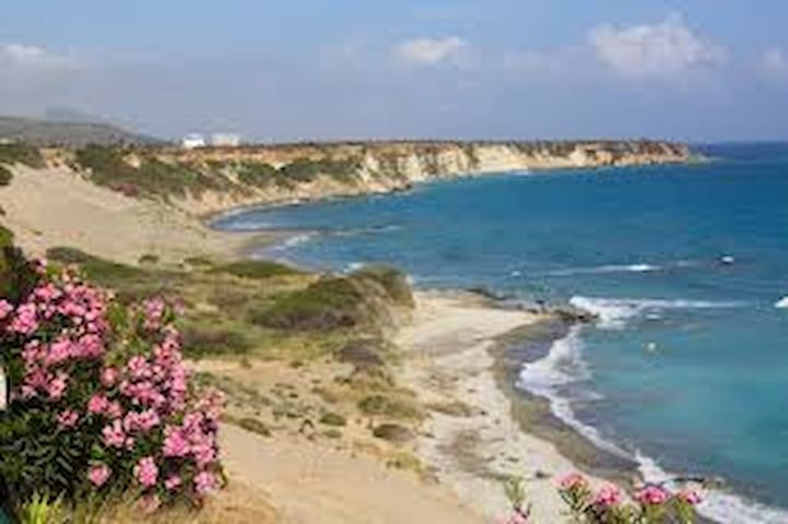
Elafonissi Beach Chania
Elafonissi, located 76km west of Chania is an oblong peninsula, which often breaks in two parts by water, giving the impression of being a separated island. It is a nature 2000 protected area, full of sand dunes with sea daffodils and junipers. The endangered loggerhead sea turtle and several more rare animals and plants find shelter there. It is strictly forbidden to remove any plants, animals, shells and sand from the area. The sand is pinkish in many places, taking its colour from millions of crushed shells and the water is turquoise. Usually crowded but worth visiting. There are some restaurants before reaching it.
1km east is the beautiful Kedrodasos Beach filled with juniper trees and sand dunes.
362 Einheimische empfehlen
Elafonissi Strand
Elafonissi Beach Chania
Elafonissi, located 76km west of Chania is an oblong peninsula, which often breaks in two parts by water, giving the impression of being a separated island. It is a nature 2000 protected area, full of sand dunes with sea daffodils and junipers. The endangered loggerhead sea turtle and several more rare animals and plants find shelter there. It is strictly forbidden to remove any plants, animals, shells and sand from the area. The sand is pinkish in many places, taking its colour from millions of crushed shells and the water is turquoise. Usually crowded but worth visiting. There are some restaurants before reaching it.
1km east is the beautiful Kedrodasos Beach filled with juniper trees and sand dunes.
Balos Lagoon Chania
This famous lagoon is located 56km northwest of Chania, formed between Cape Gramvousa and the small Cape Tigani. It is famous for its turquoise waters, its natural beauty and exotic scenery. The sea is very shallow and warm with pinkish sand in many places, due to millions of crushed shells. Beyond the rocks and boundaries of the lagoon the water is deeper and colder, ideal for snorkeling. It is protected under the Natura 2000 program, with rare species of flora and fauna and shelters the protected monk seal and the loggerhead sea turtle. The easiest and fastest way to get there is by taking the morning ferry from Kissamos. By car, you take the dirt road, starting from Kaliviani, after 10km the road stops at a wide parking area, next to a canteen and then one walks for 1km. Returning back to the parking area is very tiring due the inclination. The third option is trekking for three hours. Best time to be there is early in the morning, before the crowds arrive.
515 Einheimische empfehlen
Balos Strand
Balos Lagoon Chania
This famous lagoon is located 56km northwest of Chania, formed between Cape Gramvousa and the small Cape Tigani. It is famous for its turquoise waters, its natural beauty and exotic scenery. The sea is very shallow and warm with pinkish sand in many places, due to millions of crushed shells. Beyond the rocks and boundaries of the lagoon the water is deeper and colder, ideal for snorkeling. It is protected under the Natura 2000 program, with rare species of flora and fauna and shelters the protected monk seal and the loggerhead sea turtle. The easiest and fastest way to get there is by taking the morning ferry from Kissamos. By car, you take the dirt road, starting from Kaliviani, after 10km the road stops at a wide parking area, next to a canteen and then one walks for 1km. Returning back to the parking area is very tiring due the inclination. The third option is trekking for three hours. Best time to be there is early in the morning, before the crowds arrive.
Orthi Ammos Rethymno
It is a spectacular sandy and shallow beach next to Frangokastelo, Rethymno located 80 km south of Chania, 44 km from Georgioupolis.. It is famous for the big sand hills and dunes and the crystal clear waters. It is affected by south winds but not too much. The east part of the beach is traditionally occupied by nudists, but the number is decreasing in the last years. You can access the beach by either walking 10 minutes from Frangokastelo or park above the sand hill. There are a few accommodations and food amenities, but no sun beds and water sport services. According to the legend, the sand of Orthi Ammos covered the unburied bodies of the 335 Greek heroes that fought against the Ottomans during the Battle of Frangokastelo (17 May, 1828). The spirits of theses heroes are the legendary “Drosoulites”, the famous ghosts of the Frangokastelo fort.
11 Einheimische empfehlen
Orthi Ammos
Orthi Ammos Rethymno
It is a spectacular sandy and shallow beach next to Frangokastelo, Rethymno located 80 km south of Chania, 44 km from Georgioupolis.. It is famous for the big sand hills and dunes and the crystal clear waters. It is affected by south winds but not too much. The east part of the beach is traditionally occupied by nudists, but the number is decreasing in the last years. You can access the beach by either walking 10 minutes from Frangokastelo or park above the sand hill. There are a few accommodations and food amenities, but no sun beds and water sport services. According to the legend, the sand of Orthi Ammos covered the unburied bodies of the 335 Greek heroes that fought against the Ottomans during the Battle of Frangokastelo (17 May, 1828). The spirits of theses heroes are the legendary “Drosoulites”, the famous ghosts of the Frangokastelo fort.
Preveli Palm Beach Rethymno
Lovely Preveli is located 30 km south of Georgioupolis and 10km from Plakias. Preveli beach, is at the exit of the Kourtaliotikos Gorge, where the Grand River flows. It’s famous and during the ‘60s and ‘70s, it was a favorite destination for hippies. On the banks of the Grand River there is a large colony of palm trees, which give the region a sense of a tropical landscape. The river forms a lake, 500m long, that has water all year long. You can walk along the river under the shade of palm and other trees and start ascending the beautiful canyon. You can also swim in the cold ponds formed in the gorge. At the exit of the river, a sandy beach with pebbles and sand is formed, with sea water being very cool due to the river. The beach is not well organized because it is protected, so there are no umbrellas. While in the area visit the Preveli Monastery, founded in the 16th or 17th century. There are two monasteries, the old and the new.
416 Einheimische empfehlen
Preveli Strand
Preveli Palm Beach Rethymno
Lovely Preveli is located 30 km south of Georgioupolis and 10km from Plakias. Preveli beach, is at the exit of the Kourtaliotikos Gorge, where the Grand River flows. It’s famous and during the ‘60s and ‘70s, it was a favorite destination for hippies. On the banks of the Grand River there is a large colony of palm trees, which give the region a sense of a tropical landscape. The river forms a lake, 500m long, that has water all year long. You can walk along the river under the shade of palm and other trees and start ascending the beautiful canyon. You can also swim in the cold ponds formed in the gorge. At the exit of the river, a sandy beach with pebbles and sand is formed, with sea water being very cool due to the river. The beach is not well organized because it is protected, so there are no umbrellas. While in the area visit the Preveli Monastery, founded in the 16th or 17th century. There are two monasteries, the old and the new.
Plakias Beach Rethymno
Plakias is a popular tourist resort, 37km from Georgioupolis by car. The main beach is well organized, with cool green waters. There are tamarisk trees, umbrellas, water sports, beach volleyball courts, changing rooms , showers and snack bars on the beach. Along the beach there is a road for walking and cycling, with restaurants and hotels. The eastern part of the long beach is called Paligremnos which is very sandy and very well organized, next to restaurants and hotels. There are vertical cliffs nearby that rise to a great height which attracts many climbers. There are other smaller beaches around the area.
108 Einheimische empfehlen
Plakias
Plakias Beach Rethymno
Plakias is a popular tourist resort, 37km from Georgioupolis by car. The main beach is well organized, with cool green waters. There are tamarisk trees, umbrellas, water sports, beach volleyball courts, changing rooms , showers and snack bars on the beach. Along the beach there is a road for walking and cycling, with restaurants and hotels. The eastern part of the long beach is called Paligremnos which is very sandy and very well organized, next to restaurants and hotels. There are vertical cliffs nearby that rise to a great height which attracts many climbers. There are other smaller beaches around the area.
Matala Beach Heraklion
Matala is located 68km southwest of Heraklion, where the plain of Messara meets the Asteroussia Mountains. It is one of the most popular destinations, famous for its carved caves in the rocks and the hippies that lived in them in the ‘60s. It is located closed to the ancient city of Phaistos, the second largest palace of the Minoan civilization. Matala served as a port to Phaistos and in the Roman times, it became a port to Gortyn. It is located at the exit of a small valley, which forms an enclosed bay with a nice view to the islands of Paximadia. There is a sandy beach, 300m long, with fine gravel and crystal clear deep water. The seabed is quite rocky in some places, especially in the central part of the beach and waves are common due to frequent west waves. There is a huge cave on the north part of the beach, from the top of which some people dive. Well organized with umbrellas, toilets, showers, lifeguards, first aid, beach volleyball courts, water sports, excursion boats, a camping site and snack bars. A large part of the beach is covered with tamarisk trees. In the evenings, the bars on the beach are full of many people, both locals and foreigners. The internationally renowned Matala Festival takes place in June.
185 Einheimische empfehlen
Matala Caves
Matala Beach Heraklion
Matala is located 68km southwest of Heraklion, where the plain of Messara meets the Asteroussia Mountains. It is one of the most popular destinations, famous for its carved caves in the rocks and the hippies that lived in them in the ‘60s. It is located closed to the ancient city of Phaistos, the second largest palace of the Minoan civilization. Matala served as a port to Phaistos and in the Roman times, it became a port to Gortyn. It is located at the exit of a small valley, which forms an enclosed bay with a nice view to the islands of Paximadia. There is a sandy beach, 300m long, with fine gravel and crystal clear deep water. The seabed is quite rocky in some places, especially in the central part of the beach and waves are common due to frequent west waves. There is a huge cave on the north part of the beach, from the top of which some people dive. Well organized with umbrellas, toilets, showers, lifeguards, first aid, beach volleyball courts, water sports, excursion boats, a camping site and snack bars. A large part of the beach is covered with tamarisk trees. In the evenings, the bars on the beach are full of many people, both locals and foreigners. The internationally renowned Matala Festival takes place in June.
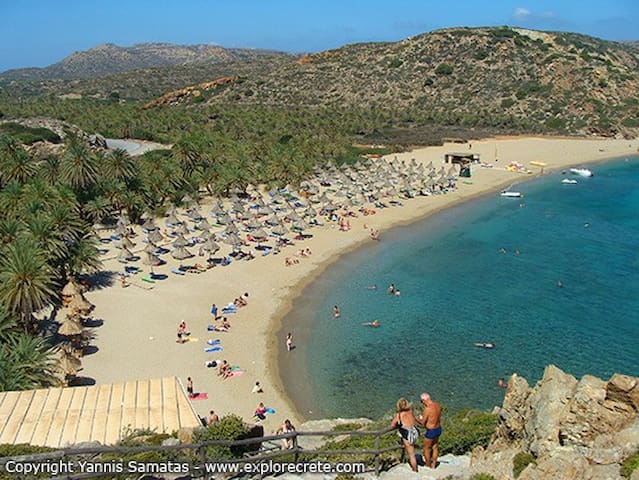
Vai Palm Beach (Finikodassos ) Lasithi
Vai is located 94km east of Agios Nikolaos and 24km east of Sitia. It is the most famous beach in east Crete, as its main feature is the large palm grove with the Cretan Date Palm. It name derives from the word ‘Vai’, which means ‘palm’ in Greek. This palm grove is the largest in Europe with approximately 5000 trees. The palm grove is more than 2000 years old and is planted in a wide valley watered by the local river for centuries. An exotic sandy beach with whitish sand and flat turquoise waters is formed near the shore, backed by the palm tree forest. It is slightly organized, because it is protected, with umbrellas, water sports and a canteen. Rooms to let are located outside the protected area, (15’to 25’ walk) and you have to leave your car in the parking lot. There are other beaches nearby. The entire region is owned by the Toplou Monastery, which is the largest landowner in eastern Crete.
55 Einheimische empfehlen
Vai
Vai Palm Beach (Finikodassos ) Lasithi
Vai is located 94km east of Agios Nikolaos and 24km east of Sitia. It is the most famous beach in east Crete, as its main feature is the large palm grove with the Cretan Date Palm. It name derives from the word ‘Vai’, which means ‘palm’ in Greek. This palm grove is the largest in Europe with approximately 5000 trees. The palm grove is more than 2000 years old and is planted in a wide valley watered by the local river for centuries. An exotic sandy beach with whitish sand and flat turquoise waters is formed near the shore, backed by the palm tree forest. It is slightly organized, because it is protected, with umbrellas, water sports and a canteen. Rooms to let are located outside the protected area, (15’to 25’ walk) and you have to leave your car in the parking lot. There are other beaches nearby. The entire region is owned by the Toplou Monastery, which is the largest landowner in eastern Crete.
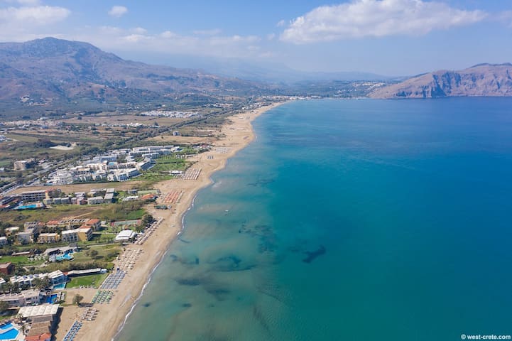
Falassarna Beach Chania
The exotic beach of Falassarna, located 59km west of Chania, spans a large area and actually consists of five consecutive beaches, with the two most central being the most favourite. The sand is whitish, and the water is tropical and turquoise. The main beach is “Pahia Ammos, which means Thich Sand"”, 1 km long, attracts a lot of people but is never crowded. There are sea umbrellas, café’ and snack bars. There are also services for water sports and beach volleyball courts. There is an archaeological site near. Sometimes it gets very windy.
337 Einheimische empfehlen
Falassarna Beach
Falassarna Beach Chania
The exotic beach of Falassarna, located 59km west of Chania, spans a large area and actually consists of five consecutive beaches, with the two most central being the most favourite. The sand is whitish, and the water is tropical and turquoise. The main beach is “Pahia Ammos, which means Thich Sand"”, 1 km long, attracts a lot of people but is never crowded. There are sea umbrellas, café’ and snack bars. There are also services for water sports and beach volleyball courts. There is an archaeological site near. Sometimes it gets very windy.
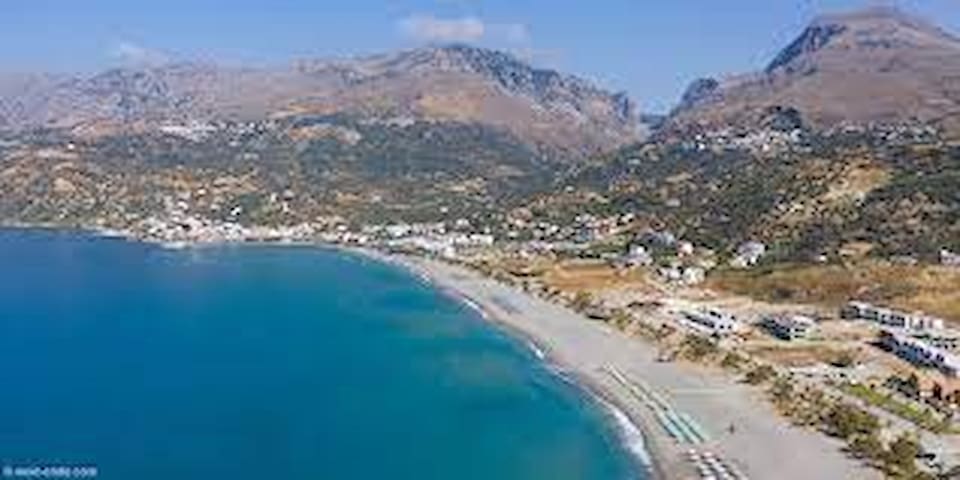
Georgioupoli Beach Chania
It is considered the longest sandy beach on the island.
Situated in the small coastal town of Georgioupolis. It stretches 2 km to the east, starting from the river Almiros and ending in Kavros beach. It is sandy with shallow crystal clear waters. It is well organized with lifeguards Umbrellas, sea beds, food and drinks are available on the beach. Next to the exit of Almiros river lies the small beach of Kalivaki with its cold waters.
140 Einheimische empfehlen
Georgioupoli
Georgioupoli Beach Chania
It is considered the longest sandy beach on the island.
Situated in the small coastal town of Georgioupolis. It stretches 2 km to the east, starting from the river Almiros and ending in Kavros beach. It is sandy with shallow crystal clear waters. It is well organized with lifeguards Umbrellas, sea beds, food and drinks are available on the beach. Next to the exit of Almiros river lies the small beach of Kalivaki with its cold waters.
Gorges
The Samaria Gorge Chania
It is located at the south of the Prefecture of Chania in the larger uninhabited are of Europe where no roads even exist.
It is the most famous trekking gorge in Europe and the part of the European E4 hiking trail. The length of the gorge reaches 14,5km and takes almost 5-7 hours to hike from Xyloskala at the Omalos plateau to the Beach of Agia Roumeli, depending on the trekking pace. There are several endemic species of fauna and flora in the gorge and surrounding and if you are lucky you might see the endangered wild goat of Crete, (Kri-kri). You meet drinking water and toilets very often. The deserted village of Samaria lies just inside the gorge, the last inhabitant abandoned it in 1962.
Visiting Hours: 1st May- 31st October
6 am- 4 pm
https://www.visitgreece.gr/experiences/nature/gorges/samaria-gorge/
517 Einheimische empfehlen
Samaria Gorge
The Samaria Gorge Chania
It is located at the south of the Prefecture of Chania in the larger uninhabited are of Europe where no roads even exist.
It is the most famous trekking gorge in Europe and the part of the European E4 hiking trail. The length of the gorge reaches 14,5km and takes almost 5-7 hours to hike from Xyloskala at the Omalos plateau to the Beach of Agia Roumeli, depending on the trekking pace. There are several endemic species of fauna and flora in the gorge and surrounding and if you are lucky you might see the endangered wild goat of Crete, (Kri-kri). You meet drinking water and toilets very often. The deserted village of Samaria lies just inside the gorge, the last inhabitant abandoned it in 1962.
Visiting Hours: 1st May- 31st October
6 am- 4 pm
https://www.visitgreece.gr/experiences/nature/gorges/samaria-gorge/
The Gorge of Agia Irini Chania
This beautiful gorge is formed at the west side of the White Mountains at the province of Selino. It gets its name after the village Agia Irini (Saint Irene). It is 46km from Chania, its length is 7.5km and it takes about 3 hours to cross. The descent is only 500m. Most of the walk is in the shade so it is suitable for hot days. The gorge ends up in the seaside village of Sougia where you can enjoy swimming in the waters of the South Cretan Sea. The gorge is part of the European footpath E4, it is listed in the Natura 2000 protected areas and it has also been designated as a wildlife reserve. It hosts the endangered Cretan ibex (agrimi, or better known as the Kri-Kri), and is characterized by a variety of microenvironments and habitats for many species of wildlife. There is a big variety in flora from trees (pine, maple, plane, oak and cypress) to shrubs, brushwood and fine herbs such as dittany. At the “Polla Spitakia”, an area inside the gorge, rebels escaped the Ottomans by passing through the path of “Figou” to the escape exit which leads to the plateau of Omalos. The area hosts the Byzantine Church of Christ (1358 AD) and the ruined church of Saint George (1460). The gorge is the second most visited canyon of the Prefecture of Chania after the Samaria Gorge and is open for a longer period.
Open all year round.
https://www.west-crete.com/agia-irini-gorge.htm
13 Einheimische empfehlen
Agia Eirini Gorge
2-6 Theofanous The Gorge of Agia Irini Chania
This beautiful gorge is formed at the west side of the White Mountains at the province of Selino. It gets its name after the village Agia Irini (Saint Irene). It is 46km from Chania, its length is 7.5km and it takes about 3 hours to cross. The descent is only 500m. Most of the walk is in the shade so it is suitable for hot days. The gorge ends up in the seaside village of Sougia where you can enjoy swimming in the waters of the South Cretan Sea. The gorge is part of the European footpath E4, it is listed in the Natura 2000 protected areas and it has also been designated as a wildlife reserve. It hosts the endangered Cretan ibex (agrimi, or better known as the Kri-Kri), and is characterized by a variety of microenvironments and habitats for many species of wildlife. There is a big variety in flora from trees (pine, maple, plane, oak and cypress) to shrubs, brushwood and fine herbs such as dittany. At the “Polla Spitakia”, an area inside the gorge, rebels escaped the Ottomans by passing through the path of “Figou” to the escape exit which leads to the plateau of Omalos. The area hosts the Byzantine Church of Christ (1358 AD) and the ruined church of Saint George (1460). The gorge is the second most visited canyon of the Prefecture of Chania after the Samaria Gorge and is open for a longer period.
Open all year round.
https://www.west-crete.com/agia-irini-gorge.htm
The Gorge of Imbros. Chaniα
The Gorge of Imbros is located in the province of Sfakia and is the third or for some the second most visited gorge in Crete, belonging to the E4hicking path. The length is 11 km and the course lasts 2-3 hours. The route starts from the small village of Imbros, 700 meters above sea level. Follow the sign entrance and soon you will arrive at a ticket counter. The initial part of the gorge, which is quite wide, is called Porofarago or Porolagos, but while descending, the canyon narrows continuously, the sidewalls raise higher and the scenery is impressive. Soon the sides of the canyon start approaching and getting higher. There are various caves, while the vegetation consists of cypresses, oaks and maples popping up through the rocks. The low difficulty makes the descent of Imbros ideal for families and children.
Opening Hours: The Gorge is open all year round.
https://www.west-crete.com/imbros-gorge.htm
23 Einheimische empfehlen
IMBROS GORGE ENTRANCE
Eparchiaki Odos Vruson-Choras SfakionThe Gorge of Imbros. Chaniα
The Gorge of Imbros is located in the province of Sfakia and is the third or for some the second most visited gorge in Crete, belonging to the E4hicking path. The length is 11 km and the course lasts 2-3 hours. The route starts from the small village of Imbros, 700 meters above sea level. Follow the sign entrance and soon you will arrive at a ticket counter. The initial part of the gorge, which is quite wide, is called Porofarago or Porolagos, but while descending, the canyon narrows continuously, the sidewalls raise higher and the scenery is impressive. Soon the sides of the canyon start approaching and getting higher. There are various caves, while the vegetation consists of cypresses, oaks and maples popping up through the rocks. The low difficulty makes the descent of Imbros ideal for families and children.
Opening Hours: The Gorge is open all year round.
https://www.west-crete.com/imbros-gorge.htm
The Aradena Gorge Chania
The deepest gorge in Chania, 138 meter deep, it is ideal not only for sightseeing or hiking, but also for bungee jumping. The trekking inside the canyon till the exit to the majestic Marmara Beach is a unique experience for those who attempt the descent of the canyon. It is one of the longest gorges (15 km long) It starts from the root of the peak Thodoris of the White Mountains and specifically from the underground stream of Cave Drakolakki. The easiest way to reach it is from the Aradena village, at the middle of the gorge’s length. In order to reach it from Chora Sfakion, you walk the carriageway up to the mountain village of Anopoli (12km, at an altitude of 600m), built on the southern side of the foot of the White Mountains. You then walk another 3,5km to reach the village of Aradena, built on the brink of the gorge and deserted after a vendetta. The ancient city of Aradin used to be there .An iron bridge was constructed to unite both sides of the gorge. This is where visitors can do bungee jumping; it is the highest bridge for bungee jumping in Greece and the second in Europe. On the way into the gorge you will meet 9m deep vertical passes where an iron ladder was placed for accommodation purposes. There are very high vertical cliffs, apart from Aradena where you will find old trails to the walls of the gorge. There are also two more abandoned villages on the sides. From the exit of the gorge up to the picturesque village of Loutro the beauty is amazing. There, you will find crafts sailing to Chora Sfakion. If you don’t take the boat, it takes 2 hours to walk from Loutro to Chora Sfakion.
https://www.west-crete.com/aradena-gorge.htm
29 Einheimische empfehlen
Aradena Gorge
The Aradena Gorge Chania
The deepest gorge in Chania, 138 meter deep, it is ideal not only for sightseeing or hiking, but also for bungee jumping. The trekking inside the canyon till the exit to the majestic Marmara Beach is a unique experience for those who attempt the descent of the canyon. It is one of the longest gorges (15 km long) It starts from the root of the peak Thodoris of the White Mountains and specifically from the underground stream of Cave Drakolakki. The easiest way to reach it is from the Aradena village, at the middle of the gorge’s length. In order to reach it from Chora Sfakion, you walk the carriageway up to the mountain village of Anopoli (12km, at an altitude of 600m), built on the southern side of the foot of the White Mountains. You then walk another 3,5km to reach the village of Aradena, built on the brink of the gorge and deserted after a vendetta. The ancient city of Aradin used to be there .An iron bridge was constructed to unite both sides of the gorge. This is where visitors can do bungee jumping; it is the highest bridge for bungee jumping in Greece and the second in Europe. On the way into the gorge you will meet 9m deep vertical passes where an iron ladder was placed for accommodation purposes. There are very high vertical cliffs, apart from Aradena where you will find old trails to the walls of the gorge. There are also two more abandoned villages on the sides. From the exit of the gorge up to the picturesque village of Loutro the beauty is amazing. There, you will find crafts sailing to Chora Sfakion. If you don’t take the boat, it takes 2 hours to walk from Loutro to Chora Sfakion.
https://www.west-crete.com/aradena-gorge.htm
The kourtaliotiko Gorge Rethymno
Among the most beautiful natural wonders of southern Crete is the Kourtaliotikos Gorge, a wild and breathtaking destination with waterfalls, fountains, deserted chapels and monasteries. It is located in the central part of the southern coast of Crete about 25km south of Rethymno and is 3km long. Starting south of the village Koxare, Rethymno, it leads south where one passes through a plain and continues with the small gorge of Preveli, then reaching the breathtaking palm beach of Preveli.
Best way to get there is by car. From the village Koxare you can drive through the canyon, or if you prefer, you can walk. It is more difficult to get there by bus, as you have to change buses at Rethymno and it could take some hours to get to Koxare. Endangered birds like vultures, griffon vultures, the Golden Eagle have found shelter at this Gorge. It also has ecological and biological value since besides the clusters of Cretan Date Palm Trees, there is rich vegetation, sand dunes and the plant Posidonia. As for animals, you can find the tortoise (auremys casoica) and the local fresh water snake (Elaphe situla).
https://www.cretanbeaches.com/en/gorges-and-canyons-in-crete/rethymnon-gorges/kourtaliotis-gorge

Kourtaliotiko Gorge Waterfalls
The kourtaliotiko Gorge Rethymno
Among the most beautiful natural wonders of southern Crete is the Kourtaliotikos Gorge, a wild and breathtaking destination with waterfalls, fountains, deserted chapels and monasteries. It is located in the central part of the southern coast of Crete about 25km south of Rethymno and is 3km long. Starting south of the village Koxare, Rethymno, it leads south where one passes through a plain and continues with the small gorge of Preveli, then reaching the breathtaking palm beach of Preveli.
Best way to get there is by car. From the village Koxare you can drive through the canyon, or if you prefer, you can walk. It is more difficult to get there by bus, as you have to change buses at Rethymno and it could take some hours to get to Koxare. Endangered birds like vultures, griffon vultures, the Golden Eagle have found shelter at this Gorge. It also has ecological and biological value since besides the clusters of Cretan Date Palm Trees, there is rich vegetation, sand dunes and the plant Posidonia. As for animals, you can find the tortoise (auremys casoica) and the local fresh water snake (Elaphe situla).
https://www.cretanbeaches.com/en/gorges-and-canyons-in-crete/rethymnon-gorges/kourtaliotis-gorge
Monasteries of Crete
Governetos Monastery Chania
The Governetos Monastery is one of Crete’s oldest monasteries, founded in 1537. The Gouvernetos Monastery, also known as Our Lady of the Angels, is located on the Akrotiri Peninsula, about 4 kilometers from the Monastery of Agia Triada and 19 kilometers north of Chania. The Gouvernetos Monastery is built in the style of a castle, with high towers nestled to protect it against invaders. The monastery’s exterior, in particular, exhibits considerable Venetian influences: it is 40 m x 50 m in size, with around 50 monks’ cells on two levels. There is also a tower in each of the four corners and distinctive embrasures or apertures in the walls. Only two of the towers exist now, although the remnants of the other two may be seen from the courtyard.
There are two small astonishing chapels on either side of the main church. The first one is dedicated to the Ten Saints of Crete, while the other is for Saint John the Hermit. Saint John not only founded the monastery, but he also lived in the nearby cave known as Arkoudospilios. The cave is right below the monastery, along the Avlaki Gorge.
• Region: 19 km north of Chania
• Opening Hours:
Monday, Tuesday, and Thursday: 9 am – 12 pm / 5 pm – 7 pm
Saturday and Sunday: 9 am – 11 am / 5 pm – 8 pm
• Entrance Tickets: Free
• https://mapcarta.com/N305276234
56 Einheimische empfehlen
Kloster Gouverneto
Governetos Monastery Chania
The Governetos Monastery is one of Crete’s oldest monasteries, founded in 1537. The Gouvernetos Monastery, also known as Our Lady of the Angels, is located on the Akrotiri Peninsula, about 4 kilometers from the Monastery of Agia Triada and 19 kilometers north of Chania. The Gouvernetos Monastery is built in the style of a castle, with high towers nestled to protect it against invaders. The monastery’s exterior, in particular, exhibits considerable Venetian influences: it is 40 m x 50 m in size, with around 50 monks’ cells on two levels. There is also a tower in each of the four corners and distinctive embrasures or apertures in the walls. Only two of the towers exist now, although the remnants of the other two may be seen from the courtyard.
There are two small astonishing chapels on either side of the main church. The first one is dedicated to the Ten Saints of Crete, while the other is for Saint John the Hermit. Saint John not only founded the monastery, but he also lived in the nearby cave known as Arkoudospilios. The cave is right below the monastery, along the Avlaki Gorge.
• Region: 19 km north of Chania
• Opening Hours:
Monday, Tuesday, and Thursday: 9 am – 12 pm / 5 pm – 7 pm
Saturday and Sunday: 9 am – 11 am / 5 pm – 8 pm
• Entrance Tickets: Free
• https://mapcarta.com/N305276234
Agia Triada Monastery Chania
Agia Triada, which means “Holy Trinity”, is found in Chania .The monastery was built in the 17th century by two brothers who came from the Venetian Zangaroli family, during the last years of the Venetian rule. The monastery’s architectural design was created by one of the founders, Jeremias, and was finished by his brother after his death. It is square in form and encircled by strong defensive walls. After climbing the formidable steps at the entryway, a vaulted passage leads to a magnificent courtyard with lavish fruit trees and gorgeous flowers, a landscape meticulously maintained by the monastery’s monks. There are two chapels found in the area. One of them is in honor of Saint John the Theologian. It also boasts a distinctive dome with beautiful paintings on the inside. The bell tower is situated directly across from the church and beneath the entryway. You can also see a museum and library, all showcasing various artifacts from the monastery’s history. If you wish, you may explore the wine cellars, an antique stone mill, and many artifacts from the monastery’s past in the building next to the monastery. You can also sample the monastery’s wines and olive oil, as well as other gourmet specialties, such as their orange balsamic sauce.
• Region: Chania
Opening Hours:
Summer: 8 am – 5 pm
Entrance Tickets: €2.50, free for children and local citizens.
https://mapcarta.com/W582642712
67 Einheimische empfehlen
Kloster Agia Triada
Ακροτήρι Agia Triada Monastery Chania
Agia Triada, which means “Holy Trinity”, is found in Chania .The monastery was built in the 17th century by two brothers who came from the Venetian Zangaroli family, during the last years of the Venetian rule. The monastery’s architectural design was created by one of the founders, Jeremias, and was finished by his brother after his death. It is square in form and encircled by strong defensive walls. After climbing the formidable steps at the entryway, a vaulted passage leads to a magnificent courtyard with lavish fruit trees and gorgeous flowers, a landscape meticulously maintained by the monastery’s monks. There are two chapels found in the area. One of them is in honor of Saint John the Theologian. It also boasts a distinctive dome with beautiful paintings on the inside. The bell tower is situated directly across from the church and beneath the entryway. You can also see a museum and library, all showcasing various artifacts from the monastery’s history. If you wish, you may explore the wine cellars, an antique stone mill, and many artifacts from the monastery’s past in the building next to the monastery. You can also sample the monastery’s wines and olive oil, as well as other gourmet specialties, such as their orange balsamic sauce.
• Region: Chania
Opening Hours:
Summer: 8 am – 5 pm
Entrance Tickets: €2.50, free for children and local citizens.
https://mapcarta.com/W582642712
The Prodromou Monastery of Korakies Chania
A beautiful monastery located near the mentioned monasteries above. It’s a typical Orthodox Easter gathering spot, where the monastery’s nuns take turns reading the Holy Scripts in many languages all throughout the night. In fact, residents of the Akrotiri peninsula claim this is the most traditional Easter destination in Chania. So if you happen to be in Crete during Easter this is a must-visit monastery. The monastery’s official name is Holy Convent of Saint John the Forerunner. Unfortunately, its founding date is uncertain because the convent’s documents were lost during consecutive Ottoman raids. The convent was heavily destroyed after the Greek revolt against the Ottomans in 1821. The nuns sought safety in other religious structures in the area. In 1867, the monastery reopened, while several of the nuns were involved in many of the Cretan fights against the Turks.
Today, visitors may tour the Korakies monastery and stroll through the beautiful gardens, while learning about historical crafts in the museum. The monastery is home to only a few nuns, who are exceptionally accommodating to foreigners and anyone interested in learning more about the history of Korakies Monastery.
• Opening Hours: 8 am – 6 pm
• Entrance Tickets: Free
• Map: https://mapcarta.com/W556021532
Monastery of St. John the Baptist
KaraiskakiThe Prodromou Monastery of Korakies Chania
A beautiful monastery located near the mentioned monasteries above. It’s a typical Orthodox Easter gathering spot, where the monastery’s nuns take turns reading the Holy Scripts in many languages all throughout the night. In fact, residents of the Akrotiri peninsula claim this is the most traditional Easter destination in Chania. So if you happen to be in Crete during Easter this is a must-visit monastery. The monastery’s official name is Holy Convent of Saint John the Forerunner. Unfortunately, its founding date is uncertain because the convent’s documents were lost during consecutive Ottoman raids. The convent was heavily destroyed after the Greek revolt against the Ottomans in 1821. The nuns sought safety in other religious structures in the area. In 1867, the monastery reopened, while several of the nuns were involved in many of the Cretan fights against the Turks.
Today, visitors may tour the Korakies monastery and stroll through the beautiful gardens, while learning about historical crafts in the museum. The monastery is home to only a few nuns, who are exceptionally accommodating to foreigners and anyone interested in learning more about the history of Korakies Monastery.
• Opening Hours: 8 am – 6 pm
• Entrance Tickets: Free
• Map: https://mapcarta.com/W556021532
The Convent of Chrysopigi Chania
The Convent of Chrysopigi, just outside the city of Chania, is dedicated to Mother Mary, the Life-Giving Font (Panagia Zoodochos Pigi). The convent was built like a fortress, in the 16th century and was founded as a monastery by Ioannis Chartophylakas. During Venetian rule, it was a significant spiritual center with a well-stocked library. It started to decline during the Ottoman siege in the summer of 1645, when Philotheos Skoufos, the Father Superior, escaped to the Ionian Islands.
Since then the monastery had been deserted until it was restored in the 18th century. During the Liberation Revolution against the Ottomans, it was burnt down and after 1830 it played an important ecclesiastical role. Then, during the Second World War, the Nazi soldiers forced the monks to leave and caused serious damage to the building. In 1976 Chrysopigi was restored and became a convent. The interior of the church, dedicated to the Life-giving Font (Zoodochos Pigi), is decorated with wonderful icons of the 19th century and a wonderfully carved wooden iconostasis.
Nearby the monastery, we find The Ecclesiastical Museum of the Monastery of Chrysopigi and the Folklore Museum of Monastery of Chrysopigi. Here the visitor will find a display of ecclesiastical items and icons from the 15th, 16th and 17th century along with holy utensils and old handwritten books. The monastery is located only 4 km from the center of Chania and is easily accessible. Since 1976 the monastery operates as a nunnery. The nearby monastery of Agia Kyriaki became a dependency of Chrysopigi in 1673. Agia Kyriaki suffered a similar fate during the war and was restored in 1993. The monastery is an active and vibrant center; the nuns are involved in restoration work and also cultivate 130 acres of land. Visitors can buy organic olive oil made on site and there are also educational programs that take place here to educate children about organic farming. There is no entrance fee to visit the monastery.
*Please keep in mind that you will have to cover your shoulders and legs to enter the monastery. Swimsuits, tank tops and shorts, or short skirts are not allowed. A loose scarf or towel can be used to cover up.
he monastery is open to pilgrims daily (8.00am - 12.00pm and 3.30pm - 6.00pm). Pilgrims who wish to, participate in the monastic liturgical program of daily ceremonies. Divine Liturgy is held every Saturday and Sunday and on the great feasts.
website: www.imx.gr
https://mapcarta.com/N5722340612
12 Einheimische empfehlen
Chryssopigi Monastery
Patriarchoi VartholomaioiThe Convent of Chrysopigi Chania
The Convent of Chrysopigi, just outside the city of Chania, is dedicated to Mother Mary, the Life-Giving Font (Panagia Zoodochos Pigi). The convent was built like a fortress, in the 16th century and was founded as a monastery by Ioannis Chartophylakas. During Venetian rule, it was a significant spiritual center with a well-stocked library. It started to decline during the Ottoman siege in the summer of 1645, when Philotheos Skoufos, the Father Superior, escaped to the Ionian Islands.
Since then the monastery had been deserted until it was restored in the 18th century. During the Liberation Revolution against the Ottomans, it was burnt down and after 1830 it played an important ecclesiastical role. Then, during the Second World War, the Nazi soldiers forced the monks to leave and caused serious damage to the building. In 1976 Chrysopigi was restored and became a convent. The interior of the church, dedicated to the Life-giving Font (Zoodochos Pigi), is decorated with wonderful icons of the 19th century and a wonderfully carved wooden iconostasis.
Nearby the monastery, we find The Ecclesiastical Museum of the Monastery of Chrysopigi and the Folklore Museum of Monastery of Chrysopigi. Here the visitor will find a display of ecclesiastical items and icons from the 15th, 16th and 17th century along with holy utensils and old handwritten books. The monastery is located only 4 km from the center of Chania and is easily accessible. Since 1976 the monastery operates as a nunnery. The nearby monastery of Agia Kyriaki became a dependency of Chrysopigi in 1673. Agia Kyriaki suffered a similar fate during the war and was restored in 1993. The monastery is an active and vibrant center; the nuns are involved in restoration work and also cultivate 130 acres of land. Visitors can buy organic olive oil made on site and there are also educational programs that take place here to educate children about organic farming. There is no entrance fee to visit the monastery.
*Please keep in mind that you will have to cover your shoulders and legs to enter the monastery. Swimsuits, tank tops and shorts, or short skirts are not allowed. A loose scarf or towel can be used to cover up.
he monastery is open to pilgrims daily (8.00am - 12.00pm and 3.30pm - 6.00pm). Pilgrims who wish to, participate in the monastic liturgical program of daily ceremonies. Divine Liturgy is held every Saturday and Sunday and on the great feasts.
website: www.imx.gr
https://mapcarta.com/N5722340612
The Monastery of Gonia Odigitria Chania
This easy-to-find monastery of Our Lady of Gonia is located at the base of Cape Rodopo. It is less than 1 km from the village of Kolimvari and 25 kilometers from the heart of Chania. It’s in a spectacular high site, on a steep hill overlooking the Gulf of Chania. The views of this monastery are enough to take your breath away. The monastery was first established in the 9th century and was located farther within the peninsula, near the beach of Menies and not far from the historic remnants of a Minoan temple. However, it was rebuilt in its current position during the 15th century, under the control of the Republic of Venice. As a result, Venetian architecture has had a great influence on the construction of the monastery.
The building has fortified walls with a beautiful courtyard facing the church and the cells of the monks. There is also a belfry and a gorgeous fountain found at the entrance. During the Ottoman rule, Gonia, like many other Cretan monasteries, was subjected to repeated attacks and efforts of demolition; in fact, you can still see the remains of an old cannonball on one of the monastery’s walls.
• Opening Hours: 9 am – 1 pm / 2 pm – 7 pm
• Entrance Tickets: €2.00
Map: https://mapcarta.com/12858372
30 Einheimische empfehlen
Kloster Gonia Odigitria
The Monastery of Gonia Odigitria Chania
This easy-to-find monastery of Our Lady of Gonia is located at the base of Cape Rodopo. It is less than 1 km from the village of Kolimvari and 25 kilometers from the heart of Chania. It’s in a spectacular high site, on a steep hill overlooking the Gulf of Chania. The views of this monastery are enough to take your breath away. The monastery was first established in the 9th century and was located farther within the peninsula, near the beach of Menies and not far from the historic remnants of a Minoan temple. However, it was rebuilt in its current position during the 15th century, under the control of the Republic of Venice. As a result, Venetian architecture has had a great influence on the construction of the monastery.
The building has fortified walls with a beautiful courtyard facing the church and the cells of the monks. There is also a belfry and a gorgeous fountain found at the entrance. During the Ottoman rule, Gonia, like many other Cretan monasteries, was subjected to repeated attacks and efforts of demolition; in fact, you can still see the remains of an old cannonball on one of the monastery’s walls.
• Opening Hours: 9 am – 1 pm / 2 pm – 7 pm
• Entrance Tickets: €2.00
Map: https://mapcarta.com/12858372
The Arkadi Monastery Rethymno
The Arkadi Monastery is a site of exceptional historical importance, recognized for the events that occurred during the 1866 revolt. The monastery is situated on the edge of a high plateau. Arkadi is one of the most prominent monuments in Crete and a popular tourist destination. The first fortressing part of the monastery is said to have been built in the 12th century by an Arkadian monk. During the Ottoman invasion, the monks escaped after the Turks raided Arkadi. They were permitted to return and reconstruct the destroyed structures after months of negotiating and vowing fealty to the authorities. Around 100 monks lived within the vicinity and over 200 more in the neighboring districts. The monks farmed the area and produced wine and olive oil, making it Crete’s most opulent monastery. Defensive walls surrounded it, giving it the impression of being a fortress. The church, right in the center of the courtyard, is filled with many valuable icons. The paintings were made during the Cretan renaissance period. In addition, a museum is located in the monastery, providing visitors with a further understanding of Arkadi’s history. It includes a collection of documents and Cretan folk art items. You can also see an ossuary right outside the Arkadi monastery, housing the remains of monks who once lived there.
• Opening Hours:
Summer: 9 am – 6 pm
• Entrance Tickets: €3.00
• https://www.arkadimonastery.gr/home.html
https://mapcarta.com/12874964
178 Einheimische empfehlen
Monastery of Arkadi
The Arkadi Monastery Rethymno
The Arkadi Monastery is a site of exceptional historical importance, recognized for the events that occurred during the 1866 revolt. The monastery is situated on the edge of a high plateau. Arkadi is one of the most prominent monuments in Crete and a popular tourist destination. The first fortressing part of the monastery is said to have been built in the 12th century by an Arkadian monk. During the Ottoman invasion, the monks escaped after the Turks raided Arkadi. They were permitted to return and reconstruct the destroyed structures after months of negotiating and vowing fealty to the authorities. Around 100 monks lived within the vicinity and over 200 more in the neighboring districts. The monks farmed the area and produced wine and olive oil, making it Crete’s most opulent monastery. Defensive walls surrounded it, giving it the impression of being a fortress. The church, right in the center of the courtyard, is filled with many valuable icons. The paintings were made during the Cretan renaissance period. In addition, a museum is located in the monastery, providing visitors with a further understanding of Arkadi’s history. It includes a collection of documents and Cretan folk art items. You can also see an ossuary right outside the Arkadi monastery, housing the remains of monks who once lived there.
• Opening Hours:
Summer: 9 am – 6 pm
• Entrance Tickets: €3.00
• https://www.arkadimonastery.gr/home.html
https://mapcarta.com/12874964
The Monastery of Preveli Rethymno
One of the must-visit monasteries in Crete is the Preveli Monastery. Surrounded by mountains and a great view of the sea, the Preveli Monastery is an ancient monastery that was believed to have been established during the Venetian period (1205-1669). The monastery is made up of two major building complexes: the first one is the Lower (Kato) Monastery of Saint John the Baptist. The second one is the Rear (Pisso) Monastery of Saint John the Theologian, both of which are still in use today. The monastery has a glorious history due to its fellow monks’ strong and leading involvement in all national endeavours for the independence and education of their people. As a result, this monastery is respected and well-known as a major influence in the public life of Crete.
In 1649, the Turks invaded Crete and destroyed numerous church establishments, including the Preveli Monastery. For three centuries, the monastery was regarded as the most important center due to its high position in the local society of Sfakia and Saint Vassilios provinces, where the Turkish invasion force permitted a distinctive system of political tolerance and a restricted state of freedom due to the landscaping territory. Today, the monastery is a major tourist attraction in Crete. The Lower Monastery has various structures as well as a courtyard. The church of Saint John is located in the center of the yard. The Lower Monastery’s church (Katholikon) includes one aisle, a domed roof, and a tower with two huge bells.
On the other hand, the Rear Monastery is situated at the base of a mountain facing the sea. There is a small cemetery with a beautiful chapel and a burial chamber for the monks. The church (Katholikon) is located in the center of the courtyard and has a lovely yet simple exterior.
• Opening Hours:
Summer: 9 am – 6 pm
• Entrance Tickets: €2.50, free for local citizens.
• https://mapcarta.com/W545540095
99 Einheimische empfehlen
Preveli Monastery
The Monastery of Preveli Rethymno
One of the must-visit monasteries in Crete is the Preveli Monastery. Surrounded by mountains and a great view of the sea, the Preveli Monastery is an ancient monastery that was believed to have been established during the Venetian period (1205-1669). The monastery is made up of two major building complexes: the first one is the Lower (Kato) Monastery of Saint John the Baptist. The second one is the Rear (Pisso) Monastery of Saint John the Theologian, both of which are still in use today. The monastery has a glorious history due to its fellow monks’ strong and leading involvement in all national endeavours for the independence and education of their people. As a result, this monastery is respected and well-known as a major influence in the public life of Crete.
In 1649, the Turks invaded Crete and destroyed numerous church establishments, including the Preveli Monastery. For three centuries, the monastery was regarded as the most important center due to its high position in the local society of Sfakia and Saint Vassilios provinces, where the Turkish invasion force permitted a distinctive system of political tolerance and a restricted state of freedom due to the landscaping territory. Today, the monastery is a major tourist attraction in Crete. The Lower Monastery has various structures as well as a courtyard. The church of Saint John is located in the center of the yard. The Lower Monastery’s church (Katholikon) includes one aisle, a domed roof, and a tower with two huge bells.
On the other hand, the Rear Monastery is situated at the base of a mountain facing the sea. There is a small cemetery with a beautiful chapel and a burial chamber for the monks. The church (Katholikon) is located in the center of the courtyard and has a lovely yet simple exterior.
• Opening Hours:
Summer: 9 am – 6 pm
• Entrance Tickets: €2.50, free for local citizens.
• https://mapcarta.com/W545540095
Toplou Monastery Lasithi
Another historical monastery in Crete is the Toplou Monastery. It was built in the 15th century and is located in the eastern part of the island on the way to the Beach of Vai. The monastery is guarded with a 10m high defensive wall, which kept enemy raids at bay. It’s a three-storey structure with a square area of 800 sq m. You can also find 40 rooms and a 33m high bell tower in the area. The Toplou Monastery was initially called Panagia Akrotiriani, which means Virgin Mary of the cape. However, during the Turkish period, the name was changed to Toplou since “top” means cannon, and a cannon was stationed in the monastery as a line of defense. Throughout the years, the monastery has changed ownership multiple times, but it continued to be of religious significance.
Today, visitors can access the on-site museum to examine the many things that the monastery utilized to fight the Germans. Among them is a wireless radio that is used to connect with allied troops in Egypt. Unfortunately, when German forces discovered the so-called radio, it led to the torture and killing of the abbot and many monks (in the jail of Agia, near Chania).
• Opening Hours:
9 am-1 pm / 2 pm-6 pm – Toplou Monastery is open all year around
• Entrance Tickets: €2.50
• https://mapcarta.com/12851332
61 Einheimische empfehlen
Kloster Toplou
Toplou Monastery Lasithi
Another historical monastery in Crete is the Toplou Monastery. It was built in the 15th century and is located in the eastern part of the island on the way to the Beach of Vai. The monastery is guarded with a 10m high defensive wall, which kept enemy raids at bay. It’s a three-storey structure with a square area of 800 sq m. You can also find 40 rooms and a 33m high bell tower in the area. The Toplou Monastery was initially called Panagia Akrotiriani, which means Virgin Mary of the cape. However, during the Turkish period, the name was changed to Toplou since “top” means cannon, and a cannon was stationed in the monastery as a line of defense. Throughout the years, the monastery has changed ownership multiple times, but it continued to be of religious significance.
Today, visitors can access the on-site museum to examine the many things that the monastery utilized to fight the Germans. Among them is a wireless radio that is used to connect with allied troops in Egypt. Unfortunately, when German forces discovered the so-called radio, it led to the torture and killing of the abbot and many monks (in the jail of Agia, near Chania).
• Opening Hours:
9 am-1 pm / 2 pm-6 pm – Toplou Monastery is open all year around
• Entrance Tickets: €2.50
• https://mapcarta.com/12851332
Paths of Apokoronas
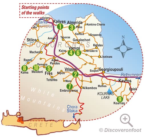
Apokoronos
Discover Apokoronas on foot!
12 routes
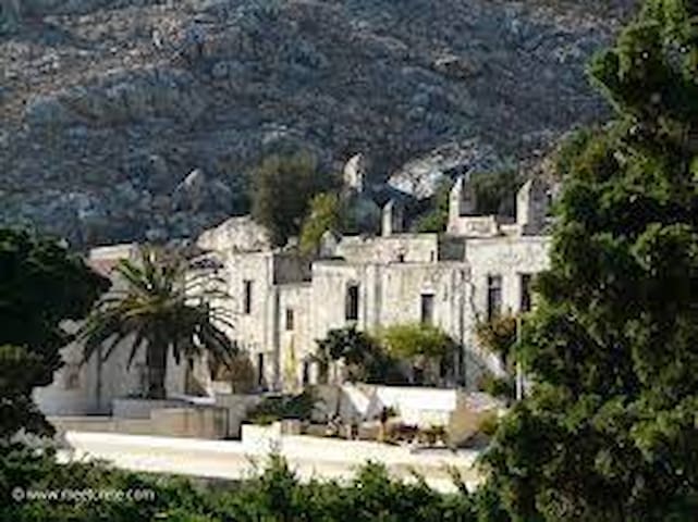
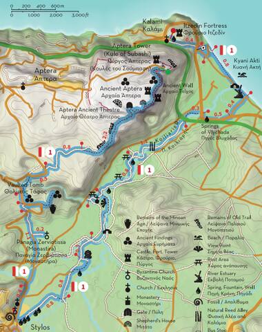
ROUTE 1 Part1“Aptera, between water and air”
PART A
Kalami - Itzedin Fortress - Kyani Akti - Vlychada Springs - Platanakia - Kalogeri watermill- Stilos
This route is one of the two that connect the Municipalities of Chania and Apokoronas, passing through significant monuments, combining elements of history and culture with impressive alternations of the landscape. The starting point of this route is the settlement of Kalami at the western end of the former province of Apokoronas, which is part of the Municipality of Chania since 2010. Acknowledging the strategic location of the site, Rauf Pasha ordered the construction of Itzedin Fortress in 1870, named after Prince Yusuf Izzeddin efendi, the eldest son of Sultan Abdulaziz. The path passes south of Itzedin Fortress and meets the old national road after 0.4 km. From here, turn left (to the east) towards Kyani Akti, one of the largest and cleanest shores of Apokoronas, which you will reach after 800 meters.
Continuing along the coast (to the east), you will cross over a bridge that spans Kiliaris river, which meets the Gulf of Souda a few meters down the stream. About 200 meters after this bridge, turn right (southwest) on the first junction you will meet and again right (west) once you reach the old highway, 400 meters away. Follow this road until the next bridge, cross over it and turn immediately after it to the left (west), following a curvy dirt road that follows the west bank of Kiliaris river all the way to Stylos (note you should be walking against the flow). About 2.3 km up this road you will reach the small chapel of Agios Ioannis Rigologos at Platanakia. On your way, you should find two rest areas and two springs with fresh, clean water to refuel.
From Platanakia head back to the river and continue along it (to the south), passing by (but not over) an old bridge and continue straight on the next junction which has a Ψ shape (Depending on the time of the year there might be water flowing on the road. If so, walk carefully). Once you pass the creek continue straight until the next junction for 300 meters and then turn left (southwest), looking for the old Venetian watermill of Stylos, also known as the Monks’ Mill (Milos ton kalogeron). From here follow the signs to Stylos, which is only 1.5 km away (to the southwest). At the northern entrance of the village you will find the interesting church of Agios Ioannis Theologos and Agios Nikolaos, built in the 13th century, inside which excavations have revealed the traces of an older one dating back to the 7th or 8th century. Continuing on to the center of the village you will meet the famous springs (pigés) of Stilos, where you can rest or resupply and continue on Part B of Route 1, heading towards ancient Aptera.
ATTENTION: Please note that the construction of the trails is in progress and the paths will not be accessible and completely safe until the delivery of the project in the summer of 2022.
Total length of Part A: 7.5 km, estimated time 2h 25΄
Total length of Route 1: 12.8 km, estimated time 4h 15΄
Address: https://scontent.fath7-1.fna.fbcdn.net/v/t39.30808-6/250276772_4409116075803469_2920719208969486218_n.png?stp=dst-png_s600x600&_nc_cat=104&ccb=1-6&_nc_sid=730e14&_nc_ohc=-x0PjTV3JB8AX8bk_vh&_nc_ht=scontent.fath7-1.fna&oh=00_AT_jx-xpJnyhWzwNEnf9h7N69KsXhP5plrZNaJwPL5iebw&oe=627E1901
21 Einheimische empfehlen

Apokoronos
ROUTE 1 Part1“Aptera, between water and air”
PART A
Kalami - Itzedin Fortress - Kyani Akti - Vlychada Springs - Platanakia - Kalogeri watermill- Stilos
This route is one of the two that connect the Municipalities of Chania and Apokoronas, passing through significant monuments, combining elements of history and culture with impressive alternations of the landscape. The starting point of this route is the settlement of Kalami at the western end of the former province of Apokoronas, which is part of the Municipality of Chania since 2010. Acknowledging the strategic location of the site, Rauf Pasha ordered the construction of Itzedin Fortress in 1870, named after Prince Yusuf Izzeddin efendi, the eldest son of Sultan Abdulaziz. The path passes south of Itzedin Fortress and meets the old national road after 0.4 km. From here, turn left (to the east) towards Kyani Akti, one of the largest and cleanest shores of Apokoronas, which you will reach after 800 meters.
Continuing along the coast (to the east), you will cross over a bridge that spans Kiliaris river, which meets the Gulf of Souda a few meters down the stream. About 200 meters after this bridge, turn right (southwest) on the first junction you will meet and again right (west) once you reach the old highway, 400 meters away. Follow this road until the next bridge, cross over it and turn immediately after it to the left (west), following a curvy dirt road that follows the west bank of Kiliaris river all the way to Stylos (note you should be walking against the flow). About 2.3 km up this road you will reach the small chapel of Agios Ioannis Rigologos at Platanakia. On your way, you should find two rest areas and two springs with fresh, clean water to refuel.
From Platanakia head back to the river and continue along it (to the south), passing by (but not over) an old bridge and continue straight on the next junction which has a Ψ shape (Depending on the time of the year there might be water flowing on the road. If so, walk carefully). Once you pass the creek continue straight until the next junction for 300 meters and then turn left (southwest), looking for the old Venetian watermill of Stylos, also known as the Monks’ Mill (Milos ton kalogeron). From here follow the signs to Stylos, which is only 1.5 km away (to the southwest). At the northern entrance of the village you will find the interesting church of Agios Ioannis Theologos and Agios Nikolaos, built in the 13th century, inside which excavations have revealed the traces of an older one dating back to the 7th or 8th century. Continuing on to the center of the village you will meet the famous springs (pigés) of Stilos, where you can rest or resupply and continue on Part B of Route 1, heading towards ancient Aptera.
ATTENTION: Please note that the construction of the trails is in progress and the paths will not be accessible and completely safe until the delivery of the project in the summer of 2022.
Total length of Part A: 7.5 km, estimated time 2h 25΄
Total length of Route 1: 12.8 km, estimated time 4h 15΄
Address: https://scontent.fath7-1.fna.fbcdn.net/v/t39.30808-6/250276772_4409116075803469_2920719208969486218_n.png?stp=dst-png_s600x600&_nc_cat=104&ccb=1-6&_nc_sid=730e14&_nc_ohc=-x0PjTV3JB8AX8bk_vh&_nc_ht=scontent.fath7-1.fna&oh=00_AT_jx-xpJnyhWzwNEnf9h7N69KsXhP5plrZNaJwPL5iebw&oe=627E1901
ROUTE 1 Part2 “Aptera, between water and air”
PART B
Stylos - Panagia Zerviotissa - Minoan tomb of Azogyre - Aptera - Subashi Tower
Starting from Stylos (or continuing from Part A), head north along the asphalt road to Aptera - Megala Chorafia. About 450 meters after the factory of ET.AN.AP and the church of Agios Ioannis the Theologian and Agios Nikolaos (on your left as you exit the village), turn right (northeast) on a dirt road. After walking for about 270 meters on it you will meet a fork, follow its left branch, cross the stream and continue straight at the next crossroads. About 400 meters away turn right (to the east), in order to visit the church of Panagia Zerviotissa, which was named so because Virgin Mary is depicted holding Christ on her left side (zervá is left in the Cretan dialect). The church was built in the 10th century and is also known as Monastira, due to its impressive size.
Return to the main path the same way (for about 200 meters) and turn right (north) towards Aptera. When you meet the asphalt road, cross over it and continue opposite on a dirt road (for 140 meters), turning left (north) at its end. About 140 meters further on this road turn right for another detour, which will lead you to a Minoan vaulted tomb at a location named Azogyre(s). Excavations that have taken place on the hill further east revealed the remains of a Minoan settlement which used to control the western side of the Kiliaris valley, but was abandoned during the Late Minoan period (1560-1050 BC).
Return to the road and turn right (east) after about half a kilometer, following a dirt road that narrows into a path after 800 meters. This path leads after about 1 km to the south gate of the ancient city of Aptera, which was founded during the late Geometric years (760-700 BC) and flourished during the Classical and Hellenistic periods. To the northwest of the gate and inside the archeological site you can see the ancient theater, a Roman mansion and the small monastery of Agios Ioannis Theologos, but signs will lead you to the right (northeast), along the southern wall of the ancient city (from the inner side). Following the path, you will see a mitato (Cretan shepherd’s hut) and traces of fortifications, reaching the Tower of Subashi about 1,2 km away. This tower (kule) was built during the late Ottoman period to reinforce the defence of the area, completed by Fort Itzedin to the north and Fort Souda (both visible from the tower). This is where Route 1 ends, rewarding the trekker with an impressive view over the entire Gulf of Souda, Akrotiri and most of Apokoronas, with Drapanokefala dominating the horizon to the east and the White Mountains (Lefka Ori) to the south and southeast.
ATTENTION: Please note that the construction of the trails is in progress and the paths will not be accessible and completely safe until the delivery of the project in the summer of 2022.
Total length of Part B: 5.3 km, estimated time 1h 50΄
Total length of Route 1: 12.8 km, estimated time 4h 15΄
Address link:
https://scontent.fath7-1.fna.fbcdn.net/v/t39.30808-6/253638844_4430638163651260_1289085349491860942_n.png?stp=dst-png_s600x600&_nc_cat=104&ccb=1-6&_nc_sid=730e14&_nc_ohc=hhONUxYt05gAX8RwOth&_nc_oc=AQmOduvBmjmC5k8S8cLWvbstryzQD0oaIBe073wr5howRiJY5oT9EaI6e6Bv8w05-g8&_nc_ht=scontent.fath7-1.fna&oh=00_AT-_ruyhQ6yJCSDFSFpiba_2XdPkdtQ3mW3mCceufbTnjw&oe=627CE0BF
21 Einheimische empfehlen
Apokoronos
ROUTE 1 Part2 “Aptera, between water and air”
PART B
Stylos - Panagia Zerviotissa - Minoan tomb of Azogyre - Aptera - Subashi Tower
Starting from Stylos (or continuing from Part A), head north along the asphalt road to Aptera - Megala Chorafia. About 450 meters after the factory of ET.AN.AP and the church of Agios Ioannis the Theologian and Agios Nikolaos (on your left as you exit the village), turn right (northeast) on a dirt road. After walking for about 270 meters on it you will meet a fork, follow its left branch, cross the stream and continue straight at the next crossroads. About 400 meters away turn right (to the east), in order to visit the church of Panagia Zerviotissa, which was named so because Virgin Mary is depicted holding Christ on her left side (zervá is left in the Cretan dialect). The church was built in the 10th century and is also known as Monastira, due to its impressive size.
Return to the main path the same way (for about 200 meters) and turn right (north) towards Aptera. When you meet the asphalt road, cross over it and continue opposite on a dirt road (for 140 meters), turning left (north) at its end. About 140 meters further on this road turn right for another detour, which will lead you to a Minoan vaulted tomb at a location named Azogyre(s). Excavations that have taken place on the hill further east revealed the remains of a Minoan settlement which used to control the western side of the Kiliaris valley, but was abandoned during the Late Minoan period (1560-1050 BC).
Return to the road and turn right (east) after about half a kilometer, following a dirt road that narrows into a path after 800 meters. This path leads after about 1 km to the south gate of the ancient city of Aptera, which was founded during the late Geometric years (760-700 BC) and flourished during the Classical and Hellenistic periods. To the northwest of the gate and inside the archeological site you can see the ancient theater, a Roman mansion and the small monastery of Agios Ioannis Theologos, but signs will lead you to the right (northeast), along the southern wall of the ancient city (from the inner side). Following the path, you will see a mitato (Cretan shepherd’s hut) and traces of fortifications, reaching the Tower of Subashi about 1,2 km away. This tower (kule) was built during the late Ottoman period to reinforce the defence of the area, completed by Fort Itzedin to the north and Fort Souda (both visible from the tower). This is where Route 1 ends, rewarding the trekker with an impressive view over the entire Gulf of Souda, Akrotiri and most of Apokoronas, with Drapanokefala dominating the horizon to the east and the White Mountains (Lefka Ori) to the south and southeast.
ATTENTION: Please note that the construction of the trails is in progress and the paths will not be accessible and completely safe until the delivery of the project in the summer of 2022.
Total length of Part B: 5.3 km, estimated time 1h 50΄
Total length of Route 1: 12.8 km, estimated time 4h 15΄
Address link:
https://scontent.fath7-1.fna.fbcdn.net/v/t39.30808-6/253638844_4430638163651260_1289085349491860942_n.png?stp=dst-png_s600x600&_nc_cat=104&ccb=1-6&_nc_sid=730e14&_nc_ohc=hhONUxYt05gAX8RwOth&_nc_oc=AQmOduvBmjmC5k8S8cLWvbstryzQD0oaIBe073wr5howRiJY5oT9EaI6e6Bv8w05-g8&_nc_ht=scontent.fath7-1.fna&oh=00_AT-_ruyhQ6yJCSDFSFpiba_2XdPkdtQ3mW3mCceufbTnjw&oe=627CE0BF
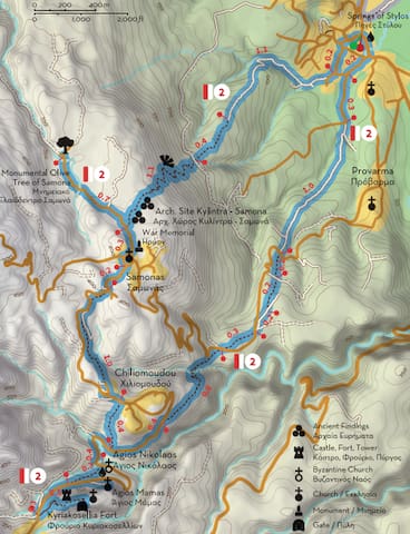
ROUTE 2 Part1 “Α journey through History”
PART A
Stylos - Kilindra - Monumental olive tree of Samonas - Chiliomoudou
Route 2 has been designed in order to promote the hinterland of Apokoronas, mainly the upper part of the Kiliaris valley, taking as reference points the monumental olive tree of Samonas, the fort of Kyriakosellia and the Byzantine church of Agios Nikolaos. From the springs of Stylos and the church of Agios Ioannis Theologos head west (uphill) and at the second crossroads after 150 meters turn left (south) and at the next junction right (southwest). Continue on this road for about 200 meters and turn right (west) at its end. About 270 meters further down this street, near the last houses of the village, turn right (northwest) follow a dirt road that narrows into a path some 800 meters above. After another 400 meters the path intersects a dirt road and continues even further uphill, to a location named Kylintra (1 km), at an altitude of 360 meters outside Samonas.
Archeological excavations have revealed traces of a settlement of the Late Minoan period (1560-1050 BC), tools and ceramics in this area. The strategic location of the hill shows there must have been a citadel here. According to Paul Faure, the name of the village Samonás has derived from the word “samos” or “sami”, which is often used to describe a steep place in high altitude. According to another theory, the village’s name is related to Samonas of mythology, son of Hermes and Rhene, while a third connects the village to Agios Samonas, to whom the locals have dedicated the right aisle of the church of Agios Efstathios, situated at the highest point of the village.
Before continuing to Samonas, it’s worth visiting the Monumental Olive Tree of Samonas, located at a site named Lakkos, about 700 meters from Kylintra. This olive belongs to a variety known as “tsounati” by locals and has been declared “monumental” by the Association of Olive-producing Municipalities of Crete, due to its age and size. At a height of one meter from the ground, the trunk of the tree has a maximum diameter of 5.25 meters and a perimeter of 12.90, while at its base it has a maximum diameter of 6.70 meters and a perimeter of 20 meters.
Continuing southwest from Samonas and at a distance of about 1.5 km you will find Chiliomoudou, a small village that holds tight on tradition, as here you can find the only olive mill in Greece that still operates in the traditional way (with mills and torvades), one of last workshops of Cretan musical instruments (which makes lutes, violins, mandolins and lyres) and one of the few workshops that still make sheep and goat bells, known as “léria” among Cretans.
From Chiliomoudou you can descend the slope south of the village and continue to the Byzantine church of Agios Nikolaos (800 meters away), one of the most beautiful and well-preserved in Crete, which we will describe extensively in our next post.
ATTENTION: Please note that the construction of the trails is in progress and the paths will not be accessible and completely safe until the delivery of the project in the summer of 2022.
Total length of Part A: 5.6 km, estimated time 2h 35΄
Total length of Route 2: 8.7 km, estimated time 4h 50΄
Map's Address:
https://scontent.fath7-1.fna.fbcdn.net/v/t39.30808-6/257625416_4452890141426062_9099983778982466636_n.png?stp=dst-png_s600x600&_nc_cat=110&ccb=1-6&_nc_sid=730e14&_nc_ohc=PArZPODKkXsAX_qdXxt&_nc_ht=scontent.fath7-1.fna&oh=00_AT_IkZjpeUUd8YxxgV95Y8Wp8OmEQ8OsuIN5YMk6Nzp3VA&oe=627E3D52
21 Einheimische empfehlen

Apokoronos
ROUTE 2 Part1 “Α journey through History”
PART A
Stylos - Kilindra - Monumental olive tree of Samonas - Chiliomoudou
Route 2 has been designed in order to promote the hinterland of Apokoronas, mainly the upper part of the Kiliaris valley, taking as reference points the monumental olive tree of Samonas, the fort of Kyriakosellia and the Byzantine church of Agios Nikolaos. From the springs of Stylos and the church of Agios Ioannis Theologos head west (uphill) and at the second crossroads after 150 meters turn left (south) and at the next junction right (southwest). Continue on this road for about 200 meters and turn right (west) at its end. About 270 meters further down this street, near the last houses of the village, turn right (northwest) follow a dirt road that narrows into a path some 800 meters above. After another 400 meters the path intersects a dirt road and continues even further uphill, to a location named Kylintra (1 km), at an altitude of 360 meters outside Samonas.
Archeological excavations have revealed traces of a settlement of the Late Minoan period (1560-1050 BC), tools and ceramics in this area. The strategic location of the hill shows there must have been a citadel here. According to Paul Faure, the name of the village Samonás has derived from the word “samos” or “sami”, which is often used to describe a steep place in high altitude. According to another theory, the village’s name is related to Samonas of mythology, son of Hermes and Rhene, while a third connects the village to Agios Samonas, to whom the locals have dedicated the right aisle of the church of Agios Efstathios, situated at the highest point of the village.
Before continuing to Samonas, it’s worth visiting the Monumental Olive Tree of Samonas, located at a site named Lakkos, about 700 meters from Kylintra. This olive belongs to a variety known as “tsounati” by locals and has been declared “monumental” by the Association of Olive-producing Municipalities of Crete, due to its age and size. At a height of one meter from the ground, the trunk of the tree has a maximum diameter of 5.25 meters and a perimeter of 12.90, while at its base it has a maximum diameter of 6.70 meters and a perimeter of 20 meters.
Continuing southwest from Samonas and at a distance of about 1.5 km you will find Chiliomoudou, a small village that holds tight on tradition, as here you can find the only olive mill in Greece that still operates in the traditional way (with mills and torvades), one of last workshops of Cretan musical instruments (which makes lutes, violins, mandolins and lyres) and one of the few workshops that still make sheep and goat bells, known as “léria” among Cretans.
From Chiliomoudou you can descend the slope south of the village and continue to the Byzantine church of Agios Nikolaos (800 meters away), one of the most beautiful and well-preserved in Crete, which we will describe extensively in our next post.
ATTENTION: Please note that the construction of the trails is in progress and the paths will not be accessible and completely safe until the delivery of the project in the summer of 2022.
Total length of Part A: 5.6 km, estimated time 2h 35΄
Total length of Route 2: 8.7 km, estimated time 4h 50΄
Map's Address:
https://scontent.fath7-1.fna.fbcdn.net/v/t39.30808-6/257625416_4452890141426062_9099983778982466636_n.png?stp=dst-png_s600x600&_nc_cat=110&ccb=1-6&_nc_sid=730e14&_nc_ohc=PArZPODKkXsAX_qdXxt&_nc_ht=scontent.fath7-1.fna&oh=00_AT_IkZjpeUUd8YxxgV95Y8Wp8OmEQ8OsuIN5YMk6Nzp3VA&oe=627E3D52
ROUTE 2 Part2 “Α journey through History”
PART B
Kyriakosellia (fort) - Agios Nikolaos church - Provarma - Stylos
If you walk this as a circular route (starting from and heading back to Stylos) and you have already walked Part A, you should have reached the Byzantine church of Agios Nikolaos descending from Chiliomoudou (800 meters away). If not, you could start your walk from Kyriakosellia, a small village that is said to have taken its name from the word for “saddle” (séla), or from the Cretan word “seli”, often used as a byword for mountain pass. When Enrico Pescatore occupied Crete in 1205 in the name of the Republic of Genoa, the fortress of Kyriakosellia (Rocca di San Nicoló) was one of the fifteen he chose to repair, but this did not prevent it from falling to the Skordili and Melissini families, who occupied it during the revolution of the two Sivriti in 1217 and kept it until 1236, when they handed it over to the Venetians by treaty (in exchange for some privileges). Inside the fort one can find the church of Agia Paraskevi, while at the western end of the castle there is a tower and a water tank.
Below the fortifications on the north side of the rock is the church of Agios Mámas, while lower in the valley (north of the castle or northeast of the village) is the church of Agios Nikolaos, one of the most beautiful and well-preserved Byzantine churches in Crete. The church was initially built in the 11th century as a single-aisled vaulted structure, but was later turned into a cruciform church with a dome in the 13th century. During the same period, its interior was decorated with excellent frescoes, many of which are still in good condition.
From here take the road to the north and then to the east for about 800 meters and turn right on a path below Chiliomoudou, walking as much until you cross the road that connects Samonas with Provarma. Cross the road and turn left (northwest), walking on a short path next to the street for about 300 meters. Then turn right on another dirt road that turns into a path for about 600 meters. Many places on this route have impressive views to the valley of Koiliaris. From here, you may follow the main road and visit Provarma, otherwise follow the signs and turn left (north) a bit before the village, walking for about 1 km on a dirt road that leads you to the outskirts of Stylos, about 500 meters from the springs.
ATTENTION: Please note that the construction of the trails is in progress and the paths will not be accessible and completely safe until the delivery of the project in the summer of 2022.
Total length of Part B: 5.1 km, estimated time 2h 15΄
Total length of Route 2: 8.7 km, estimated time 4h 50΄
Map's Address:
https://scontent.fath7-1.fna.fbcdn.net/v/t39.30808-6/259387983_4475449092503500_346253722123149589_n.png?stp=dst-png_s600x600&_nc_cat=103&ccb=1-6&_nc_sid=730e14&_nc_ohc=dQD7nHMritcAX-KCT-r&_nc_ht=scontent.fath7-1.fna&oh=00_AT96ERqhuGAlNM_WbC6UP4psevdEGjpVdHcjbGtLJSzlcQ&oe=627EC850
21 Einheimische empfehlen
Apokoronos
ROUTE 2 Part2 “Α journey through History”
PART B
Kyriakosellia (fort) - Agios Nikolaos church - Provarma - Stylos
If you walk this as a circular route (starting from and heading back to Stylos) and you have already walked Part A, you should have reached the Byzantine church of Agios Nikolaos descending from Chiliomoudou (800 meters away). If not, you could start your walk from Kyriakosellia, a small village that is said to have taken its name from the word for “saddle” (séla), or from the Cretan word “seli”, often used as a byword for mountain pass. When Enrico Pescatore occupied Crete in 1205 in the name of the Republic of Genoa, the fortress of Kyriakosellia (Rocca di San Nicoló) was one of the fifteen he chose to repair, but this did not prevent it from falling to the Skordili and Melissini families, who occupied it during the revolution of the two Sivriti in 1217 and kept it until 1236, when they handed it over to the Venetians by treaty (in exchange for some privileges). Inside the fort one can find the church of Agia Paraskevi, while at the western end of the castle there is a tower and a water tank.
Below the fortifications on the north side of the rock is the church of Agios Mámas, while lower in the valley (north of the castle or northeast of the village) is the church of Agios Nikolaos, one of the most beautiful and well-preserved Byzantine churches in Crete. The church was initially built in the 11th century as a single-aisled vaulted structure, but was later turned into a cruciform church with a dome in the 13th century. During the same period, its interior was decorated with excellent frescoes, many of which are still in good condition.
From here take the road to the north and then to the east for about 800 meters and turn right on a path below Chiliomoudou, walking as much until you cross the road that connects Samonas with Provarma. Cross the road and turn left (northwest), walking on a short path next to the street for about 300 meters. Then turn right on another dirt road that turns into a path for about 600 meters. Many places on this route have impressive views to the valley of Koiliaris. From here, you may follow the main road and visit Provarma, otherwise follow the signs and turn left (north) a bit before the village, walking for about 1 km on a dirt road that leads you to the outskirts of Stylos, about 500 meters from the springs.
ATTENTION: Please note that the construction of the trails is in progress and the paths will not be accessible and completely safe until the delivery of the project in the summer of 2022.
Total length of Part B: 5.1 km, estimated time 2h 15΄
Total length of Route 2: 8.7 km, estimated time 4h 50΄
Map's Address:
https://scontent.fath7-1.fna.fbcdn.net/v/t39.30808-6/259387983_4475449092503500_346253722123149589_n.png?stp=dst-png_s600x600&_nc_cat=103&ccb=1-6&_nc_sid=730e14&_nc_ohc=dQD7nHMritcAX-KCT-r&_nc_ht=scontent.fath7-1.fna&oh=00_AT96ERqhuGAlNM_WbC6UP4psevdEGjpVdHcjbGtLJSzlcQ&oe=627EC850
ROUTE 3
“Stone shepherd huts in the White Mountains” (29/11)
Frama - Profitis Ilias of Melidoni - Agio Pnevma (Holy Spirit) of Pemonia - Agio Pnevma Fre
This route is circular (it starts and ends at the same place) and does not pass through any village, as it was designed to connect some of the most impressive shepherds’ huts (mitata and koumi) of the White Mountains (Lefka Ori), using extensively old trails of light traffic, often known as “moularostrates” (mule paths). This route occupies the slopes between the hill Tria Korfalia and the peaks Agio Pneuma (2,262 meters) and Korda (1,611 meters) and has the advantage that the view changes constantly from slope to slope, allowing the hiker to become familiar with the natural and cultural landscape of the White Mountains without subjecting him or her to demanding altitude differences.
Route 3 starts from a location named Frama at an altitude of 660 meters. The only road that leads to Frama is from Melidoni (4 km away), although the route also crosses through areas that belong to the local communities of Pemonia and Fres. From Frama head southwest to Mitato Platsidaki, which you will meet at a distance of 1.5 km, at an altitude of 860 meters. From there the path continues northwest to Koumos Giorgioles (900 meters), from where you can enjoy excellent views of much of Apokoronas, from the Gulf of Souda to the Gulf of Almiros. Return through the same path for about 200 meters and turn right (southwest) at the next intersection, following another path that leads after 1.5 km to the church of Prophitis Ilias of Melidoni, at an altitude of 1,130 meters, where a festival is held every year on 19 or 20 July. At a short distance from the church it is worth visiting the two shepherd huts Apano Mitato and Memeti Kalyva, next to which you will find a source of fresh water.
From here the route follows another path that continues 1.7 km south to the church Agio Pnevma Pemonion (Holy Spirit of Pemonia), passing by the spring Platanaki (at about 2/3 of the route). At a short distance from Agio Pnevma you can visit Mitato Pyrgi (350 meters to the northeast), although the route continues south to the source Kato Nero (Hóses), crosses the stream and continues on the opposite slope of Mount Korda to Koumos Sartzetis and Mitato Ladogianni, where you arrive after 2.3 km. From here a path - branch of the main route leads after 600 meters to the church of Agio Pnevma Fre (Holy Spirit of Fres) and the homonymous spring, at an altitude of 1,140 meters. Alternatively, you can descend to Koumos Pappa (about 400 meters from Mitato Ladogianni) and from there to Frama (2.2 km), completing this beautiful circular route at the upper valleys of the Lefka Ori, also known as “Madára”.
ATTENTION: Please note that the construction of the trails is in progress and the paths will not be accessible and completely safe until the delivery of the project in the summer of 2022.
Total length of Route 3: 10.6 km (the main route, 12.2 km with branches), estimated time 4h 50΄
Map's Address:
https://scontent.fath7-1.fna.fbcdn.net/v/t39.30808-6/261052703_4498143573567385_5665008228710086308_n.png?stp=dst-png_p403x403&_nc_cat=107&ccb=1-6&_nc_sid=730e14&_nc_ohc=B1hy-55LZosAX9ujPry&_nc_ht=scontent.fath7-1.fna&oh=00_AT_2PhYbLnLP0QeRwYbrPF6G-T-OXKKTe6jPzcpjFzWoVg&oe=627D88B3
21 Einheimische empfehlen
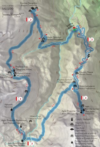
Apokoronos
ROUTE 3
“Stone shepherd huts in the White Mountains” (29/11)
Frama - Profitis Ilias of Melidoni - Agio Pnevma (Holy Spirit) of Pemonia - Agio Pnevma Fre
This route is circular (it starts and ends at the same place) and does not pass through any village, as it was designed to connect some of the most impressive shepherds’ huts (mitata and koumi) of the White Mountains (Lefka Ori), using extensively old trails of light traffic, often known as “moularostrates” (mule paths). This route occupies the slopes between the hill Tria Korfalia and the peaks Agio Pneuma (2,262 meters) and Korda (1,611 meters) and has the advantage that the view changes constantly from slope to slope, allowing the hiker to become familiar with the natural and cultural landscape of the White Mountains without subjecting him or her to demanding altitude differences.
Route 3 starts from a location named Frama at an altitude of 660 meters. The only road that leads to Frama is from Melidoni (4 km away), although the route also crosses through areas that belong to the local communities of Pemonia and Fres. From Frama head southwest to Mitato Platsidaki, which you will meet at a distance of 1.5 km, at an altitude of 860 meters. From there the path continues northwest to Koumos Giorgioles (900 meters), from where you can enjoy excellent views of much of Apokoronas, from the Gulf of Souda to the Gulf of Almiros. Return through the same path for about 200 meters and turn right (southwest) at the next intersection, following another path that leads after 1.5 km to the church of Prophitis Ilias of Melidoni, at an altitude of 1,130 meters, where a festival is held every year on 19 or 20 July. At a short distance from the church it is worth visiting the two shepherd huts Apano Mitato and Memeti Kalyva, next to which you will find a source of fresh water.
From here the route follows another path that continues 1.7 km south to the church Agio Pnevma Pemonion (Holy Spirit of Pemonia), passing by the spring Platanaki (at about 2/3 of the route). At a short distance from Agio Pnevma you can visit Mitato Pyrgi (350 meters to the northeast), although the route continues south to the source Kato Nero (Hóses), crosses the stream and continues on the opposite slope of Mount Korda to Koumos Sartzetis and Mitato Ladogianni, where you arrive after 2.3 km. From here a path - branch of the main route leads after 600 meters to the church of Agio Pnevma Fre (Holy Spirit of Fres) and the homonymous spring, at an altitude of 1,140 meters. Alternatively, you can descend to Koumos Pappa (about 400 meters from Mitato Ladogianni) and from there to Frama (2.2 km), completing this beautiful circular route at the upper valleys of the Lefka Ori, also known as “Madára”.
ATTENTION: Please note that the construction of the trails is in progress and the paths will not be accessible and completely safe until the delivery of the project in the summer of 2022.
Total length of Route 3: 10.6 km (the main route, 12.2 km with branches), estimated time 4h 50΄
Map's Address:
https://scontent.fath7-1.fna.fbcdn.net/v/t39.30808-6/261052703_4498143573567385_5665008228710086308_n.png?stp=dst-png_p403x403&_nc_cat=107&ccb=1-6&_nc_sid=730e14&_nc_ohc=B1hy-55LZosAX9ujPry&_nc_ht=scontent.fath7-1.fna&oh=00_AT_2PhYbLnLP0QeRwYbrPF6G-T-OXKKTe6jPzcpjFzWoVg&oe=627D88B3
ROUTE 4Part1
“The cypress villages”
PART A (6/12)
Vafes - Tzitzifes - Fres
Route 4 connects some of the most picturesque villages of the Riza region (the foothills of the White Mountains), which could not be left out of the network of paths of Apokoronas. Although this route is circular, Vafes has been designated as its a starting point, due to the fact that Route 5 also passes through the village. It should be noted however that all four villages (Vafes, Tzitzifes, Fres, Nipos) of the route have cafes and shops that operate all year round, which makes them ideal for stopping or refueling during the hike.
Vafes is estimated to have been founded in the mid-8th century, when neighboring Kourtsa was destroyed by the Arabs and many fled to this location. During the 12th century, the Skordilis family settled in Vafe, which was recognized as noble during the Venetian period. After the conquest of Apokoronas by the Ottomans in 1646, Vafes became property of a Muslim public benefit institution (vakıf) connected to the mosque of Fındık Haji Mehmet Pasha in Heraklion (Kandiye). Several noteworthy buildings were built this period, such as the two-aisled church of Christ, the residence of the priest Emmanuel Skordylis of 1745 and a series of vaulted structures attributed to the janissary Ibrahim Alidakis. About 400 meters away, visitors can find the cave of Kryonerida, which served several times as a refuge for Christians, but was discovered in August 1821 by the Ottomans, who lit a fire at its entrance, causing death by suffocation to about 130 women and children that had hidden inside it.
From Vafes the route continues west following the foothills of the mountain to Tzitzifes, which you should find after 2.5 km. The first building you will encounter is the church Gennesio tis Theotokou (Birth of Virgin Many), shortly after which you will turn right at the cemetery and descend to Agios Ioannis Prodromos, near the center of the village. Following the signs from here you will descend to the lower side of the ravine that separates the two neighborhoods of the village and is known as Faragouli, reaching the fountain of Vrisi (200 meters below), where many important meetings of Cretan rebels took place in the 19th century. It should be noted that Tzitzifes is the only village in Crete where karabassi is still produced, an essential oil produced from laurel which has healing as well as ornamental properties.
Leaving Tzitzifes behind, head north northwest following a dirt road on a lower level than the paved road to Fres, reaching its main square after 1.6 km. A small road that starts from “Kamaraki” leads to the church Panagia ton dyo Vrachon (Madonna of the two Rocks), a picturesque church of the 13th century, while the school of the village hosted the Pancretan Revolutionary Assembly from November 1877 to late January 1878. Two other points of interest in the village are the Giannoulakis Municipal Gallery and the impressive church of Panagia Evangelistria, which was built during the period 1856-1938 and is a typical example of modern ecclesiastical architecture with remarkable wall paintings. At Fres you can also find several options for food or coffee, or alternatively “refuel” and continue on to Part B of Route 4, returning to Vafes via Nipos.
ATTENTION: Please note that the construction of the trails is in progress and the paths will not be accessible and completely safe until the delivery of the project in the summer of 2022.
Total length of Part A: 5 km, estimated time 2h 10΄
Total length of Route 4: 11 km (the main route), estimated time 4h 45΄
Map's Address:
https://scontent.fath7-1.fna.fbcdn.net/v/t39.30808-6/264517482_4519665848081824_241635178155247786_n.jpg?stp=dst-jpg_s600x600&_nc_cat=102&ccb=1-6&_nc_sid=730e14&_nc_ohc=J84GRGItOGYAX-NyX01&_nc_ht=scontent.fath7-1.fna&oh=00_AT_ULwjWniMTBFzLWBcvZB_KqaM96WfX0B-C4S9zVNKaYQ&oe=627E6D86
21 Einheimische empfehlen
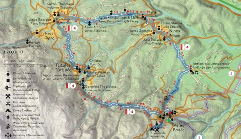
Apokoronos
ROUTE 4Part1
“The cypress villages”
PART A (6/12)
Vafes - Tzitzifes - Fres
Route 4 connects some of the most picturesque villages of the Riza region (the foothills of the White Mountains), which could not be left out of the network of paths of Apokoronas. Although this route is circular, Vafes has been designated as its a starting point, due to the fact that Route 5 also passes through the village. It should be noted however that all four villages (Vafes, Tzitzifes, Fres, Nipos) of the route have cafes and shops that operate all year round, which makes them ideal for stopping or refueling during the hike.
Vafes is estimated to have been founded in the mid-8th century, when neighboring Kourtsa was destroyed by the Arabs and many fled to this location. During the 12th century, the Skordilis family settled in Vafe, which was recognized as noble during the Venetian period. After the conquest of Apokoronas by the Ottomans in 1646, Vafes became property of a Muslim public benefit institution (vakıf) connected to the mosque of Fındık Haji Mehmet Pasha in Heraklion (Kandiye). Several noteworthy buildings were built this period, such as the two-aisled church of Christ, the residence of the priest Emmanuel Skordylis of 1745 and a series of vaulted structures attributed to the janissary Ibrahim Alidakis. About 400 meters away, visitors can find the cave of Kryonerida, which served several times as a refuge for Christians, but was discovered in August 1821 by the Ottomans, who lit a fire at its entrance, causing death by suffocation to about 130 women and children that had hidden inside it.
From Vafes the route continues west following the foothills of the mountain to Tzitzifes, which you should find after 2.5 km. The first building you will encounter is the church Gennesio tis Theotokou (Birth of Virgin Many), shortly after which you will turn right at the cemetery and descend to Agios Ioannis Prodromos, near the center of the village. Following the signs from here you will descend to the lower side of the ravine that separates the two neighborhoods of the village and is known as Faragouli, reaching the fountain of Vrisi (200 meters below), where many important meetings of Cretan rebels took place in the 19th century. It should be noted that Tzitzifes is the only village in Crete where karabassi is still produced, an essential oil produced from laurel which has healing as well as ornamental properties.
Leaving Tzitzifes behind, head north northwest following a dirt road on a lower level than the paved road to Fres, reaching its main square after 1.6 km. A small road that starts from “Kamaraki” leads to the church Panagia ton dyo Vrachon (Madonna of the two Rocks), a picturesque church of the 13th century, while the school of the village hosted the Pancretan Revolutionary Assembly from November 1877 to late January 1878. Two other points of interest in the village are the Giannoulakis Municipal Gallery and the impressive church of Panagia Evangelistria, which was built during the period 1856-1938 and is a typical example of modern ecclesiastical architecture with remarkable wall paintings. At Fres you can also find several options for food or coffee, or alternatively “refuel” and continue on to Part B of Route 4, returning to Vafes via Nipos.
ATTENTION: Please note that the construction of the trails is in progress and the paths will not be accessible and completely safe until the delivery of the project in the summer of 2022.
Total length of Part A: 5 km, estimated time 2h 10΄
Total length of Route 4: 11 km (the main route), estimated time 4h 45΄
Map's Address:
https://scontent.fath7-1.fna.fbcdn.net/v/t39.30808-6/264517482_4519665848081824_241635178155247786_n.jpg?stp=dst-jpg_s600x600&_nc_cat=102&ccb=1-6&_nc_sid=730e14&_nc_ohc=J84GRGItOGYAX-NyX01&_nc_ht=scontent.fath7-1.fna&oh=00_AT_ULwjWniMTBFzLWBcvZB_KqaM96WfX0B-C4S9zVNKaYQ&oe=627E6D86
Path4 PART B
Fres - Nipos - Limnopigado - Fres
Part B of Route 4 runs at a lower altitude than Part A, but includes several points with excellent views of the villages of Riza and the White Mountains (Lefka Ori). Starting from Fres, you will look for the crossroads near the northern entrance of the village to the churches of Michael the Archangel and St. Anthony. Continuing on the same dirt road, a few kilometers east you will find the church of Saints Constantine and Helen and half a kilometer below the Rafioli spring, which has always been a meeting point for the Nipians, both for its gurgling waters and the landscape of special of natural beauty around it.
From here you will ascend to Nipos, which is less than 700 meters away. According to Xanthoudidis, this area used to be a grazing site for horses (ippos in ancient Greek), where a sanctuary was later built. Its name was Ippokorónion, which later evolved to Apokoronas, the current name of the province. According to another theory, the village’s name is related to the word napos, which means “plain” and was corrupted over time to Nipos. According to a third version, the village was originally named Rahi and was renamed Nippos after a Venetian official in 1550. In the center of the village you will find the churches of Timios Stavros and Agios Georgios, beautifully preserved old houses and a monument to the prominent and non-fallen of the village, such as Theoklis N. Kakatsis (Kakatsakis), Emmanuel Katsigaris-Karamanolis and the lieutenant Ioannis Kouromichelakis, who was killed in Kale Grotto of Asia Minor in 1921.
From the center of Nipos head east along the main road to Vrisses for about 300 meters and turn right (south) towards Limnopigado, a plateau 1km away where locals from the surrounding villages (mainly from Nipos and Vafes) used to come for water and socializing. At this location you can now find a small spring, a chapel dedicated to the Ascension (Analipsi) and some benches where you can rest. From here a dirt road leads east to the main road to Vafes (1 km) and Vrisses (3 km), but the route continues southwest (uphill) to Vafes, which you will reach after a 1.6 km, passing through a vineyard and entering the village from the north.
ATTENTION: Please note that the construction of the trails is in progress and the paths will not be accessible and completely safe until the delivery of the project in the summer of 2022.
Total length of Part A: 6 km, estimated time 2h 35΄
Total length of Route 4: 11 km (the main route), estimated time 4h 45΄
Map's Address:
https://scontent.fath7-1.fna.fbcdn.net/v/t39.30808-6/267174449_4547804985267910_5450442682024719045_n.jpg?stp=dst-jpg_p370x247&_nc_cat=111&ccb=1-5&_nc_sid=730e14&_nc_ohc=TTaYox0_1bkAX_n3rW3&_nc_ht=scontent.fath7-1.fna&oh=00_AT8uEX0WxuT-8ILsNnKu2YDo5Rp_0_aSwu5VQAmpEaTzFg&oe=627842F2
Map's Address:
https://scontent.fath7-1.fna.fbcdn.net/v/t39.30808-6/266166554_4544268372288238_6566288814471495922_n.jpg?stp=dst-jpg_s600x600&_nc_cat=110&ccb=1-6&_nc_sid=730e14&_nc_ohc=l12a03i4B-QAX9MHdnr&_nc_ht=scontent.fath7-1.fna&oh=00_AT8pxidU3RU5zQxeJA-m2ayugEB-D4qORG3nb0gN58-BGg&oe=627D3821
21 Einheimische empfehlen

Apokoronos
Path4 PART B
Fres - Nipos - Limnopigado - Fres
Part B of Route 4 runs at a lower altitude than Part A, but includes several points with excellent views of the villages of Riza and the White Mountains (Lefka Ori). Starting from Fres, you will look for the crossroads near the northern entrance of the village to the churches of Michael the Archangel and St. Anthony. Continuing on the same dirt road, a few kilometers east you will find the church of Saints Constantine and Helen and half a kilometer below the Rafioli spring, which has always been a meeting point for the Nipians, both for its gurgling waters and the landscape of special of natural beauty around it.
From here you will ascend to Nipos, which is less than 700 meters away. According to Xanthoudidis, this area used to be a grazing site for horses (ippos in ancient Greek), where a sanctuary was later built. Its name was Ippokorónion, which later evolved to Apokoronas, the current name of the province. According to another theory, the village’s name is related to the word napos, which means “plain” and was corrupted over time to Nipos. According to a third version, the village was originally named Rahi and was renamed Nippos after a Venetian official in 1550. In the center of the village you will find the churches of Timios Stavros and Agios Georgios, beautifully preserved old houses and a monument to the prominent and non-fallen of the village, such as Theoklis N. Kakatsis (Kakatsakis), Emmanuel Katsigaris-Karamanolis and the lieutenant Ioannis Kouromichelakis, who was killed in Kale Grotto of Asia Minor in 1921.
From the center of Nipos head east along the main road to Vrisses for about 300 meters and turn right (south) towards Limnopigado, a plateau 1km away where locals from the surrounding villages (mainly from Nipos and Vafes) used to come for water and socializing. At this location you can now find a small spring, a chapel dedicated to the Ascension (Analipsi) and some benches where you can rest. From here a dirt road leads east to the main road to Vafes (1 km) and Vrisses (3 km), but the route continues southwest (uphill) to Vafes, which you will reach after a 1.6 km, passing through a vineyard and entering the village from the north.
ATTENTION: Please note that the construction of the trails is in progress and the paths will not be accessible and completely safe until the delivery of the project in the summer of 2022.
Total length of Part A: 6 km, estimated time 2h 35΄
Total length of Route 4: 11 km (the main route), estimated time 4h 45΄
Map's Address:
https://scontent.fath7-1.fna.fbcdn.net/v/t39.30808-6/267174449_4547804985267910_5450442682024719045_n.jpg?stp=dst-jpg_p370x247&_nc_cat=111&ccb=1-5&_nc_sid=730e14&_nc_ohc=TTaYox0_1bkAX_n3rW3&_nc_ht=scontent.fath7-1.fna&oh=00_AT8uEX0WxuT-8ILsNnKu2YDo5Rp_0_aSwu5VQAmpEaTzFg&oe=627842F2
Map's Address:
https://scontent.fath7-1.fna.fbcdn.net/v/t39.30808-6/266166554_4544268372288238_6566288814471495922_n.jpg?stp=dst-jpg_s600x600&_nc_cat=110&ccb=1-6&_nc_sid=730e14&_nc_ohc=l12a03i4B-QAX9MHdnr&_nc_ht=scontent.fath7-1.fna&oh=00_AT8pxidU3RU5zQxeJA-m2ayugEB-D4qORG3nb0gN58-BGg&oe=627D3821
ROUTE 5PartA
“All of Apokoronas in one journey”
PART A
Vrisses - Elliniki Kamara - Maza
Route 5 is the longest route of the network of paths of Apokoronas, with a total length of 17.4 km. Through it the hiker will be able to get acquainted with many of the cultural monuments of the area, as well as amazing trails that had fallen into disuse for several years. This route starts from the village of Vrisses, seat of the Municipality of Apokoronas, which was founded at the beginning of the 20th century near the confluence of the rivers Boutakas and Farmakera, from which emerges the river Vrissianos. The bridge in the center of the village became a target of the Luftwaffe during the last phase of the Battle of Crete (end of May 1941), as thousands of Allied troops passed over it on their way to Sfakia, in order to be evacuated to Egypt.
The path starts from this bridge and follows Vrissianos river to the southeast, through a landscape of rare natural beauty. The landscape changes depending on the time of the year, but in any case, it leads you after 2 km to Elliniki Kamara (Greek / Hellenistic Arch), one of the oldest arched bridges surviving in Crete. It was built during the Hellenistic period (323-30 BC) but has several later additions. It was part of the main road that connected Chania with Rethimno, known during the Venetian occupation as “Strada Reale” (Royal Road). From Elliniki Kamara continue uphill (south) for about 0.5 km along a small asphalt road, which narrows into a path in a small gorge between the settlements of Filippou and Maza. As you walk, you’ll find yourself in a lush landscape with few traces of human presence.
This gorge is about 1.5 km long and leads to Filippou, a small settlement that belongs administratively to Vrisses. From here you can move west along the asphalt road and return to Vrisses, or follow the path signs (east) to Maza, where you can visit the one-room church of Agios Nikolaos in the center of the village. The church is decorated with impressive frescoes made by the hagiographer Ioannis Pagomenos in 1325. The inscription above the entrance reads “church of Agios Nikolaos Mazianos”, which implies the village pre-existed the church. Tombs of unknown date were discovered in and around the church, while visitors can also find the church of the Savior (Sotiras) of the 16th century a bit further away. The village is mentioned as Masa by Barozzi in 1577, as Maxa Filippu Ganbassa (Massa, Filippou and Habatha) by Castrofilaca in 1583 and as Masa Alicambo by Basilicata in 1630. An asphalt road connects Maza to the new national road, but we suggest you continue south to Alikambos and the other mountain villages of Kryonerida. The route will definitely compensate you.
ATTENTION: Please note that the construction of the trails is in progress and the paths will not be accessible and completely safe until the delivery of the project in the summer of 2022.
Total length of Part A: 5.7, estimated time 2h 30'
Total length of Route 5: 17.4 km, estimated time 7h 30'
Map's Address:
https://scontent.fath7-1.fna.fbcdn.net/v/t39.30808-6/269601771_4573922075989534_3448140352638109658_n.jpg?stp=dst-jpg_p370x247&_nc_cat=108&ccb=1-6&_nc_sid=730e14&_nc_ohc=ngn4FM5Ul90AX9tajGS&_nc_ht=scontent.fath7-1.fna&oh=00_AT-v2dbtLyPchXIduyUaJ0UAlwCGyI5-1VKiZ0c4s6ARJA&oe=627CE6E8
21 Einheimische empfehlen

Apokoronos
ROUTE 5PartA
“All of Apokoronas in one journey”
PART A
Vrisses - Elliniki Kamara - Maza
Route 5 is the longest route of the network of paths of Apokoronas, with a total length of 17.4 km. Through it the hiker will be able to get acquainted with many of the cultural monuments of the area, as well as amazing trails that had fallen into disuse for several years. This route starts from the village of Vrisses, seat of the Municipality of Apokoronas, which was founded at the beginning of the 20th century near the confluence of the rivers Boutakas and Farmakera, from which emerges the river Vrissianos. The bridge in the center of the village became a target of the Luftwaffe during the last phase of the Battle of Crete (end of May 1941), as thousands of Allied troops passed over it on their way to Sfakia, in order to be evacuated to Egypt.
The path starts from this bridge and follows Vrissianos river to the southeast, through a landscape of rare natural beauty. The landscape changes depending on the time of the year, but in any case, it leads you after 2 km to Elliniki Kamara (Greek / Hellenistic Arch), one of the oldest arched bridges surviving in Crete. It was built during the Hellenistic period (323-30 BC) but has several later additions. It was part of the main road that connected Chania with Rethimno, known during the Venetian occupation as “Strada Reale” (Royal Road). From Elliniki Kamara continue uphill (south) for about 0.5 km along a small asphalt road, which narrows into a path in a small gorge between the settlements of Filippou and Maza. As you walk, you’ll find yourself in a lush landscape with few traces of human presence.
This gorge is about 1.5 km long and leads to Filippou, a small settlement that belongs administratively to Vrisses. From here you can move west along the asphalt road and return to Vrisses, or follow the path signs (east) to Maza, where you can visit the one-room church of Agios Nikolaos in the center of the village. The church is decorated with impressive frescoes made by the hagiographer Ioannis Pagomenos in 1325. The inscription above the entrance reads “church of Agios Nikolaos Mazianos”, which implies the village pre-existed the church. Tombs of unknown date were discovered in and around the church, while visitors can also find the church of the Savior (Sotiras) of the 16th century a bit further away. The village is mentioned as Masa by Barozzi in 1577, as Maxa Filippu Ganbassa (Massa, Filippou and Habatha) by Castrofilaca in 1583 and as Masa Alicambo by Basilicata in 1630. An asphalt road connects Maza to the new national road, but we suggest you continue south to Alikambos and the other mountain villages of Kryonerida. The route will definitely compensate you.
ATTENTION: Please note that the construction of the trails is in progress and the paths will not be accessible and completely safe until the delivery of the project in the summer of 2022.
Total length of Part A: 5.7, estimated time 2h 30'
Total length of Route 5: 17.4 km, estimated time 7h 30'
Map's Address:
https://scontent.fath7-1.fna.fbcdn.net/v/t39.30808-6/269601771_4573922075989534_3448140352638109658_n.jpg?stp=dst-jpg_p370x247&_nc_cat=108&ccb=1-6&_nc_sid=730e14&_nc_ohc=ngn4FM5Ul90AX9tajGS&_nc_ht=scontent.fath7-1.fna&oh=00_AT-v2dbtLyPchXIduyUaJ0UAlwCGyI5-1VKiZ0c4s6ARJA&oe=627CE6E8
ROUTE 5Part2
“All of Apokoronas in one journey”
PART B
Maza - Alikambos - Embrosneros
Part B of Route 5 moves at a higher altitude than Parts A and C, but any difficulty that may arise is “compensated” by the views you will enjoy at several points along the way and by the beauty of the villages and nature you will encounter. The first part of the route from Maza to Alikambos (1.3 km) is the steepest, but it follows an old path, a small part of which was paved a few years ago to connect the two villages by road.
Alikambos is the easternmost village of the area called “Riza” (foothills) of the White Mountains (Lefka Ori), located at an altitude of 300 meters. We do not know when the village was founded, but archeologists estimate there must have been a Minoan peak sanctuary in this area, called “Archavli”, a name that today survives in the name of the cultural association of the village. In the 12th century the village and its broader area became a fief of the Skordili family, a branch of which acquired the nickname Malafarás after the 13th century. During the following two centuries the village prospered, leading to the construction and decoration of notable churches, such as that of the Assumption of the Virgin (Kimisi tis Theotókou), decorated by Ioannis Pagomenos around 1315. Alikambos is also known as the birthplace of Iosif Lekanidis, a lawyer that became secretary general of the Metapoliteftiki Committee and played a major role during the events of 1895-1898 in Crete. Once you reach the War Memorial at the main square of the village, turn right (west) to Emprosneros, descending towards Douraki Winery (1.1 km), where it’s worth catching or organizing a tour and tasting the local wines.
From the winery, continue south along the road to Sfakia, turning right (west) at the sign 700 meters below. Follow a small path that gradually becomes a dirt road and later a road that leads to Embrosneros, some 2.3 km away. Embrósneros (or Brónieros) is also one of the villages of “Riza”, located at an altitude of 241 meters. The village’s name is most probably connected to a small stone fountain at the springs of river Boutakas. Entering the village from the north, the fountain is one of the first things you see, hence embros-nero (translated as “water first”). Once you reach the Mesochori district of the village, look for Alidakis Tower, home and base of the mighty janissary Ibrahim Alidakis, who controlled a big part of Apokoronas at the end of the 18th century, from the river Mousselas to the east to the hills of Vamos and Stylos. After the end of Daskalogiannis’ revolt in 1770, Alidakis planned to campaign against the Sfakians and impose his rule, but the latter learnt about his plans and attacked his tower first (probably in 1773), killing Alidakis and most of those who defended him. In the village one can find many old and newer churches, the most notable being those of Agios Antonios, Profitis Ilias, Agia Anna, Agios Titos and Panagia, while another point of interest is the Municipal Theater “Mikis Theodorakis”, where many artistic and music events are hosted every year.
From Embrosneros you can return to Vrisses following a path along the river Boutakas (3.8 km), or continue west to Vafes (2.8 km), from where you can get back to Vrisses or follow Route 4 to the “Villages of the cypress trees” described in a previous notification.
ATTENTION: Please note that the construction of the trails is in progress and the paths will not be accessible and completely safe until the delivery of the project in the summer of 2022.
Total length of Part B: 5.5 km, estimated time 2h 20΄
Total length of Route 5: 17.4 km, estimated time 7h 30΄
Map's Address:
https://scontent.fath7-1.fna.fbcdn.net/v/t39.30808-6/267174449_4547804985267910_5450442682024719045_n.jpg?stp=dst-jpg_p370x247&_nc_cat=111&ccb=1-6&_nc_sid=730e14&_nc_ohc=JdiAY1Uvi7IAX9r_r43&_nc_ht=scontent.fath7-1.fna&oh=00_AT92VgLlS5H-6HqtyJPZWr8LzuvFVtukb3LWECytSrGAxA&oe=627E31B2
21 Einheimische empfehlen
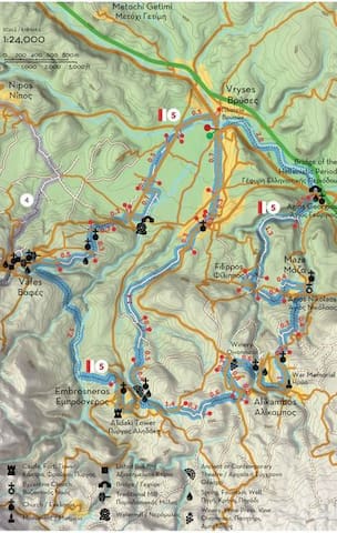
Apokoronos
ROUTE 5Part2
“All of Apokoronas in one journey”
PART B
Maza - Alikambos - Embrosneros
Part B of Route 5 moves at a higher altitude than Parts A and C, but any difficulty that may arise is “compensated” by the views you will enjoy at several points along the way and by the beauty of the villages and nature you will encounter. The first part of the route from Maza to Alikambos (1.3 km) is the steepest, but it follows an old path, a small part of which was paved a few years ago to connect the two villages by road.
Alikambos is the easternmost village of the area called “Riza” (foothills) of the White Mountains (Lefka Ori), located at an altitude of 300 meters. We do not know when the village was founded, but archeologists estimate there must have been a Minoan peak sanctuary in this area, called “Archavli”, a name that today survives in the name of the cultural association of the village. In the 12th century the village and its broader area became a fief of the Skordili family, a branch of which acquired the nickname Malafarás after the 13th century. During the following two centuries the village prospered, leading to the construction and decoration of notable churches, such as that of the Assumption of the Virgin (Kimisi tis Theotókou), decorated by Ioannis Pagomenos around 1315. Alikambos is also known as the birthplace of Iosif Lekanidis, a lawyer that became secretary general of the Metapoliteftiki Committee and played a major role during the events of 1895-1898 in Crete. Once you reach the War Memorial at the main square of the village, turn right (west) to Emprosneros, descending towards Douraki Winery (1.1 km), where it’s worth catching or organizing a tour and tasting the local wines.
From the winery, continue south along the road to Sfakia, turning right (west) at the sign 700 meters below. Follow a small path that gradually becomes a dirt road and later a road that leads to Embrosneros, some 2.3 km away. Embrósneros (or Brónieros) is also one of the villages of “Riza”, located at an altitude of 241 meters. The village’s name is most probably connected to a small stone fountain at the springs of river Boutakas. Entering the village from the north, the fountain is one of the first things you see, hence embros-nero (translated as “water first”). Once you reach the Mesochori district of the village, look for Alidakis Tower, home and base of the mighty janissary Ibrahim Alidakis, who controlled a big part of Apokoronas at the end of the 18th century, from the river Mousselas to the east to the hills of Vamos and Stylos. After the end of Daskalogiannis’ revolt in 1770, Alidakis planned to campaign against the Sfakians and impose his rule, but the latter learnt about his plans and attacked his tower first (probably in 1773), killing Alidakis and most of those who defended him. In the village one can find many old and newer churches, the most notable being those of Agios Antonios, Profitis Ilias, Agia Anna, Agios Titos and Panagia, while another point of interest is the Municipal Theater “Mikis Theodorakis”, where many artistic and music events are hosted every year.
From Embrosneros you can return to Vrisses following a path along the river Boutakas (3.8 km), or continue west to Vafes (2.8 km), from where you can get back to Vrisses or follow Route 4 to the “Villages of the cypress trees” described in a previous notification.
ATTENTION: Please note that the construction of the trails is in progress and the paths will not be accessible and completely safe until the delivery of the project in the summer of 2022.
Total length of Part B: 5.5 km, estimated time 2h 20΄
Total length of Route 5: 17.4 km, estimated time 7h 30΄
Map's Address:
https://scontent.fath7-1.fna.fbcdn.net/v/t39.30808-6/267174449_4547804985267910_5450442682024719045_n.jpg?stp=dst-jpg_p370x247&_nc_cat=111&ccb=1-6&_nc_sid=730e14&_nc_ohc=JdiAY1Uvi7IAX9r_r43&_nc_ht=scontent.fath7-1.fna&oh=00_AT92VgLlS5H-6HqtyJPZWr8LzuvFVtukb3LWECytSrGAxA&oe=627E31B2
ROUTE 5Part3
“All of Apokoronas in one journey”
PART C
Embrosneros - Vafes - Vrisses
Part C of Route 5 is generally downhill, but passes through some beautiful landscapes, such as those of Kryonerida Gorge and the river Boutakas valley. From Alidakis Tower or “Mikis Theodorakis” Theater in Embrosneros, head to the church of Agios Titos and Kimisi (St Titus and the Assumption of the Virgin), located at the northwestern end of the village, near the road to Vrisses. Continue on this road (northwards) for about 150 meters and just before the junction to the temple of Michael the Archangel, turn left (northwest) on a dirt road (to the left of two other roads that continue north) and follow an old path that leads to Vafes.
About 600 meters away, having left the village behind, you will descend to the Gorge of Kryonerida, following the stream (northwards) for about 700 meters. Then turn left (west) once you see the signs and red-white marks and walk slightly uphill on the west side of the gorge, finding an old path (some 680 meters away) that leads to Vafes (450 meters).
You can find more information about Vafes in the description of Route 4, as the village is also the beginning and end of that route, which connects it to Tzitzifes, Fres and Nipos. Alternatively, continue on the last part of Route 5, heading east from the main square and turning right at the first road after the Voloudaki Olive Mill (230 meters from the monument). Continue right (straight as you walk) at the next junction (270 meters below) and then right once more at the next one (after 250 meters). Some 290 meters further away you will arrive at a cemetery, continue north and you will meet the road (300 meters away).
The path bisects the road and continues north (for 180 meters) to the 15th century church of Agii Asomati. From here, continue east along the road to Vrisses and 700 meters away turn right (east) in order to admire an old stone bridge called Kamara tou Koutsou (220 meters away), next to which you can find the homonymous watermill. Walk next to the river for about 500 meters and then turn left (west), in order to return to the “straight road of Vafes” which leads to Vrisses after 1.8 km.
ATTENTION: Please note that the construction of the trails is in progress and the paths will not be accessible and completely safe until the delivery of the project in the summer of 2022.
Total length of Part C: 6.2 km, estimated time 2h 40΄
Total length of Route 5: 17.4 km, estimated time 7h 30΄
Map's Address:
https://scontent.fath7-1.fna.fbcdn.net/v/t39.30808-6/266369103_4548694315178977_7568000440327698568_n.jpg?stp=dst-jpg_p370x247&_nc_cat=102&ccb=1-6&_nc_sid=730e14&_nc_ohc=P2ju5p9H3SgAX-Bz--c&_nc_ht=scontent.fath7-1.fna&oh=00_AT_j976nzvebbHS-FiKkXXB7NI7nX07IEzbPzqHetcJqMw&oe=627DC14E
21 Einheimische empfehlen

Apokoronos
ROUTE 5Part3
“All of Apokoronas in one journey”
PART C
Embrosneros - Vafes - Vrisses
Part C of Route 5 is generally downhill, but passes through some beautiful landscapes, such as those of Kryonerida Gorge and the river Boutakas valley. From Alidakis Tower or “Mikis Theodorakis” Theater in Embrosneros, head to the church of Agios Titos and Kimisi (St Titus and the Assumption of the Virgin), located at the northwestern end of the village, near the road to Vrisses. Continue on this road (northwards) for about 150 meters and just before the junction to the temple of Michael the Archangel, turn left (northwest) on a dirt road (to the left of two other roads that continue north) and follow an old path that leads to Vafes.
About 600 meters away, having left the village behind, you will descend to the Gorge of Kryonerida, following the stream (northwards) for about 700 meters. Then turn left (west) once you see the signs and red-white marks and walk slightly uphill on the west side of the gorge, finding an old path (some 680 meters away) that leads to Vafes (450 meters).
You can find more information about Vafes in the description of Route 4, as the village is also the beginning and end of that route, which connects it to Tzitzifes, Fres and Nipos. Alternatively, continue on the last part of Route 5, heading east from the main square and turning right at the first road after the Voloudaki Olive Mill (230 meters from the monument). Continue right (straight as you walk) at the next junction (270 meters below) and then right once more at the next one (after 250 meters). Some 290 meters further away you will arrive at a cemetery, continue north and you will meet the road (300 meters away).
The path bisects the road and continues north (for 180 meters) to the 15th century church of Agii Asomati. From here, continue east along the road to Vrisses and 700 meters away turn right (east) in order to admire an old stone bridge called Kamara tou Koutsou (220 meters away), next to which you can find the homonymous watermill. Walk next to the river for about 500 meters and then turn left (west), in order to return to the “straight road of Vafes” which leads to Vrisses after 1.8 km.
ATTENTION: Please note that the construction of the trails is in progress and the paths will not be accessible and completely safe until the delivery of the project in the summer of 2022.
Total length of Part C: 6.2 km, estimated time 2h 40΄
Total length of Route 5: 17.4 km, estimated time 7h 30΄
Map's Address:
https://scontent.fath7-1.fna.fbcdn.net/v/t39.30808-6/266369103_4548694315178977_7568000440327698568_n.jpg?stp=dst-jpg_p370x247&_nc_cat=102&ccb=1-6&_nc_sid=730e14&_nc_ohc=P2ju5p9H3SgAX-Bz--c&_nc_ht=scontent.fath7-1.fna&oh=00_AT_j976nzvebbHS-FiKkXXB7NI7nX07IEzbPzqHetcJqMw&oe=627DC14E
ROUTE 6
“At the outskirts of the historic capital of Apokoronas”
PART A
Vamos - Douliana - Gavalochori
The area of central Apokoronas is known for its emphasis on alternative forms of tourism, such as agrotourism. It attracts a large number of visitors every year, while many foreign nationals have chosen to settle here temporarily or permanently. Many locals and visitors alike have a preference for hiking, usually on rural roads between villages or on their outskirts. Route 6 is actually an attempt to connect most of these villages, in a circular route that will start and end at Vamos, the historic seat of the Municipality of Apokoronas.
According to oral tradition, Vamos was founded in the 8th century, shortly after a group of Arabs exiled from Andalucia occupied Crete. The village remained in obscurity during the Venetian occupation, but due to its strategic location it became the seat of the Prefecture of Sfakia in 1867 and the site where many public buildings were built, such as the Administration building (Serayo), the Ottoman barracks (koumesionas or kışla), warehouses, tanks and schools. Route 6 starts from the central (upper) square of Vamos and leads you to its old neighborhood, passing by Kalderimi, an old cobbled street, the Maidens’ School (Parthenagogio) and many old houses and churches.
After walking through the old neighborhood of Vamos, turn right (east) and look for the provincial road Vamos-Kalyves, which you should follow north for 800 meters. After you exit the village, turn right at a fork at Makre Pezoula, a few meters further away turn right (northeast) again at the first junction and once more right at the next one, following the main road. At its end, some 750 meters from the country road, turn left and down again left on a downhill path, which passes by a small stone hut (koumos). Continuing on this path, about 700 meters below you will find a paved road, where you will turn left (west) and after 140 meters right (north) towards Livadoura, a plateau opposite Douliana. From here you can descend to the picturesque church of Agios Ioannis Rigologos (400 meters) and continue west (and uphill) to Douliana (300 meters), or follow another path to the east, heading to Gavalochori (1.9 km).
Gavalochori is a beautiful traditional settlement built in the corner of the small plain formed by the hills of Vamos and Kefalas. It took its name from the Byzantine family of Gavalades, one of the twelve who settled in Crete in the 12th century and became known as “arhondopoula” (nobles). The village maintained its importance during the Venetian and Ottoman periods, but locals participated actively at the struggles for liberation. During the latter phase of the 1821 revolution, Gavalochori became temporarily the seat of the “Cretan Council”, while after 1893 several locals participated at the fraternity that developed into the Metapoliteftiki Committee (1895-1896). One of the first buildings you will encounter entering Gavalochori from the west is the impressive church of Agios Sergios, and a few meters away you will find the Folklore Museum (Laografiko Mouseio), which houses exceptional samples of folk art, textiles, furniture, weapons and paintings, exposed in a house and an olive mill that have been designated a historic monument. After the museum continue on to Platanaki Square and the central square of the village, where you should find a monument to those who fought a and fell during the Cretan revolutions, a bust of the old Vamos mayor and chieftain Konstantinos Malinos and a stone engraving about kopaneli, the traditional art of lace making.
From Gavalochori you can return to Vamos following the uphill path that passes through the churches of Agios Fanourios and Agios Mamas (2.5 km), or continue to Part B of Route 6, through Xirosterni and Litsarda.
ATTENTION: Please note that the construction of the trails is in progress and the trails will not be accessible and completely safe until the delivery of the project in the summer of 2022.
Total length of Part A: 5.5 km, estimated time 2h 10΄
Total length of Route 6: 12 km, estimated time 4h 40΄
Map's Address:
https://scontent.fath7-1.fna.fbcdn.net/v/t39.30808-6/272064521_292477116249035_166964620738654429_n.jpg?stp=dst-jpg_p235x350&_nc_cat=109&ccb=1-6&_nc_sid=730e14&_nc_ohc=1mIqBpEbW3MAX-ihpx3&_nc_ht=scontent.fath7-1.fna&oh=00_AT-N-PO3y56ojkZsZJ92OGBITbWCjXSmPXnXIIp_uZ2f0A&oe=627D0802
21 Einheimische empfehlen

Apokoronos
ROUTE 6
“At the outskirts of the historic capital of Apokoronas”
PART A
Vamos - Douliana - Gavalochori
The area of central Apokoronas is known for its emphasis on alternative forms of tourism, such as agrotourism. It attracts a large number of visitors every year, while many foreign nationals have chosen to settle here temporarily or permanently. Many locals and visitors alike have a preference for hiking, usually on rural roads between villages or on their outskirts. Route 6 is actually an attempt to connect most of these villages, in a circular route that will start and end at Vamos, the historic seat of the Municipality of Apokoronas.
According to oral tradition, Vamos was founded in the 8th century, shortly after a group of Arabs exiled from Andalucia occupied Crete. The village remained in obscurity during the Venetian occupation, but due to its strategic location it became the seat of the Prefecture of Sfakia in 1867 and the site where many public buildings were built, such as the Administration building (Serayo), the Ottoman barracks (koumesionas or kışla), warehouses, tanks and schools. Route 6 starts from the central (upper) square of Vamos and leads you to its old neighborhood, passing by Kalderimi, an old cobbled street, the Maidens’ School (Parthenagogio) and many old houses and churches.
After walking through the old neighborhood of Vamos, turn right (east) and look for the provincial road Vamos-Kalyves, which you should follow north for 800 meters. After you exit the village, turn right at a fork at Makre Pezoula, a few meters further away turn right (northeast) again at the first junction and once more right at the next one, following the main road. At its end, some 750 meters from the country road, turn left and down again left on a downhill path, which passes by a small stone hut (koumos). Continuing on this path, about 700 meters below you will find a paved road, where you will turn left (west) and after 140 meters right (north) towards Livadoura, a plateau opposite Douliana. From here you can descend to the picturesque church of Agios Ioannis Rigologos (400 meters) and continue west (and uphill) to Douliana (300 meters), or follow another path to the east, heading to Gavalochori (1.9 km).
Gavalochori is a beautiful traditional settlement built in the corner of the small plain formed by the hills of Vamos and Kefalas. It took its name from the Byzantine family of Gavalades, one of the twelve who settled in Crete in the 12th century and became known as “arhondopoula” (nobles). The village maintained its importance during the Venetian and Ottoman periods, but locals participated actively at the struggles for liberation. During the latter phase of the 1821 revolution, Gavalochori became temporarily the seat of the “Cretan Council”, while after 1893 several locals participated at the fraternity that developed into the Metapoliteftiki Committee (1895-1896). One of the first buildings you will encounter entering Gavalochori from the west is the impressive church of Agios Sergios, and a few meters away you will find the Folklore Museum (Laografiko Mouseio), which houses exceptional samples of folk art, textiles, furniture, weapons and paintings, exposed in a house and an olive mill that have been designated a historic monument. After the museum continue on to Platanaki Square and the central square of the village, where you should find a monument to those who fought a and fell during the Cretan revolutions, a bust of the old Vamos mayor and chieftain Konstantinos Malinos and a stone engraving about kopaneli, the traditional art of lace making.
From Gavalochori you can return to Vamos following the uphill path that passes through the churches of Agios Fanourios and Agios Mamas (2.5 km), or continue to Part B of Route 6, through Xirosterni and Litsarda.
ATTENTION: Please note that the construction of the trails is in progress and the trails will not be accessible and completely safe until the delivery of the project in the summer of 2022.
Total length of Part A: 5.5 km, estimated time 2h 10΄
Total length of Route 6: 12 km, estimated time 4h 40΄
Map's Address:
https://scontent.fath7-1.fna.fbcdn.net/v/t39.30808-6/272064521_292477116249035_166964620738654429_n.jpg?stp=dst-jpg_p235x350&_nc_cat=109&ccb=1-6&_nc_sid=730e14&_nc_ohc=1mIqBpEbW3MAX-ihpx3&_nc_ht=scontent.fath7-1.fna&oh=00_AT-N-PO3y56ojkZsZJ92OGBITbWCjXSmPXnXIIp_uZ2f0A&oe=627D0802
ROUTE 6 Part2
“At the outskirts of the historic capital of Apokoronas”
PART B
Gavalochori - Xirosterni - Litsarda - Vamos
Part B of Route 6 starts from the central square of Gavalochori, where Part A ends. From here move east (and uphill) for about 600 meters to one of the most beautiful and well hidden “secrets” of the village, Gavaliana Pigadia, a complex of thirty stone tanks of the Venetian era, from where locals used to get water. From the wells move south and then southeast for about 600 meters, meeting the road that connects Gavalochori to Xirosterni at the location Kournedes. Continue southeast along the road for about 300 meters and a little further away turn right into a path that becomes a dirt road (for 200 meters) and then rejoins the main road. About 200 meters away there is a second detour that leads to the northern entrance of Xirosterni (400 meters).
Xirosterni has many interesting examples of folk architecture, while two of its houses have been designated as historic monuments. At the center of the village you will find the church of the Transfiguration of the Savior (Metamorfosi tou Sotiros), which has an impressive wood-carved iconostasis and celebrates on August 6, when a large festival takes place, which has been established as one of the most famous in Apokoronas. Continuing to the southwest entrance of the village, 90 meters away you will see a monument dedicated to the most famous child of the village, the legendary lyra player Charilaos Piperakis, who was born in Xirosterni in 1895 and immigrated to the United States in 1911, where he spread Cretan music to expatriate Greeks and foreigners alike. About 100 meters away, you should meet the provincial road that connects Vamos to Kefalas, where you will turn first right (west) and then left (south) to Litsarda.
About 400 meters after the junction you will turn left (southeast) on a dirt road that leads to the eastern end of Litsarda (after 500 meters). The village was first mentioned at a 1637 church census as Lizzarda, which means lizard. Although the older houses of the settlement have been altered over time, many of their older architectural features are preserved, while the church of Panagia, in the center of the village, has an impressive wood-carved iconostasis and remarkable icons made by Ioannis Aligizakis. From the church of Panagia continue south, turning right (west) at the first intersection and left at the next one, 500 meters away. About 500 meters away this dirt road becomes a path (for 200 meters) and once more a dirt road, which leads to the eastern end of Vamos (after 700 meters).
From here, cross the vertical road and continue west to the forest of Vamos (190 meters), turning right (north) on the main road and descending to the main square (200 meters), returning to the starting point of Part A and completing the circular Route 6.
ATTENTION: Please note that the construction of the trails is in progress and the trails will not be accessible and completely safe until the delivery of the project in the summer of 2022.
Total length of Part B: 6.5 km, estimated time 2h 30΄
Total length of Route 6: 12 km, estimated time 4h 40΄
Map's Address:
https://scontent.fath7-1.fna.fbcdn.net/v/t39.30808-6/272536580_296711252492288_126768738698634784_n.jpg?stp=dst-jpg_p235x350&_nc_cat=109&ccb=1-6&_nc_sid=730e14&_nc_ohc=5jh4LFUz-JsAX-haaMi&_nc_ht=scontent.fath7-1.fna&oh=00_AT9kwaLIMiOUYIt7beddpFFmZwYhsxKsdsCRdf5Y9JtFHg&oe=627DB83F
21 Einheimische empfehlen
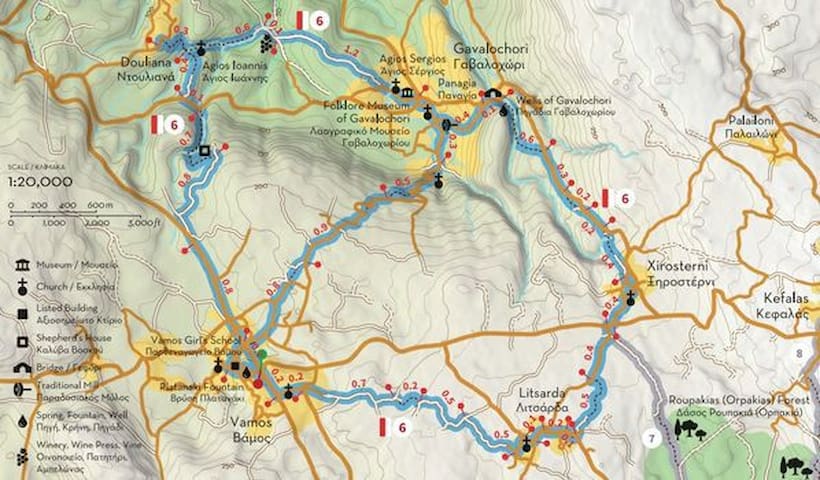
Apokoronos
ROUTE 6 Part2
“At the outskirts of the historic capital of Apokoronas”
PART B
Gavalochori - Xirosterni - Litsarda - Vamos
Part B of Route 6 starts from the central square of Gavalochori, where Part A ends. From here move east (and uphill) for about 600 meters to one of the most beautiful and well hidden “secrets” of the village, Gavaliana Pigadia, a complex of thirty stone tanks of the Venetian era, from where locals used to get water. From the wells move south and then southeast for about 600 meters, meeting the road that connects Gavalochori to Xirosterni at the location Kournedes. Continue southeast along the road for about 300 meters and a little further away turn right into a path that becomes a dirt road (for 200 meters) and then rejoins the main road. About 200 meters away there is a second detour that leads to the northern entrance of Xirosterni (400 meters).
Xirosterni has many interesting examples of folk architecture, while two of its houses have been designated as historic monuments. At the center of the village you will find the church of the Transfiguration of the Savior (Metamorfosi tou Sotiros), which has an impressive wood-carved iconostasis and celebrates on August 6, when a large festival takes place, which has been established as one of the most famous in Apokoronas. Continuing to the southwest entrance of the village, 90 meters away you will see a monument dedicated to the most famous child of the village, the legendary lyra player Charilaos Piperakis, who was born in Xirosterni in 1895 and immigrated to the United States in 1911, where he spread Cretan music to expatriate Greeks and foreigners alike. About 100 meters away, you should meet the provincial road that connects Vamos to Kefalas, where you will turn first right (west) and then left (south) to Litsarda.
About 400 meters after the junction you will turn left (southeast) on a dirt road that leads to the eastern end of Litsarda (after 500 meters). The village was first mentioned at a 1637 church census as Lizzarda, which means lizard. Although the older houses of the settlement have been altered over time, many of their older architectural features are preserved, while the church of Panagia, in the center of the village, has an impressive wood-carved iconostasis and remarkable icons made by Ioannis Aligizakis. From the church of Panagia continue south, turning right (west) at the first intersection and left at the next one, 500 meters away. About 500 meters away this dirt road becomes a path (for 200 meters) and once more a dirt road, which leads to the eastern end of Vamos (after 700 meters).
From here, cross the vertical road and continue west to the forest of Vamos (190 meters), turning right (north) on the main road and descending to the main square (200 meters), returning to the starting point of Part A and completing the circular Route 6.
ATTENTION: Please note that the construction of the trails is in progress and the trails will not be accessible and completely safe until the delivery of the project in the summer of 2022.
Total length of Part B: 6.5 km, estimated time 2h 30΄
Total length of Route 6: 12 km, estimated time 4h 40΄
Map's Address:
https://scontent.fath7-1.fna.fbcdn.net/v/t39.30808-6/272536580_296711252492288_126768738698634784_n.jpg?stp=dst-jpg_p235x350&_nc_cat=109&ccb=1-6&_nc_sid=730e14&_nc_ohc=5jh4LFUz-JsAX-haaMi&_nc_ht=scontent.fath7-1.fna&oh=00_AT9kwaLIMiOUYIt7beddpFFmZwYhsxKsdsCRdf5Y9JtFHg&oe=627DB83F
ROUTE 7
“The enchanted forest”
Xirosterni - Roupakias Forest - Souri - Sellia
Route 7 starts from Xirosterni, a picturesque village in the hinterland of Apokoronas that serves as a connection point with Route 6 (described in the previous two notifications) and ends at Sellia, which serves as a connection point with Route 8 (which connects all the villages between Georgioupoli and Kefalas). From the center of Xirosterni and the church of Metamorfosi tou Sotiros (Transfiguration of the Savior) walk towards the southwestern entrance of the village, on the provincial road Vamos - Kefalas, where you will turn first right (west) and then left (south) to Litsarda.
About 65 meters away turn left (east), leaving behind the common part with Route 6. From here, the route continues slightly uphill for 500 meters and then starts to descend towards Roupakias Forest. At the first junction you will encounter turn right (southwest) and then left (southeast) at the next one, near the point where the dirt road ends and narrows into a path. A little further on you will find a carved stone tank (gourna), an indication you have entered the forest. Roupakias Forest (also known as Orpakias among the locals) occupies most of the plateau between the villages of Kefalas, Xirosterni, Litsarda, Souri, Sellia and Likotinara, which doesn’t have a natural outflow to the sea. In the past the inhabitants of the surrounding villages resorted to the forest for timber and water, but respecting the environment and making limited use of its natural resources. At the same time, they opened several paths, which we hope to maintain and preserve through the Network of Trails of Apokoronas. About 350 meters after the first stone tank you met, the path meets a dirt road, which you will follow (south) for a while, as it becomes a path again. A little further down you will meet a second carved tank and gradually you will start ascending to Souri, which is 800 meters away (and 40 meters higher).
Souri is a small village that extends mostly to the north of the road that connects Litsarda with Sellia, and several of its houses overlook Kefalas, Drapanokefala and the Bay of Souda. To the south of the road, near the western entrance of the village, one can find the church of Agios Ioannis Theologos, which was built in 1910 by a crew under Elias Liodakis. In order to build this church, they had to demolish the previous one, which had been built in 1550, but the villagers saved the original inscription and incorporated it at a warehouse built next to the church.
From Souri continue east along the paved road to Sellia, another beautiful village of the area, built at the eastern end of the Vamos hills near a mountain pass, which is called “seli” in the Cretan dialect. The village is not mentioned in the censuses of the Venetian period, therefore it is estimated it was founded during the Ottoman period. Although the houses of Sellia are scattered, many are excellent examples of folk architecture, while some have been repaired and maintained in good condition. The church of the village is dedicated to Agio Pnevma (the Holy Spirit) and was built in the early 19th century, while further south the road leads to the Ganade hill, which has a panoramic view to the valley of Vrissianos - Almiros in the south, as well as to Drapanokefala to the north. From here you can return by road to Vamos or Xirosterni, or continue on to one of the paths of Route 8, towards Kefalas or Georgioupoli.
Total length of Route 7: 2.7 km, estimated time 1h 50΄
ATTENTION: Please note that the construction of the trails is in progress and the trails will not be accessible and completely safe until the delivery of the project in the summer of 2022.
Map's Address:
https://scontent.fath7-1.fna.fbcdn.net/v/t39.30808-6/272893482_300834845413262_3174448554949633971_n.jpg?stp=dst-jpg_p370x247&_nc_cat=111&ccb=1-6&_nc_sid=730e14&_nc_ohc=90tXzF59NL4AX_EojEZ&tn=KUm263f-4cN_XDu8&_nc_ht=scontent.fath7-1.fna&oh=00_AT-_s87Lih3zk3eQeLg2oUk6Z8cI3W6U0957_Qvxt3Lm5A&oe=627D5A0E
21 Einheimische empfehlen
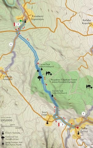
Apokoronos
ROUTE 7
“The enchanted forest”
Xirosterni - Roupakias Forest - Souri - Sellia
Route 7 starts from Xirosterni, a picturesque village in the hinterland of Apokoronas that serves as a connection point with Route 6 (described in the previous two notifications) and ends at Sellia, which serves as a connection point with Route 8 (which connects all the villages between Georgioupoli and Kefalas). From the center of Xirosterni and the church of Metamorfosi tou Sotiros (Transfiguration of the Savior) walk towards the southwestern entrance of the village, on the provincial road Vamos - Kefalas, where you will turn first right (west) and then left (south) to Litsarda.
About 65 meters away turn left (east), leaving behind the common part with Route 6. From here, the route continues slightly uphill for 500 meters and then starts to descend towards Roupakias Forest. At the first junction you will encounter turn right (southwest) and then left (southeast) at the next one, near the point where the dirt road ends and narrows into a path. A little further on you will find a carved stone tank (gourna), an indication you have entered the forest. Roupakias Forest (also known as Orpakias among the locals) occupies most of the plateau between the villages of Kefalas, Xirosterni, Litsarda, Souri, Sellia and Likotinara, which doesn’t have a natural outflow to the sea. In the past the inhabitants of the surrounding villages resorted to the forest for timber and water, but respecting the environment and making limited use of its natural resources. At the same time, they opened several paths, which we hope to maintain and preserve through the Network of Trails of Apokoronas. About 350 meters after the first stone tank you met, the path meets a dirt road, which you will follow (south) for a while, as it becomes a path again. A little further down you will meet a second carved tank and gradually you will start ascending to Souri, which is 800 meters away (and 40 meters higher).
Souri is a small village that extends mostly to the north of the road that connects Litsarda with Sellia, and several of its houses overlook Kefalas, Drapanokefala and the Bay of Souda. To the south of the road, near the western entrance of the village, one can find the church of Agios Ioannis Theologos, which was built in 1910 by a crew under Elias Liodakis. In order to build this church, they had to demolish the previous one, which had been built in 1550, but the villagers saved the original inscription and incorporated it at a warehouse built next to the church.
From Souri continue east along the paved road to Sellia, another beautiful village of the area, built at the eastern end of the Vamos hills near a mountain pass, which is called “seli” in the Cretan dialect. The village is not mentioned in the censuses of the Venetian period, therefore it is estimated it was founded during the Ottoman period. Although the houses of Sellia are scattered, many are excellent examples of folk architecture, while some have been repaired and maintained in good condition. The church of the village is dedicated to Agio Pnevma (the Holy Spirit) and was built in the early 19th century, while further south the road leads to the Ganade hill, which has a panoramic view to the valley of Vrissianos - Almiros in the south, as well as to Drapanokefala to the north. From here you can return by road to Vamos or Xirosterni, or continue on to one of the paths of Route 8, towards Kefalas or Georgioupoli.
Total length of Route 7: 2.7 km, estimated time 1h 50΄
ATTENTION: Please note that the construction of the trails is in progress and the trails will not be accessible and completely safe until the delivery of the project in the summer of 2022.
Map's Address:
https://scontent.fath7-1.fna.fbcdn.net/v/t39.30808-6/272893482_300834845413262_3174448554949633971_n.jpg?stp=dst-jpg_p370x247&_nc_cat=111&ccb=1-6&_nc_sid=730e14&_nc_ohc=90tXzF59NL4AX_EojEZ&tn=KUm263f-4cN_XDu8&_nc_ht=scontent.fath7-1.fna&oh=00_AT-_s87Lih3zk3eQeLg2oUk6Z8cI3W6U0957_Qvxt3Lm5A&oe=627D5A0E
ROUTE 8Part1
“Contrasting landscapes"
Part A
Georgioupolis - Argyromouri - Agios Dimitrios (Katouna) - Sellia - Kefalas
Route 8 starts from Georgioupolis, a seaside town built by the Gulf of Almyros, next to the point where the river with the same name meets the sea. The city was named after Prince George of Greece, High Commissioner of Crete during the period 1898-1906. Apart from the long sandy beaches that extend eastwards all the way to Petres River, some other remarkable points of interest are the church of Ag. Nikolaos, built on a small island that was later connected with a pier to the mainland, and the bridge over Almyros River, to the northeast of which you will find Kalyvaki beach. At the north end of this beach there is another bridge over the mouth of the river Vlychada, to the east of which you can visit the picturesque church of Agia Kyriaki and a bunker built during the German occupation (1941-1945) in order to control the entrance of the port of Georgioupolis. From the bridge of Vlychada the path moves west -and uphill- to Argyromouri (1.1 km), passing by a lime kiln and some places with great views to the sea. Arriving at Argyromouri, make a short stop at the church of Agios Georgios and continue to Exopoli (600 meters), in order to admire its old houses and visit the church of the Assumption of the Virgin and Agios Dimitrios, which has the extremely rare characteristic that it has one aisle and one dome, but two sanctuary niches. Then continue north to Agios Dimitrios - Katouna (700 meters), from where an uphill path leads you to Sellia (2.2 km).
Sellia has probably taken its name from the plural of the Cretan word “selli”, which means “mountain pass”. The houses of the settlement are scattered, but many are excellent examples of folk architecture, while some have been repaired and are maintained in good condition. The church of the village is dedicated to Agio Pnevma (the Holy Spirit) and was built in the early 19th century, while further south the road leads to the Ganade hill, where the Ottomans built a tower and the Germans dug an underground shelter. About 260 meters after the junction where the old café of the village used to be, turn left (north) and again right (northeast) at the first fork after 200 meters, following a path that crosses the eastern part of the Roupakias Forest.
About 900 meters away, the path gradually widens to a dirt road, but after 150 meters turn right (north), following a path that ends 400 meters away at a paved road to Kefalas, one of the largest and most important villages of Municipal Unit of Vamos. Here it is worth walking through the old alleys of the village and visiting some of its many churches, the oldest of which is Timios Stavros (the Holy Cross), built in the 16th century. Some of the newer churches are also of particular interest, as in the case of Panagia, Agios Antonios and Michael Archangelos, exquisite examples of local religious architecture of the 18th and 19th centuries. The same local craftsmen built the Primary School of Kefalas, which today houses the Center for Environmental Education of Vamos, next to which you can find a small folklore museum, which exhibits samples of textile art and household utensils and tools of bygone eras.
From Kefalas you can return by road to Georgioupolis (10 km) or “refuel” and continue to Part B of Route 8, with the same destination.
Total length of Part A: 7.7 km, estimated time 3h 40΄
Total length of Route 8: 15.6 km, estimated time 7h 05΄
ATTENTION: Please note that the construction of the trails is in progress and the trails will not be accessible and completely safe until the delivery of the project in the summer of 2022.
Map's Address:
https://scontent.fath7-1.fna.fbcdn.net/v/t39.30808-6/273600240_305717814924965_4163312378190307174_n.jpg?stp=dst-jpg_s600x600&_nc_cat=107&ccb=1-6&_nc_sid=730e14&_nc_ohc=I6Rml_T_tVkAX8bxfcJ&_nc_ht=scontent.fath7-1.fna&oh=00_AT946mAr6pI6hojXzaQWqa-1mwyoa_itaaizjr5c56LRLQ&oe=627D8251
21 Einheimische empfehlen
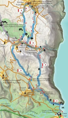
Apokoronos
ROUTE 8Part1
“Contrasting landscapes"
Part A
Georgioupolis - Argyromouri - Agios Dimitrios (Katouna) - Sellia - Kefalas
Route 8 starts from Georgioupolis, a seaside town built by the Gulf of Almyros, next to the point where the river with the same name meets the sea. The city was named after Prince George of Greece, High Commissioner of Crete during the period 1898-1906. Apart from the long sandy beaches that extend eastwards all the way to Petres River, some other remarkable points of interest are the church of Ag. Nikolaos, built on a small island that was later connected with a pier to the mainland, and the bridge over Almyros River, to the northeast of which you will find Kalyvaki beach. At the north end of this beach there is another bridge over the mouth of the river Vlychada, to the east of which you can visit the picturesque church of Agia Kyriaki and a bunker built during the German occupation (1941-1945) in order to control the entrance of the port of Georgioupolis. From the bridge of Vlychada the path moves west -and uphill- to Argyromouri (1.1 km), passing by a lime kiln and some places with great views to the sea. Arriving at Argyromouri, make a short stop at the church of Agios Georgios and continue to Exopoli (600 meters), in order to admire its old houses and visit the church of the Assumption of the Virgin and Agios Dimitrios, which has the extremely rare characteristic that it has one aisle and one dome, but two sanctuary niches. Then continue north to Agios Dimitrios - Katouna (700 meters), from where an uphill path leads you to Sellia (2.2 km).
Sellia has probably taken its name from the plural of the Cretan word “selli”, which means “mountain pass”. The houses of the settlement are scattered, but many are excellent examples of folk architecture, while some have been repaired and are maintained in good condition. The church of the village is dedicated to Agio Pnevma (the Holy Spirit) and was built in the early 19th century, while further south the road leads to the Ganade hill, where the Ottomans built a tower and the Germans dug an underground shelter. About 260 meters after the junction where the old café of the village used to be, turn left (north) and again right (northeast) at the first fork after 200 meters, following a path that crosses the eastern part of the Roupakias Forest.
About 900 meters away, the path gradually widens to a dirt road, but after 150 meters turn right (north), following a path that ends 400 meters away at a paved road to Kefalas, one of the largest and most important villages of Municipal Unit of Vamos. Here it is worth walking through the old alleys of the village and visiting some of its many churches, the oldest of which is Timios Stavros (the Holy Cross), built in the 16th century. Some of the newer churches are also of particular interest, as in the case of Panagia, Agios Antonios and Michael Archangelos, exquisite examples of local religious architecture of the 18th and 19th centuries. The same local craftsmen built the Primary School of Kefalas, which today houses the Center for Environmental Education of Vamos, next to which you can find a small folklore museum, which exhibits samples of textile art and household utensils and tools of bygone eras.
From Kefalas you can return by road to Georgioupolis (10 km) or “refuel” and continue to Part B of Route 8, with the same destination.
Total length of Part A: 7.7 km, estimated time 3h 40΄
Total length of Route 8: 15.6 km, estimated time 7h 05΄
ATTENTION: Please note that the construction of the trails is in progress and the trails will not be accessible and completely safe until the delivery of the project in the summer of 2022.
Map's Address:
https://scontent.fath7-1.fna.fbcdn.net/v/t39.30808-6/273600240_305717814924965_4163312378190307174_n.jpg?stp=dst-jpg_s600x600&_nc_cat=107&ccb=1-6&_nc_sid=730e14&_nc_ohc=I6Rml_T_tVkAX8bxfcJ&_nc_ht=scontent.fath7-1.fna&oh=00_AT946mAr6pI6hojXzaQWqa-1mwyoa_itaaizjr5c56LRLQ&oe=627D8251
ROUTE 8Part2
“Contrasting landscapes"
Part Β
Kefalas - Roupakias Forest - Likotinara - Agia Kyriaki - Georgioupolis
Part B of Route 8 is as interesting as A, but it has the additional advantage that many parts of it overlook the Gulf of Almyros to the east of Apokoronas. From the main square of Kato (Lower) Kefalas head to Ano Kefalas (Upper), where you will find many old houses and churches. During the Venetian occupation, Ano and Kato Kefalas were two distinct villages, which became one over time (administratively by the mid-20th century). About 190 meters to the southeast you will find the church of Archangelos Michail, an excellent example of 18th century folk architecture. Continue south on the same road, turn left at its end and right (southwest) at the next junction.
A little further away the road becomes a dirt road, on which you will continue for another 400 meters. Near its end, turn left (south) at the marked path, which leads to the eastern end of the Roupakias Forest 500 meters away. Cross the next dirt road vertically and continue on the same path, which broadens into a dirt road as you ascend. You should see a vineyard on your right (west) and after a while you will reach the road that connects Sellia to Likotinara. From here, you can continue right (west) to Sellia and return again to Kefalas, or continue to Georgioupolis (see Part A) or turn left (east) and reach Likotinara after 500 meters.
Likotinara is built at an altitude of 290 meters at the eastern end of the Vamos hills, just south of (or opposite) the Kefalas hills. Due to its location, the village has excellent views to the Gulf of Almyros, and on a clear day you can see much of the provinces of Rethymno and Mylopotamos, as well as Kouloukonas (Mount Talos of antiquity) and Psiloritis (Mount Ida). The slope below the village has several palm trees, which have given the site the name Vayonia. Locals do not know how these tropical trees grew there, but it is likely that their seeds were transported by migratory birds which pass through this area every year, traveling from and to Africa. The area east of the village is known as “Gremna” (cliffs) and is a protected ecosystem under the Natura 2000 Network, at the boundaries of which you will continue moving south. From the view point turn back (north) for 40 meters and then turn left (west) on the uphill road to the highest houses. Turn left at the next junction after 400 meters and continue south on the same dirt road along the ridge of the hills, turning right (southwest) at the lime kiln you will encounter after 600 meters. Here the dirt road becomes a path that descends sharply, offering excellent views of the Gulf of Almyros and the coast east of Georgioupolis.
About 1.1 km below you will reach Argyromouri (again), from where you can follow the same path you climbed from Vlychada bridge and get to Kalyvaki beach and the center of Georgioupolis.
Total length of Part B: 7.4 km, estimated time 3h 25΄
Total length of Route 8: 15.6 km, estimated time 7h 05΄
ATTENTION: Please note that the construction of the trails is in progress and the trails will not be accessible and completely safe until the delivery of the project in the summer of 2022.
Map's Address:
https://scontent.fath7-1.fna.fbcdn.net/v/t39.30808-6/273915370_309500767880003_659116775184422510_n.jpg?stp=dst-jpg_s600x600&_nc_cat=109&ccb=1-6&_nc_sid=730e14&_nc_ohc=OcZD-W_a5FkAX_LqXYo&tn=KUm263f-4cN_XDu8&_nc_ht=scontent.fath7-1.fna&oh=00_AT91LR9Pi7SSPixPkd5rANbnLcFTyEFy8BSABxx_mDvfjg&oe=627EC39B
21 Einheimische empfehlen

Apokoronos
ROUTE 8Part2
“Contrasting landscapes"
Part Β
Kefalas - Roupakias Forest - Likotinara - Agia Kyriaki - Georgioupolis
Part B of Route 8 is as interesting as A, but it has the additional advantage that many parts of it overlook the Gulf of Almyros to the east of Apokoronas. From the main square of Kato (Lower) Kefalas head to Ano Kefalas (Upper), where you will find many old houses and churches. During the Venetian occupation, Ano and Kato Kefalas were two distinct villages, which became one over time (administratively by the mid-20th century). About 190 meters to the southeast you will find the church of Archangelos Michail, an excellent example of 18th century folk architecture. Continue south on the same road, turn left at its end and right (southwest) at the next junction.
A little further away the road becomes a dirt road, on which you will continue for another 400 meters. Near its end, turn left (south) at the marked path, which leads to the eastern end of the Roupakias Forest 500 meters away. Cross the next dirt road vertically and continue on the same path, which broadens into a dirt road as you ascend. You should see a vineyard on your right (west) and after a while you will reach the road that connects Sellia to Likotinara. From here, you can continue right (west) to Sellia and return again to Kefalas, or continue to Georgioupolis (see Part A) or turn left (east) and reach Likotinara after 500 meters.
Likotinara is built at an altitude of 290 meters at the eastern end of the Vamos hills, just south of (or opposite) the Kefalas hills. Due to its location, the village has excellent views to the Gulf of Almyros, and on a clear day you can see much of the provinces of Rethymno and Mylopotamos, as well as Kouloukonas (Mount Talos of antiquity) and Psiloritis (Mount Ida). The slope below the village has several palm trees, which have given the site the name Vayonia. Locals do not know how these tropical trees grew there, but it is likely that their seeds were transported by migratory birds which pass through this area every year, traveling from and to Africa. The area east of the village is known as “Gremna” (cliffs) and is a protected ecosystem under the Natura 2000 Network, at the boundaries of which you will continue moving south. From the view point turn back (north) for 40 meters and then turn left (west) on the uphill road to the highest houses. Turn left at the next junction after 400 meters and continue south on the same dirt road along the ridge of the hills, turning right (southwest) at the lime kiln you will encounter after 600 meters. Here the dirt road becomes a path that descends sharply, offering excellent views of the Gulf of Almyros and the coast east of Georgioupolis.
About 1.1 km below you will reach Argyromouri (again), from where you can follow the same path you climbed from Vlychada bridge and get to Kalyvaki beach and the center of Georgioupolis.
Total length of Part B: 7.4 km, estimated time 3h 25΄
Total length of Route 8: 15.6 km, estimated time 7h 05΄
ATTENTION: Please note that the construction of the trails is in progress and the trails will not be accessible and completely safe until the delivery of the project in the summer of 2022.
Map's Address:
https://scontent.fath7-1.fna.fbcdn.net/v/t39.30808-6/273915370_309500767880003_659116775184422510_n.jpg?stp=dst-jpg_s600x600&_nc_cat=109&ccb=1-6&_nc_sid=730e14&_nc_ohc=OcZD-W_a5FkAX_LqXYo&tn=KUm263f-4cN_XDu8&_nc_ht=scontent.fath7-1.fna&oh=00_AT91LR9Pi7SSPixPkd5rANbnLcFTyEFy8BSABxx_mDvfjg&oe=627EC39B
ROUTE 9
“The lake tour”
Lake Kournas (Μouri / Kavallos) - Delfinas bridge - Klima - Mati spring
Lake Kournas is one of the most popular points of interest in Crete, and consequently one that could not be left out of the network of trails of Apokoronas. It is the largest natural lake in Crete and the largest natural lake on an island in the Mediterranean, but its beauty is not related to its uniqueness. In ancient times the lake was known as Korissia and archeologists believe there used to be a sanctuary dedicated to Athena Korissia on its banks. The name “Kournas” is probably connected to the Arab occupation of Crete (early 8th century - 961 AD), as “kourna” or “gourna” means lake in Arabic. The lake’s dimensions change over the year, but its maximum area reaches 579 acres and its volume is 7.5 million cubic meters. The lake is an important habitat for fish and migratory birds, and has been designated as a Bird Conservation Area that has been included in the Natura 2000 network.
Route 9 starts from the east shore of the lake, where visitors can find many cafés and restaurants. On the east side of the road to Georgioupolis you can find the settlement of Mouri, while Kavallos is situated a bit further south. Once you meet the lake walk north along its east bank, turning left into a path that passes next to (left of) the last cafeteria at its north end. A few meters above you will find a small metal bridge, under which passes the river Delfinas, which flows into the Gulf of Almyros a few kilometers away, between Asproulianos and Kavros.
Cross over the bridge and follow the river back to the lake (heading southwest). Continue westwards and at a distance of about 300 meters you will encounter a dirt road, on which you should turn left (south) and continue walking along the west bank of the lake. This dirt road starts to climb after about 800 meters, but continue to the point where it ends (500 meters away) and narrows to a small uphill path. This path leads you after 1.3 km to Klima Alikambou, a historic site where the first armed gathering of the Metapoliteftiki Revolution took place on September 3, 1895. During the gathering Manousos Koundouros, a judge in Vamos, read before 1,500 armed men a memorandum that described the demands of the Christians of Crete, which was later sent to the foreign consulates in Chania. During the same revolution the local Sifis Lekanidis (from Alikambos) also played an important role.
From Klima follow the dirt road to the south for about 400 meters, and then look for signage that shows you a path that continues to the south and then east. If you move correctly, after a while you will encounter a plateau with excellent views of the lake, the Gulf of Almyros and the valley of Mousselas, the river separating Apokoronas from Rethimno. Continuing on the same old, built path, some 2.5 km below you will encounter a dirt road that leads to Kavallos and Kournas. Leave this dirt road a few dozen meters below and turn left again (north) towards the lake, in order to reach the spring Mati (“eye”) 500 meters below, the largest natural spring that feeds the lake. From here follow a narrow dirt road that continues along the east bank of the lake (a few meters above it, to be precise) in order to return to the point you had started.
Total length of Route 9: 7.8 km, estimated time 4h 30΄
ATTENTION: Please note that the construction of the trails is in progress and the trails will not be accessible and completely safe until the delivery of the project in the summer of 2022.
Map's Address:
https://scontent.fath7-1.fna.fbcdn.net/v/t39.30808-6/274272674_313428110820602_1389794728515321639_n.jpg?stp=dst-jpg_s600x600&_nc_cat=107&ccb=1-6&_nc_sid=730e14&_nc_ohc=TUh8K7kAcs4AX_taCM5&tn=KUm263f-4cN_XDu8&_nc_ht=scontent.fath7-1.fna&oh=00_AT--lwdNKK8U4Y7uVZwjkpepusdF6x_bwy-0mmS0QoZ8pg&oe=627D4C97
21 Einheimische empfehlen
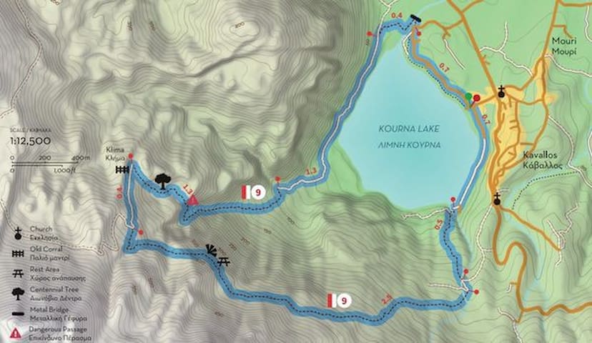
Apokoronos
ROUTE 9
“The lake tour”
Lake Kournas (Μouri / Kavallos) - Delfinas bridge - Klima - Mati spring
Lake Kournas is one of the most popular points of interest in Crete, and consequently one that could not be left out of the network of trails of Apokoronas. It is the largest natural lake in Crete and the largest natural lake on an island in the Mediterranean, but its beauty is not related to its uniqueness. In ancient times the lake was known as Korissia and archeologists believe there used to be a sanctuary dedicated to Athena Korissia on its banks. The name “Kournas” is probably connected to the Arab occupation of Crete (early 8th century - 961 AD), as “kourna” or “gourna” means lake in Arabic. The lake’s dimensions change over the year, but its maximum area reaches 579 acres and its volume is 7.5 million cubic meters. The lake is an important habitat for fish and migratory birds, and has been designated as a Bird Conservation Area that has been included in the Natura 2000 network.
Route 9 starts from the east shore of the lake, where visitors can find many cafés and restaurants. On the east side of the road to Georgioupolis you can find the settlement of Mouri, while Kavallos is situated a bit further south. Once you meet the lake walk north along its east bank, turning left into a path that passes next to (left of) the last cafeteria at its north end. A few meters above you will find a small metal bridge, under which passes the river Delfinas, which flows into the Gulf of Almyros a few kilometers away, between Asproulianos and Kavros.
Cross over the bridge and follow the river back to the lake (heading southwest). Continue westwards and at a distance of about 300 meters you will encounter a dirt road, on which you should turn left (south) and continue walking along the west bank of the lake. This dirt road starts to climb after about 800 meters, but continue to the point where it ends (500 meters away) and narrows to a small uphill path. This path leads you after 1.3 km to Klima Alikambou, a historic site where the first armed gathering of the Metapoliteftiki Revolution took place on September 3, 1895. During the gathering Manousos Koundouros, a judge in Vamos, read before 1,500 armed men a memorandum that described the demands of the Christians of Crete, which was later sent to the foreign consulates in Chania. During the same revolution the local Sifis Lekanidis (from Alikambos) also played an important role.
From Klima follow the dirt road to the south for about 400 meters, and then look for signage that shows you a path that continues to the south and then east. If you move correctly, after a while you will encounter a plateau with excellent views of the lake, the Gulf of Almyros and the valley of Mousselas, the river separating Apokoronas from Rethimno. Continuing on the same old, built path, some 2.5 km below you will encounter a dirt road that leads to Kavallos and Kournas. Leave this dirt road a few dozen meters below and turn left again (north) towards the lake, in order to reach the spring Mati (“eye”) 500 meters below, the largest natural spring that feeds the lake. From here follow a narrow dirt road that continues along the east bank of the lake (a few meters above it, to be precise) in order to return to the point you had started.
Total length of Route 9: 7.8 km, estimated time 4h 30΄
ATTENTION: Please note that the construction of the trails is in progress and the trails will not be accessible and completely safe until the delivery of the project in the summer of 2022.
Map's Address:
https://scontent.fath7-1.fna.fbcdn.net/v/t39.30808-6/274272674_313428110820602_1389794728515321639_n.jpg?stp=dst-jpg_s600x600&_nc_cat=107&ccb=1-6&_nc_sid=730e14&_nc_ohc=TUh8K7kAcs4AX_taCM5&tn=KUm263f-4cN_XDu8&_nc_ht=scontent.fath7-1.fna&oh=00_AT--lwdNKK8U4Y7uVZwjkpepusdF6x_bwy-0mmS0QoZ8pg&oe=627D4C97
ROUTE 10
“Dafnomadara and Azilakas Forest”
Kournas - Agios Ioannis - Patima - Kastellos - Azilakas Forest (Koumares)
Route 10 is one of the most beautiful nature-loving routes of Apokoronas, which combines the lush Forest of Azilakas with the peaks of Dafnomadara (part of the mighty Lefka Ori) and the picturesque villages of Kournas, Kastellos and Patima. The route starts from the central square of the village of Kournas, which is estimated to have been founded or moved to its current location during the second Byzantine period (961-1252), as archeologic excavations in the churches of Agios Georgios and Agia Irini have revealed some interesting Byzantine frescoes in good condition (in some places there are up to four successive layers, with the oldest dating back to the 12th century). The oldest written reference to Kournas is made in an attorney certificate of 1356, and since then it is continuously mentioned by the Venetian censuses. During the 1866-1869 revolution Kournas became the seat of the Revolutionary Government for a period, and the temporary seat of the Cretan Assembly during the 1897 revolution.
From the central square of Kournas move southwest (and uphill) to the southern end of the settlement, shortly after which you will encounter an inverted Ψ-like crossroads. Follow the right (west) branch and walk 500 meters to the next fork, where you will turn left (southeast). About 600 meters above you will find another crossroads, where you can turn left (north) to visit the chapel of Agios Ioannis (next to which there’s a spring), or continue right (east) to Dafnomadara, the north end of Mount Omanite, on the eastern tip of the White Mountains (Lefka Ori). About 700 meters away you’ll reach another fork, where you have two options: one is to turn left (north) and head to Kastellos or Kournas through the Azilakas Forest (the forest starts after 400 meters) and the other is to turn right (east), following the path to Agios Antonios (1 km away) and the village of Patima (another 1 km from there).
Patima is a small village built on a hill with excellent views to Kastellos, the Gulf of Almyros and the plain of Episkopi. The origin of its name is not known (it means “step” in Greek), but it is estimated it was founded during the Venetian rule, when it was chosen as seat of a garrison. The village is historically connected with the villages of Kastellos and Kournas, which has led to the three villages being commonly named as “Kournopatimata”. After touring the settlement, the path leads you to the church of Christos, 300 meters northwest of the village.
From here walk slightly uphill to Kastellos, in the center and highest point of which you will find the church of Agios Nikolaos. The original settlement was built at the northern end of the hill, in a location called Agathés or Agathiás, but during the Venetian rule the hill was fortified and used as a castle (castello), hence its name. Some significant battles took place in and around the village in 1821 and 1835, while Kastellos also played an important role during the German occupation (1941-1945), when it became a temporary refuge for guerrilla groups.
From Kastellos head west to the impressive Azilakas Forest, which took its name from a tree that has the same name, an endemic species of oak that can reach up to 25 meters in height and whose leaves look like those of the olive tree. After reaching the bottom of the valley, at a distance of about 1 km from Kastellos, turn right (north) towards Kournas, where you will reach after 1.5 km of lush and impressive landscape.
Total length of Route 10: 7.6 km, estimated time 3h 55΄
ATTENTION: Please note that the construction of the trails is in progress and the trails will not be accessible and completely safe until the delivery of the project in the summer of 2022.
Map's Address:
https://scontent.fath7-1.fna.fbcdn.net/v/t39.30808-6/274882585_317937180369695_6225920135453913160_n.jpg?stp=dst-jpg_s600x600&_nc_cat=105&ccb=1-6&_nc_sid=730e14&_nc_ohc=kyJdCVLad5cAX8bP8K0&_nc_ht=scontent.fath7-1.fna&oh=00_AT-nS31QrHEJ_8YG9V5AL-DbReCoHgFFFVUpt2IYq1i4ig&oe=627E3867
21 Einheimische empfehlen
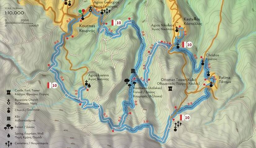
Apokoronos
ROUTE 10
“Dafnomadara and Azilakas Forest”
Kournas - Agios Ioannis - Patima - Kastellos - Azilakas Forest (Koumares)
Route 10 is one of the most beautiful nature-loving routes of Apokoronas, which combines the lush Forest of Azilakas with the peaks of Dafnomadara (part of the mighty Lefka Ori) and the picturesque villages of Kournas, Kastellos and Patima. The route starts from the central square of the village of Kournas, which is estimated to have been founded or moved to its current location during the second Byzantine period (961-1252), as archeologic excavations in the churches of Agios Georgios and Agia Irini have revealed some interesting Byzantine frescoes in good condition (in some places there are up to four successive layers, with the oldest dating back to the 12th century). The oldest written reference to Kournas is made in an attorney certificate of 1356, and since then it is continuously mentioned by the Venetian censuses. During the 1866-1869 revolution Kournas became the seat of the Revolutionary Government for a period, and the temporary seat of the Cretan Assembly during the 1897 revolution.
From the central square of Kournas move southwest (and uphill) to the southern end of the settlement, shortly after which you will encounter an inverted Ψ-like crossroads. Follow the right (west) branch and walk 500 meters to the next fork, where you will turn left (southeast). About 600 meters above you will find another crossroads, where you can turn left (north) to visit the chapel of Agios Ioannis (next to which there’s a spring), or continue right (east) to Dafnomadara, the north end of Mount Omanite, on the eastern tip of the White Mountains (Lefka Ori). About 700 meters away you’ll reach another fork, where you have two options: one is to turn left (north) and head to Kastellos or Kournas through the Azilakas Forest (the forest starts after 400 meters) and the other is to turn right (east), following the path to Agios Antonios (1 km away) and the village of Patima (another 1 km from there).
Patima is a small village built on a hill with excellent views to Kastellos, the Gulf of Almyros and the plain of Episkopi. The origin of its name is not known (it means “step” in Greek), but it is estimated it was founded during the Venetian rule, when it was chosen as seat of a garrison. The village is historically connected with the villages of Kastellos and Kournas, which has led to the three villages being commonly named as “Kournopatimata”. After touring the settlement, the path leads you to the church of Christos, 300 meters northwest of the village.
From here walk slightly uphill to Kastellos, in the center and highest point of which you will find the church of Agios Nikolaos. The original settlement was built at the northern end of the hill, in a location called Agathés or Agathiás, but during the Venetian rule the hill was fortified and used as a castle (castello), hence its name. Some significant battles took place in and around the village in 1821 and 1835, while Kastellos also played an important role during the German occupation (1941-1945), when it became a temporary refuge for guerrilla groups.
From Kastellos head west to the impressive Azilakas Forest, which took its name from a tree that has the same name, an endemic species of oak that can reach up to 25 meters in height and whose leaves look like those of the olive tree. After reaching the bottom of the valley, at a distance of about 1 km from Kastellos, turn right (north) towards Kournas, where you will reach after 1.5 km of lush and impressive landscape.
Total length of Route 10: 7.6 km, estimated time 3h 55΄
ATTENTION: Please note that the construction of the trails is in progress and the trails will not be accessible and completely safe until the delivery of the project in the summer of 2022.
Map's Address:
https://scontent.fath7-1.fna.fbcdn.net/v/t39.30808-6/274882585_317937180369695_6225920135453913160_n.jpg?stp=dst-jpg_s600x600&_nc_cat=105&ccb=1-6&_nc_sid=730e14&_nc_ohc=kyJdCVLad5cAX8bP8K0&_nc_ht=scontent.fath7-1.fna&oh=00_AT-nS31QrHEJ_8YG9V5AL-DbReCoHgFFFVUpt2IYq1i4ig&oe=627E3867
ROUTE 11
“On the hills”
Asi Gonia - Potistiria - Dafnomadara - Kato Agori - Asfendilides
Route 11 connects the picturesque and historic village of Asi Gonia with the highest and wildest side of Dafnomadara, part of Mount Omanite (altitude 1,184 meters) at the east end of the White Mountains (Lefka Ori). The route starts and ends at Asi Gonia, which is located at an altitude of 418 meters at the southeastern end of Apokoronas. Due to the location of the village at the bottom of the Asigoniotiko gorge, the settlement was initially named Gonia (corner), a name that was later changed to Asi Gonia, in order to reflect the unruly character of its inhabitants (“asi” in Turkish means disobedient, rebel). True to its name, the village played an important role during the struggles of the Christians of Crete against the Ottomans. In August 1866 the Pancretan Revolutionary Assembly met in Asi Gonia, while in February 1867 the “Provisional Government of Crete” moved here, as also happened during the 1895-1896 revolution. Asi Gonia also played a prominent role during the German occupation and the Resistance (1941-1945).
From the main square of the village move northeast to the Apano Gitonia (upper neighborhood) and the place Potistiria (watering place), where you can find a small museum dedicated to George Psychoundakis - Bertodoulos, also known as “the Cretan runner”, who used to travel huge distances -usually at night- transferring messages from the Middle East Allied Command to Cretan rebel groups and vice versa. From here move east along the road that follows the foot of the mountain, passing north of the local team field (250 meters from the museum) and turning left at the first junction, 450 meters above. Then turn left at the next fork (350 meters) and again left at the second (600 meters above). Here the road becomes a dirt road and then narrows to a path, which ascends to the ridge of Dafnomadara.
After crossing to the north side of the ridge, turn left (southwest) at the first fork you will encounter, in order to reach a small plateau where Mitato (mountain hut) Sbirakis (Yangos) and Mitato Gyparis (Bratzios) are located. From here the path continues north to a point named Vigla, from where you can enjoy excellent views of the valley of river Musselas, Lake Kournas and the Gulf of Almyros. In “front” of you (to the north) at a distance of about two kilometers is the Forest of Azilakas (Route 10) and the villages of Kournas, Kastellos and Patima (from west to east). To the west, your field of vision can reach Dafnokorfi and the hills of Kefalas, and to the east the hills of Petres and the hinterland of Rethymno. From Vigla return to the previous fork and turn left on the same dirt road (right as you came before), descending slightly for 1.4 km to the hill Kato Agori, where the beautiful church of Zoodochos Pigi is located.
From this church return from the same path for 550 meters and then turn left, going up the dirt road to Asfentilides. The path ascends for about 800 meters, and then descends for about 2 km, passing through areas of natural vegetation, olive groves and pastures, offering views from many points to the springs of Argyroupoli opposite (east) and the Asigoniotiko gorge (south), the which is the limit of the prefectures of Chania and Rethymnon. After the 2 km mentioned above, you meet the road you followed from Potistiria and the stadium, which you now follow in reverse to return to Asi Gonia and the main road.
Total length of Route 11: 9 km, estimated time 4h 15΄
ATTENTION: Please note that the construction of the trails is in progress and the trails will not be accessible and completely safe until the delivery of the project in the summer of 2022.
Map's Address:
https://scontent.fath7-1.fna.fbcdn.net/v/t39.30808-6/275380998_322867433210003_7109792436075423669_n.jpg?stp=dst-jpg_s600x600&_nc_cat=107&ccb=1-6&_nc_sid=730e14&_nc_ohc=GxqU2sla0nMAX84Enl6&tn=KUm263f-4cN_XDu8&_nc_ht=scontent.fath7-1.fna&oh=00_AT9B8Xy1lTc-JElNBzwmKOBGj1P-J9WRM6mmdpieySakJA&oe=627DF306
21 Einheimische empfehlen
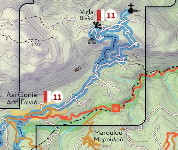
Apokoronos
ROUTE 11
“On the hills”
Asi Gonia - Potistiria - Dafnomadara - Kato Agori - Asfendilides
Route 11 connects the picturesque and historic village of Asi Gonia with the highest and wildest side of Dafnomadara, part of Mount Omanite (altitude 1,184 meters) at the east end of the White Mountains (Lefka Ori). The route starts and ends at Asi Gonia, which is located at an altitude of 418 meters at the southeastern end of Apokoronas. Due to the location of the village at the bottom of the Asigoniotiko gorge, the settlement was initially named Gonia (corner), a name that was later changed to Asi Gonia, in order to reflect the unruly character of its inhabitants (“asi” in Turkish means disobedient, rebel). True to its name, the village played an important role during the struggles of the Christians of Crete against the Ottomans. In August 1866 the Pancretan Revolutionary Assembly met in Asi Gonia, while in February 1867 the “Provisional Government of Crete” moved here, as also happened during the 1895-1896 revolution. Asi Gonia also played a prominent role during the German occupation and the Resistance (1941-1945).
From the main square of the village move northeast to the Apano Gitonia (upper neighborhood) and the place Potistiria (watering place), where you can find a small museum dedicated to George Psychoundakis - Bertodoulos, also known as “the Cretan runner”, who used to travel huge distances -usually at night- transferring messages from the Middle East Allied Command to Cretan rebel groups and vice versa. From here move east along the road that follows the foot of the mountain, passing north of the local team field (250 meters from the museum) and turning left at the first junction, 450 meters above. Then turn left at the next fork (350 meters) and again left at the second (600 meters above). Here the road becomes a dirt road and then narrows to a path, which ascends to the ridge of Dafnomadara.
After crossing to the north side of the ridge, turn left (southwest) at the first fork you will encounter, in order to reach a small plateau where Mitato (mountain hut) Sbirakis (Yangos) and Mitato Gyparis (Bratzios) are located. From here the path continues north to a point named Vigla, from where you can enjoy excellent views of the valley of river Musselas, Lake Kournas and the Gulf of Almyros. In “front” of you (to the north) at a distance of about two kilometers is the Forest of Azilakas (Route 10) and the villages of Kournas, Kastellos and Patima (from west to east). To the west, your field of vision can reach Dafnokorfi and the hills of Kefalas, and to the east the hills of Petres and the hinterland of Rethymno. From Vigla return to the previous fork and turn left on the same dirt road (right as you came before), descending slightly for 1.4 km to the hill Kato Agori, where the beautiful church of Zoodochos Pigi is located.
From this church return from the same path for 550 meters and then turn left, going up the dirt road to Asfentilides. The path ascends for about 800 meters, and then descends for about 2 km, passing through areas of natural vegetation, olive groves and pastures, offering views from many points to the springs of Argyroupoli opposite (east) and the Asigoniotiko gorge (south), the which is the limit of the prefectures of Chania and Rethymnon. After the 2 km mentioned above, you meet the road you followed from Potistiria and the stadium, which you now follow in reverse to return to Asi Gonia and the main road.
Total length of Route 11: 9 km, estimated time 4h 15΄
ATTENTION: Please note that the construction of the trails is in progress and the trails will not be accessible and completely safe until the delivery of the project in the summer of 2022.
Map's Address:
https://scontent.fath7-1.fna.fbcdn.net/v/t39.30808-6/275380998_322867433210003_7109792436075423669_n.jpg?stp=dst-jpg_s600x600&_nc_cat=107&ccb=1-6&_nc_sid=730e14&_nc_ohc=GxqU2sla0nMAX84Enl6&tn=KUm263f-4cN_XDu8&_nc_ht=scontent.fath7-1.fna&oh=00_AT9B8Xy1lTc-JElNBzwmKOBGj1P-J9WRM6mmdpieySakJA&oe=627DF306
ROUTE 12
“The shepherds’ path”
Asi Gonia - Hainospilios - Havidi Poros - Timios Stavros
Route 12 connects Asi Gonia with sites of particular natural beauty and historical value, crossing through a protected area of the European Ecological Network Natura 2000, where 19 habitat types can be found, as well as diktamos (Origanum dictamnus), an endemic species of Crete that can be found in mountain areas with altitude up to 1,600 meters. Similar to Route 11, Route 12 starts from the central square of Asi Gonia, where visitors can find a monument dedicated to the Cretan struggles for freedom and the busts of Pavlos Gyparis, Stylianos Kokkinakis and Michail Meladakis, who distinguished themselves for their action in and outside Crete.
From this square head south for about 70 meters and then turn left, descending to the stream south of the village. The path crosses through the stream and meets the road again after 700 meters (“opposite” the village), where you first turn right (southwest) and after 150 meters left (south) at the first turn, following a path that leads to the interior of a ravine, west of the road to Kallikratis. At a steep point near the southern end of this ravine one can find Hainospilios, the “cave of rebels”, where in December 1868 the members of the Provisional Revolutionary Government of Crete issued a resolution titled “Union (with Greece) or Death”.
Continuing uphill from here you will meet the road again after 200 meters, near the place where the Ottomans built a tower (kule), one of the many that were built after the 1866 revolution in order to control the mountain areas of Crete. From here signs lead you southwest along the road, which you should leave after about 400 meters and continue uphill. Half a kilometer away from here, at Vourvoures, one can find the old house of colonel Andreas Papadakis, a leading member of AEAK (Supreme Committee of the Struggle of Crete), the first armed resistance organization in Crete. The first British radio station was installed here in the autumn of 1941, through which AEAK transmitted valuable information about the German positions and movements to the Middle East Allied Command in Cairo.
The path continues on to the location Havidi Poros and the picturesque church of Agios Ioannis, next to which there is a well-preserved mitato (shepherds’ hut) and a little further another church, dedicated to Agio Pnevma (the Holy Spirit). From here move northwest and then northeast along the ridge for about 1.2 km, where you will find another beautiful chapel dedicated to Timios Stavros (the Holy Cross), with excellent views of Asi Gonia and Mount Omanite above it. From here, descend carefully from the north side of the hill, in order to reach a stream that leads to a dirt road, which widens into a road a little further away and leads you to the central square of Asi Gonia, from where you started.
Depending on the time of the year, it might be worth visiting the church of Ai Giorgis Galatas (St George “the milkman”), where the homonymous custom takes place every year on the feast of Agios Georgios (April 23). On this day the shepherds of the village bring their sheep and goats to the church, where the animals are milked one by one and the herd is blessed by a priest. Subsequently the milk is distributed to the attendees -residents or visitors- either boiled or cold, while at the same time girls dressed in traditional costumes offer Cretan rusks and cheese. Don’t miss it if you are around!
Total length of Route 12: 8.4 km, estimated time 3h 25΄
ATTENTION: Please note that the construction of the trails is in progress and the trails will not be accessible and completely safe until the delivery of the project in the summer of 2022.
This is how this series of notifications on the Paths of Apokoronas ends. Thank you very much for "walking" with us, even if imaginary, and hope to see you in summer in one or more of these routes, in order to meet another aspect of the beauty of Apokoronas!
Map's Address:
https://scontent.fath7-1.fna.fbcdn.net/v/t39.30808-6/275916644_326700976159982_1068532294528429829_n.jpg?stp=dst-jpg_s600x600&_nc_cat=106&ccb=1-6&_nc_sid=730e14&_nc_ohc=eCbCopISCKsAX_4pNwz&_nc_ht=scontent.fath7-1.fna&oh=00_AT_WWdjnCPAi0kL6S_Lt-AItdKXdhYeOsBuGR72JshCGGw&oe=627D3DAA
21 Einheimische empfehlen
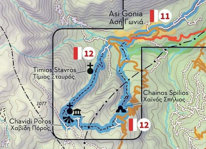
Apokoronos
ROUTE 12
“The shepherds’ path”
Asi Gonia - Hainospilios - Havidi Poros - Timios Stavros
Route 12 connects Asi Gonia with sites of particular natural beauty and historical value, crossing through a protected area of the European Ecological Network Natura 2000, where 19 habitat types can be found, as well as diktamos (Origanum dictamnus), an endemic species of Crete that can be found in mountain areas with altitude up to 1,600 meters. Similar to Route 11, Route 12 starts from the central square of Asi Gonia, where visitors can find a monument dedicated to the Cretan struggles for freedom and the busts of Pavlos Gyparis, Stylianos Kokkinakis and Michail Meladakis, who distinguished themselves for their action in and outside Crete.
From this square head south for about 70 meters and then turn left, descending to the stream south of the village. The path crosses through the stream and meets the road again after 700 meters (“opposite” the village), where you first turn right (southwest) and after 150 meters left (south) at the first turn, following a path that leads to the interior of a ravine, west of the road to Kallikratis. At a steep point near the southern end of this ravine one can find Hainospilios, the “cave of rebels”, where in December 1868 the members of the Provisional Revolutionary Government of Crete issued a resolution titled “Union (with Greece) or Death”.
Continuing uphill from here you will meet the road again after 200 meters, near the place where the Ottomans built a tower (kule), one of the many that were built after the 1866 revolution in order to control the mountain areas of Crete. From here signs lead you southwest along the road, which you should leave after about 400 meters and continue uphill. Half a kilometer away from here, at Vourvoures, one can find the old house of colonel Andreas Papadakis, a leading member of AEAK (Supreme Committee of the Struggle of Crete), the first armed resistance organization in Crete. The first British radio station was installed here in the autumn of 1941, through which AEAK transmitted valuable information about the German positions and movements to the Middle East Allied Command in Cairo.
The path continues on to the location Havidi Poros and the picturesque church of Agios Ioannis, next to which there is a well-preserved mitato (shepherds’ hut) and a little further another church, dedicated to Agio Pnevma (the Holy Spirit). From here move northwest and then northeast along the ridge for about 1.2 km, where you will find another beautiful chapel dedicated to Timios Stavros (the Holy Cross), with excellent views of Asi Gonia and Mount Omanite above it. From here, descend carefully from the north side of the hill, in order to reach a stream that leads to a dirt road, which widens into a road a little further away and leads you to the central square of Asi Gonia, from where you started.
Depending on the time of the year, it might be worth visiting the church of Ai Giorgis Galatas (St George “the milkman”), where the homonymous custom takes place every year on the feast of Agios Georgios (April 23). On this day the shepherds of the village bring their sheep and goats to the church, where the animals are milked one by one and the herd is blessed by a priest. Subsequently the milk is distributed to the attendees -residents or visitors- either boiled or cold, while at the same time girls dressed in traditional costumes offer Cretan rusks and cheese. Don’t miss it if you are around!
Total length of Route 12: 8.4 km, estimated time 3h 25΄
ATTENTION: Please note that the construction of the trails is in progress and the trails will not be accessible and completely safe until the delivery of the project in the summer of 2022.
This is how this series of notifications on the Paths of Apokoronas ends. Thank you very much for "walking" with us, even if imaginary, and hope to see you in summer in one or more of these routes, in order to meet another aspect of the beauty of Apokoronas!
Map's Address:
https://scontent.fath7-1.fna.fbcdn.net/v/t39.30808-6/275916644_326700976159982_1068532294528429829_n.jpg?stp=dst-jpg_s600x600&_nc_cat=106&ccb=1-6&_nc_sid=730e14&_nc_ohc=eCbCopISCKsAX_4pNwz&_nc_ht=scontent.fath7-1.fna&oh=00_AT_WWdjnCPAi0kL6S_Lt-AItdKXdhYeOsBuGR72JshCGGw&oe=627D3DAA
Discover the city of Chania
Chania is a small, picturesque town worth getting to know, where you’ll almost certainly stay longer than you intended, enjoying tasty food, the wonderful harbour, old buildings. great architecture and many more.
It is beautiful - that is to say, much of the Chania you will want to see is clustered close to the harbour - old buildings, museums, churches and crafts shops (some with genuinely interesting and sometimes local, products on offer).
The Venetian, Turkish, traditional and modern architecture coexist in harmony in the city of Chania, creating a unique and attractive scenery for the visitors. Archaeological sites, temples, squares, and unique buildings adorn the attractive city of Chania.
The old city of Chania constitutes a unique historical monument, for which have been made many efforts by the State and the local authorities to preserve and project its historical character.
Despite the intense touristic development of the last few decades, the interventions, the disasters, and the aspect of modern architecture, the old city managed to preserve its historical and its unique architectural character to a great extent.
The city of Chania is built - according to the archaeological research - on the ruins of ancient Kydonia, which according to mythology was founded by king Kydon and was one of the most important cities Of Crete, as Homer mentioned, whereas Kydonians are supposed to be a pre-Hellenic tribe. Chania is a wonderful mixture result of Eastern and Western civilizations.
During the ancient period (3.000-2.800 B.C.) the old harbor was used by the ancient Minoans, as a crossroad of all five Continents. Furthermore, this harbor hosted ancient Kydonia to the late 7th century A.D., one of the most important cities of ancient Crete, while it was conquered many times during the past by Romans, Byzantines, Venetians, Turks, Hebrews, Egyptians, and Arabs, till the end of the 19th century, when it was liberated. Finally, Chania – as well as the whole Crete - was united with independent Greece in 1913 with the significant help of the great Greek politician Eleftherios Venizelos.
Food is offered in great variety and sometimes great similarity - there are many restaurants and also cafes, at which to reflect upon the experiences of places you have just explored together with the enjoyment of some tasty food - we have suggestions for restaurants further on.
The atmosphere has a touch of Florence and Venice (a few years ago when those cities still had some room to walk), combined with the culture and character of Cretan people and traditions.
The Chania harbor is wonderful and at any particular time of day the light produces a different result, creating a "different place".
This is the best chance to see some of the old buildings - of Venetian and Turkish design, that Crete once had across the island - many have since been destroyed by the ravages of war and plunder.
Chania is surrounded by numerous rich options for sightseeing, exploration, and discovery. Mountain villages provide a view into the "inner Crete".
319 Einheimische empfehlen
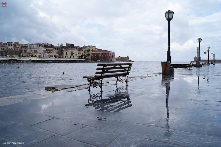
Chania
Chania is a small, picturesque town worth getting to know, where you’ll almost certainly stay longer than you intended, enjoying tasty food, the wonderful harbour, old buildings. great architecture and many more.
It is beautiful - that is to say, much of the Chania you will want to see is clustered close to the harbour - old buildings, museums, churches and crafts shops (some with genuinely interesting and sometimes local, products on offer).
The Venetian, Turkish, traditional and modern architecture coexist in harmony in the city of Chania, creating a unique and attractive scenery for the visitors. Archaeological sites, temples, squares, and unique buildings adorn the attractive city of Chania.
The old city of Chania constitutes a unique historical monument, for which have been made many efforts by the State and the local authorities to preserve and project its historical character.
Despite the intense touristic development of the last few decades, the interventions, the disasters, and the aspect of modern architecture, the old city managed to preserve its historical and its unique architectural character to a great extent.
The city of Chania is built - according to the archaeological research - on the ruins of ancient Kydonia, which according to mythology was founded by king Kydon and was one of the most important cities Of Crete, as Homer mentioned, whereas Kydonians are supposed to be a pre-Hellenic tribe. Chania is a wonderful mixture result of Eastern and Western civilizations.
During the ancient period (3.000-2.800 B.C.) the old harbor was used by the ancient Minoans, as a crossroad of all five Continents. Furthermore, this harbor hosted ancient Kydonia to the late 7th century A.D., one of the most important cities of ancient Crete, while it was conquered many times during the past by Romans, Byzantines, Venetians, Turks, Hebrews, Egyptians, and Arabs, till the end of the 19th century, when it was liberated. Finally, Chania – as well as the whole Crete - was united with independent Greece in 1913 with the significant help of the great Greek politician Eleftherios Venizelos.
Food is offered in great variety and sometimes great similarity - there are many restaurants and also cafes, at which to reflect upon the experiences of places you have just explored together with the enjoyment of some tasty food - we have suggestions for restaurants further on.
The atmosphere has a touch of Florence and Venice (a few years ago when those cities still had some room to walk), combined with the culture and character of Cretan people and traditions.
The Chania harbor is wonderful and at any particular time of day the light produces a different result, creating a "different place".
This is the best chance to see some of the old buildings - of Venetian and Turkish design, that Crete once had across the island - many have since been destroyed by the ravages of war and plunder.
Chania is surrounded by numerous rich options for sightseeing, exploration, and discovery. Mountain villages provide a view into the "inner Crete".
A small harbour may have existed in the past at the base of Kastelli hill but the harbour of Chania as we know it was built by the Venetians over a period of 300 years, starting in 1320. It has two distinct basins: the West basin was mainly used for unloading goods that were stored in warehouses. The eastern basin was used to build and repair ships and was effectively the docklands. It was lined up by arsenals on one side and protected from storms by a long mole leading to the lighthouse.
The 'Arsenali' buildings were dry docks / shipbuilding / ship repair yards built along the eastern harbour between 1467 and 1599. There were 17 of them in a terrace and three more separate ones (the Docks of Moro, built in 1607) towards the eastern end of the harbour. The Arsenali were 50m long and 9m wide rectangular vaulted structures open at the sea side where a ship could be pulled out of the water and dragged into them in order to be worked on. Nine of them were demolished during the Turkish occupation when the docks were converted into military stores.
The Grand Arsenal was originally the end unit of the terrace of 17 vaulted buildings. It was built last, with thicker walls. During Turkish occupation the vault was replaced with a second floor. Later it became a Christian school, then a hospital. It also served as Chania city hall until 1941 when it was partly destroyed by a bombardment. It was extensively restored in 1997 and transformed into an impressive building that hosts various exhibitions and events. It also hosts the Center of Mediterranean Architecture and important Greek and International events related to architecture.
After the Venetians left Crete the harbour fell into disrepair. Because it is quite shallow and tended to silt up, most of the ship traffic moved to the well-protected waters of Souda Bay as well as to the deeper harbour of Heraklion.
What you will find on the harbour front
Because Chania was quite poor and derelict in the 1960s there was very little interest in developing the area to tourism, leaving the harbour and its jumble of Venetian (and a few Turkish) buildings essentially untouched. In 1965 the part of Chania that is enclosed within the fortification walls was declared a protected historical monument. This controlled any developments and means that it now remains the most beautiful Venetian harbour in the Mediterranean.
In the summer there will also be a few excursion boats anchored in the basin.
Another thing that makes the Venetian Harbor in Chania so much fun is that there are cafes, bars, and restaurants that are located right along the pathway, especially at the beginning. These places are throbbing with visitors all day long. During the day, you’ll find people leisurely eating a meal or sipping their drinks while enjoying the view. In the evening, you can either enjoy some of the nightlife or enjoy your dinner in one of the quieter restaurants.
399 Einheimische empfehlen
Old Venetian Harbor
8 Agiou Markou
A small harbour may have existed in the past at the base of Kastelli hill but the harbour of Chania as we know it was built by the Venetians over a period of 300 years, starting in 1320. It has two distinct basins: the West basin was mainly used for unloading goods that were stored in warehouses. The eastern basin was used to build and repair ships and was effectively the docklands. It was lined up by arsenals on one side and protected from storms by a long mole leading to the lighthouse.
The 'Arsenali' buildings were dry docks / shipbuilding / ship repair yards built along the eastern harbour between 1467 and 1599. There were 17 of them in a terrace and three more separate ones (the Docks of Moro, built in 1607) towards the eastern end of the harbour. The Arsenali were 50m long and 9m wide rectangular vaulted structures open at the sea side where a ship could be pulled out of the water and dragged into them in order to be worked on. Nine of them were demolished during the Turkish occupation when the docks were converted into military stores.
The Grand Arsenal was originally the end unit of the terrace of 17 vaulted buildings. It was built last, with thicker walls. During Turkish occupation the vault was replaced with a second floor. Later it became a Christian school, then a hospital. It also served as Chania city hall until 1941 when it was partly destroyed by a bombardment. It was extensively restored in 1997 and transformed into an impressive building that hosts various exhibitions and events. It also hosts the Center of Mediterranean Architecture and important Greek and International events related to architecture.
After the Venetians left Crete the harbour fell into disrepair. Because it is quite shallow and tended to silt up, most of the ship traffic moved to the well-protected waters of Souda Bay as well as to the deeper harbour of Heraklion.
What you will find on the harbour front
Because Chania was quite poor and derelict in the 1960s there was very little interest in developing the area to tourism, leaving the harbour and its jumble of Venetian (and a few Turkish) buildings essentially untouched. In 1965 the part of Chania that is enclosed within the fortification walls was declared a protected historical monument. This controlled any developments and means that it now remains the most beautiful Venetian harbour in the Mediterranean.
In the summer there will also be a few excursion boats anchored in the basin.
Another thing that makes the Venetian Harbor in Chania so much fun is that there are cafes, bars, and restaurants that are located right along the pathway, especially at the beginning. These places are throbbing with visitors all day long. During the day, you’ll find people leisurely eating a meal or sipping their drinks while enjoying the view. In the evening, you can either enjoy some of the nightlife or enjoy your dinner in one of the quieter restaurants.
The naval museum of Chania was created in 1973 and is housed next to the Firkas fortress at the western end of the Venetian harbour.
The museum collection includes models of ships, nautical instruments, paintings, historical photographs and war relics. The material is classified chronologically, starting from the Bronze Age up to our times.
The exhibits include models of ancient ships and an impressive model of the fortified town and port under Venetian rule. A section of the museum is dedicated to the German invasion of Crete.
A more recent section of the museum is located at the eastern end of the harbour (at the Moro Docks) and houses the replica of a Minoan ship.
The museum also has a very informative web site:
http://mar-mus-crete.gr/
Dates Everyday Sunday
01/05 - 31/10 09:00 - 17:00 Closed
01/11 - 30/04 09:00 - 15:40 Closed
The Museum is closed on Public Holidays
Tickets
Regular: 3,00 €
Reduced: 2,50 €
Children, Student: 2,00 €
Permanent Exhibition of Ancient and Traditional Shipbuilding
Operating Hours
Dates Everyday Sunday
01/05 - 31/10 09:00 - 17:00 Closed
01/11 - 30/04 Closed
The Exhibition is closed on Public Holidays
Tickets
Regular: 2,00 €
Children, Student: 1,00 €
Minoan Lines Bonus Club members: 10% discount on the shop. The offer is valid only for members with card.
Minoan Lines Bonus Club Members: Reduced ticket of 2.5€ (regular price 3 euros) and 10% discount on the shop. The offer is valid only for members with card.
Free Addmision
Members of ICOM / ICMM
People with disabilities
Children up to 6 years old
Guides
Journalists
214 Einheimische empfehlen
Maritime Museum of Crete
14-16 DefkalionosThe naval museum of Chania was created in 1973 and is housed next to the Firkas fortress at the western end of the Venetian harbour.
The museum collection includes models of ships, nautical instruments, paintings, historical photographs and war relics. The material is classified chronologically, starting from the Bronze Age up to our times.
The exhibits include models of ancient ships and an impressive model of the fortified town and port under Venetian rule. A section of the museum is dedicated to the German invasion of Crete.
A more recent section of the museum is located at the eastern end of the harbour (at the Moro Docks) and houses the replica of a Minoan ship.
The museum also has a very informative web site:
http://mar-mus-crete.gr/
Dates Everyday Sunday
01/05 - 31/10 09:00 - 17:00 Closed
01/11 - 30/04 09:00 - 15:40 Closed
The Museum is closed on Public Holidays
Tickets
Regular: 3,00 €
Reduced: 2,50 €
Children, Student: 2,00 €
Permanent Exhibition of Ancient and Traditional Shipbuilding
Operating Hours
Dates Everyday Sunday
01/05 - 31/10 09:00 - 17:00 Closed
01/11 - 30/04 Closed
The Exhibition is closed on Public Holidays
Tickets
Regular: 2,00 €
Children, Student: 1,00 €
Minoan Lines Bonus Club members: 10% discount on the shop. The offer is valid only for members with card.
Minoan Lines Bonus Club Members: Reduced ticket of 2.5€ (regular price 3 euros) and 10% discount on the shop. The offer is valid only for members with card.
Free Addmision
Members of ICOM / ICMM
People with disabilities
Children up to 6 years old
Guides
Journalists
In the heart of the Old Town of Chania, you can find Etz Hayyim Synagogue, the only remaining synagogue in Crete. It signifies the many centuries that the Jewish community in Chania city played an important role in the social and commercial life of the city.
When you enter the shady courtyard of the synagogue, you may find its friendly administrator, the historian, Anja Zuckmantel sitting here at a round table. She and her colleagues will be happy to give you a tour of the Synagogue and tell you about the history of the place.
Etz Hayyim stands in the same place it’s been since the Medieval (Venetian) period, crammed into the city’s old town, a walled maze of alleys fanning out from a pretty harbour with a lighthouse. The Ovraiki’s Jewish community stretched many centuries, surviving all kinds of invaders: Byzantines, Venetians, Ottomans. Today, however, there are barely more than a dozen Jews left in Crete (and most of them from abroad), and much of the quarter is home mostly to Starbucks and shops selling “I Love Crete” T-shirts.The synagogue is active and holds weekly Friday Kabbalat Shabbat services and Shabbat Kiddush; most other holidays are also celebrated. Events at Etz Hayyim Synagogue are organized according to the Jewish liturgical year, but also include other cultural programs like concerts and lectures. (a calendar of events is available at: http://www.etz-hayyim-hania.org/newsandevents/ and on the synagogue’s Facebook page) The synagogue is not just a house of prayer open to all Jews, but to everyone (including non-Jews) who shares our values within the tradition of Abraham. Consequently, services are determined to a great degree by specific Jewish denominational needs. There are daily prayer books (siddurim) according to the Sephardic and Mizrahi traditions. For the greater festivals, there are also festival prayer books (mahzorim), as well as talleths and tephillin that are either Sephardic or Ashkenazic. These are available on request to all visitors. Equally, there are also prayer booklets that are based on Conservative, Reform and even Reconstructionist texts that permit active participation for most Jews and even non-Jews.
website: http://www.etz-hayyim-hania.org/
26 Einheimische empfehlen
Etz Hayyim Synagogue
Parodos KondilakiIn the heart of the Old Town of Chania, you can find Etz Hayyim Synagogue, the only remaining synagogue in Crete. It signifies the many centuries that the Jewish community in Chania city played an important role in the social and commercial life of the city.
When you enter the shady courtyard of the synagogue, you may find its friendly administrator, the historian, Anja Zuckmantel sitting here at a round table. She and her colleagues will be happy to give you a tour of the Synagogue and tell you about the history of the place.
Etz Hayyim stands in the same place it’s been since the Medieval (Venetian) period, crammed into the city’s old town, a walled maze of alleys fanning out from a pretty harbour with a lighthouse. The Ovraiki’s Jewish community stretched many centuries, surviving all kinds of invaders: Byzantines, Venetians, Ottomans. Today, however, there are barely more than a dozen Jews left in Crete (and most of them from abroad), and much of the quarter is home mostly to Starbucks and shops selling “I Love Crete” T-shirts.The synagogue is active and holds weekly Friday Kabbalat Shabbat services and Shabbat Kiddush; most other holidays are also celebrated. Events at Etz Hayyim Synagogue are organized according to the Jewish liturgical year, but also include other cultural programs like concerts and lectures. (a calendar of events is available at: http://www.etz-hayyim-hania.org/newsandevents/ and on the synagogue’s Facebook page) The synagogue is not just a house of prayer open to all Jews, but to everyone (including non-Jews) who shares our values within the tradition of Abraham. Consequently, services are determined to a great degree by specific Jewish denominational needs. There are daily prayer books (siddurim) according to the Sephardic and Mizrahi traditions. For the greater festivals, there are also festival prayer books (mahzorim), as well as talleths and tephillin that are either Sephardic or Ashkenazic. These are available on request to all visitors. Equally, there are also prayer booklets that are based on Conservative, Reform and even Reconstructionist texts that permit active participation for most Jews and even non-Jews.
website: http://www.etz-hayyim-hania.org/
The Roman Catholic Church in Chania (1842) meets in the town centre at Halidon Street 46, the road that leads from 1866 Square down to the Venetian harbour. It is dedicated to the Virgin Mary and was inaugurated on April 25, 1879. It is in continuous operation until today and is the cathedral of the Catholic Diocese of Crete, which is also the parish church for the Catholic parish of Chania.
The Capuchin monks arrived in Chania on the orders of Pope Paul V in 1566, led by Father Ignatius IV Aritos, and founded their first monastery in Crete, right where it is today. In a short time, a hospital was opened in the building next to the church, which they named "College". The building of the Monastery of the Capuchin Monks was built in its current form in 1842 and expanded with the addition of an extension in 1860. It was last restored in 1990-1991.
The church serves an international congregation and services are conducted in several languages, including English and Mass booklets are available in a variety of languages including English. All nationalities are made to feel welcome.
https://sites.google.com/site/catholicchania/catholic-church-chania/where-we-are
Capuchin Monastery
Chalidon 46
73100 Chania, Crete, Greece
Telephone: +30 28210 93443
E-mail: vigeher@gmail.com
10 Einheimische empfehlen
Catholic Church
46 ChalidonThe Roman Catholic Church in Chania (1842) meets in the town centre at Halidon Street 46, the road that leads from 1866 Square down to the Venetian harbour. It is dedicated to the Virgin Mary and was inaugurated on April 25, 1879. It is in continuous operation until today and is the cathedral of the Catholic Diocese of Crete, which is also the parish church for the Catholic parish of Chania.
The Capuchin monks arrived in Chania on the orders of Pope Paul V in 1566, led by Father Ignatius IV Aritos, and founded their first monastery in Crete, right where it is today. In a short time, a hospital was opened in the building next to the church, which they named "College". The building of the Monastery of the Capuchin Monks was built in its current form in 1842 and expanded with the addition of an extension in 1860. It was last restored in 1990-1991.
The church serves an international congregation and services are conducted in several languages, including English and Mass booklets are available in a variety of languages including English. All nationalities are made to feel welcome.
https://sites.google.com/site/catholicchania/catholic-church-chania/where-we-are
Capuchin Monastery
Chalidon 46
73100 Chania, Crete, Greece
Telephone: +30 28210 93443
E-mail: vigeher@gmail.com
The Küçük Hasan Pasha Mosque or Gialisi Tzami (mosque of the sea) is actually the only preserved mosque of the city of Chania. It was built on the site of a preexisting Christian temple after the conquest of Chania by the Ottomans in 1645, honoring Küçük Hasan Pasha.
The mosque bears a large semispherical dome supported by stone arches. The north and west sides house a gallery that is topped by six small domes. This gallery was initially open, as used in the mosques, but in the late 19th century it was closed by arched openings.
The mosque was a project of the same Armenian architect that built the mosque of Spaniakos, near Paleochora. The mosque was surrounded by a nice yard with tall palm trees, which hosted the graves of the Ottoman rulers. It ceased its operation in 1923 and its minaret was demolished in 1939.
During the 2nd World War it housed the Archaeological Museum of Chania. Afterwards it was used as a storehouse, folklore museum, tourist information point and exhibition venue.
https://www.google.com/maps/place/%CF%80%CF%81%CF%8E%CE%B7%CE%BD+%CE%A4%CE%B6%CE%B1%CE%BC%CE%AF+%CE%9A%CE%B9%CE%BF%CF%85%CF%84%CF%83%CE%BF%CF%8D%CE%BA+%CE%A7%CE%B1%CF%83%CE%AC%CE%BD/@35.5173841,24.0178426,15z/data=!4m5!3m4!1s0x0:0xddc81835db9ba8bc!8m2!3d35.5173841!4d24.0178426
46 Einheimische empfehlen
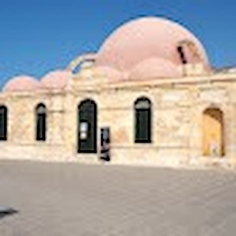
Küçük Hasan Moschee
18 SourmelisThe Küçük Hasan Pasha Mosque or Gialisi Tzami (mosque of the sea) is actually the only preserved mosque of the city of Chania. It was built on the site of a preexisting Christian temple after the conquest of Chania by the Ottomans in 1645, honoring Küçük Hasan Pasha.
The mosque bears a large semispherical dome supported by stone arches. The north and west sides house a gallery that is topped by six small domes. This gallery was initially open, as used in the mosques, but in the late 19th century it was closed by arched openings.
The mosque was a project of the same Armenian architect that built the mosque of Spaniakos, near Paleochora. The mosque was surrounded by a nice yard with tall palm trees, which hosted the graves of the Ottoman rulers. It ceased its operation in 1923 and its minaret was demolished in 1939.
During the 2nd World War it housed the Archaeological Museum of Chania. Afterwards it was used as a storehouse, folklore museum, tourist information point and exhibition venue.
https://www.google.com/maps/place/%CF%80%CF%81%CF%8E%CE%B7%CE%BD+%CE%A4%CE%B6%CE%B1%CE%BC%CE%AF+%CE%9A%CE%B9%CE%BF%CF%85%CF%84%CF%83%CE%BF%CF%8D%CE%BA+%CE%A7%CE%B1%CF%83%CE%AC%CE%BD/@35.5173841,24.0178426,15z/data=!4m5!3m4!1s0x0:0xddc81835db9ba8bc!8m2!3d35.5173841!4d24.0178426
The fortress Revellino del Porto on the northwest side of the old harbor of Chania was constructed by the Venetians as a suppressor against enemy threats and possible invasions. Its construction began in 1610 and was completed a few years before the fall of the city by the Turkish invasion, in 1645.
The interior was organized to barracks and ammunition storage areas. It was also the headquarters of the Commander in Chief of the city’s army. Near the center of the courtyard, there is a large domed water tank that gathered rain water from the roofs. On the northern side of the wall, there are six arched openings that included cannons for the protection of the entrance of the harbor.
During the Turkish period, Revellino was used as barracks (Firka = barrack), for that reason the name Firka is still used today. The arched openings were used as prison cells, from the Turkish period to the civil war. On the corner watch tower of the Fortress, on December 1st, 1913, the Greek flag of the Unification of Crete was raised during an official ceremony. Today, the Maritime Museum of Crete, is housed at the entrance of the Fortress.
Municipal Unit: Chania
Address: Akti Kountourioti, Venetian Port of Chania.
Working hours: Daily 9:00 – 14:00 (01/11 – 31/03) / Daily 09:00 – 19:00 (01/04 – 31/10)
57 Einheimische empfehlen
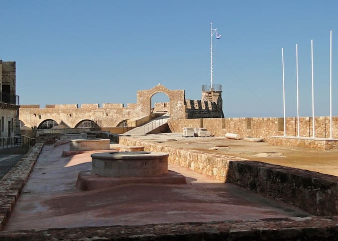
Firka Castle
Akti KountouriotiThe fortress Revellino del Porto on the northwest side of the old harbor of Chania was constructed by the Venetians as a suppressor against enemy threats and possible invasions. Its construction began in 1610 and was completed a few years before the fall of the city by the Turkish invasion, in 1645.
The interior was organized to barracks and ammunition storage areas. It was also the headquarters of the Commander in Chief of the city’s army. Near the center of the courtyard, there is a large domed water tank that gathered rain water from the roofs. On the northern side of the wall, there are six arched openings that included cannons for the protection of the entrance of the harbor.
During the Turkish period, Revellino was used as barracks (Firka = barrack), for that reason the name Firka is still used today. The arched openings were used as prison cells, from the Turkish period to the civil war. On the corner watch tower of the Fortress, on December 1st, 1913, the Greek flag of the Unification of Crete was raised during an official ceremony. Today, the Maritime Museum of Crete, is housed at the entrance of the Fortress.
Municipal Unit: Chania
Address: Akti Kountourioti, Venetian Port of Chania.
Working hours: Daily 9:00 – 14:00 (01/11 – 31/03) / Daily 09:00 – 19:00 (01/04 – 31/10)
The original Venetian lighthouse was built around the late 16th century to protect the harbour. A chain could be connected from the base of the lighthouse to the fortress of Firkas in oder to close the harbour.
During the Turkish occupation the lighthouse fell into disrepair and was eventually rebuilt between 1824 and 1832 in the form of a minaret. The modern lighthouse is often referred to as ' Egyptian' because it was built during a time where Crete was occupied by Egyptian troops who were supporting the weakening Ottoman Empire against the rebellious Cretans.
The base of the lighthouse is still the original Venetian base although the Lion of St. Marc which was carved there has long gone.
The 'Egyptian' lighthouse was leaning badly due to bombings during WWII and earthquakes but it was extensively renovated in 2005 and now looks as good as new.
The lighthouse is located at the end of a long mole that protects the Venetian harbour from the sea. It is well worth walking all the way to the end of it as you get splendid views from the harbour.
Unfortunately the lighthouse itself is closed so you can't go up the tower.
184 Einheimische empfehlen
Leuchtturm
The original Venetian lighthouse was built around the late 16th century to protect the harbour. A chain could be connected from the base of the lighthouse to the fortress of Firkas in oder to close the harbour.
During the Turkish occupation the lighthouse fell into disrepair and was eventually rebuilt between 1824 and 1832 in the form of a minaret. The modern lighthouse is often referred to as ' Egyptian' because it was built during a time where Crete was occupied by Egyptian troops who were supporting the weakening Ottoman Empire against the rebellious Cretans.
The base of the lighthouse is still the original Venetian base although the Lion of St. Marc which was carved there has long gone.
The 'Egyptian' lighthouse was leaning badly due to bombings during WWII and earthquakes but it was extensively renovated in 2005 and now looks as good as new.
The lighthouse is located at the end of a long mole that protects the Venetian harbour from the sea. It is well worth walking all the way to the end of it as you get splendid views from the harbour.
Unfortunately the lighthouse itself is closed so you can't go up the tower.
The Grand Arsenal located in the Venetian harbor of Chania. It is a shipyard since the Venetian era which was used for fleet repair needs.
It seems to be the last which constructed of the shipyards of Chania harbor. Its construction started in 1585 and completed in 1600 by Intendant Alvise Grimani. During the Ottoman period, in 1872 one floor was added to the building. From that time began to serve from time to time, various public functions, such as Christian school, theater, hospital and town hall. In 1941 it was severely damaged by German bombing.
Today, after maintenance of the building and architectural restoration of the interior, serves as the Mediterranean Architecture Centre. Here hosted international and Greek events and exhibitions focusing on architecture.
16 Einheimische empfehlen
KAM Center of Mediterranean Architecture
Πλατεια Γεωργιου ΚατεχακηThe Grand Arsenal located in the Venetian harbor of Chania. It is a shipyard since the Venetian era which was used for fleet repair needs.
It seems to be the last which constructed of the shipyards of Chania harbor. Its construction started in 1585 and completed in 1600 by Intendant Alvise Grimani. During the Ottoman period, in 1872 one floor was added to the building. From that time began to serve from time to time, various public functions, such as Christian school, theater, hospital and town hall. In 1941 it was severely damaged by German bombing.
Today, after maintenance of the building and architectural restoration of the interior, serves as the Mediterranean Architecture Centre. Here hosted international and Greek events and exhibitions focusing on architecture.
Koum Kapi is an especial quarter of Chania city. It is located just to the east of Chania old Venetian Harbor.
Koum Kapi features the only beach inside Chania city, as it is located on a beautiful coastal zone. The name “Koum Kapi” originates from the Turkish word “Kum Kapisi”, which means Gate of Sand. The Gate of Sand, which was originally called “Sabionera” by the Venetians, took its name after a real gate on the old walls of Chania city that led to a beautiful sandy beach.
Koum Kapi, Chania – a place with a multicultural history
In the mid-19th century, Koum Kapi was home to about 2.500 poor people from North Africa (mainly from Benghazi), who had been brought to the place by the Ottomans in order to carry out all the harsh jobs of Chania harbor. They were collectively called “Halikoutes” by the locals.
These people, who were essentially living as slaves, used to live in tents, as most of them where Bedouins, or huts made from tin or other easy to find materials. The sanitary conditions in the area of Koum Kapi were terrible.
This situation lasted until 1913, the year of the reunion of Crete with Greece, when all these poverty stricken people managed to return from Koum Kapi and Chania to North Africa, after the agreements for population exchange between Greece and the former Ottoman empire.
After that, the authorities of Chania took great care to regenerate Koum Kapi, and turn it into a modern European neighborhood, like the rest of Chania city. These efforts started gradually to pay off.
After the great catastrophic wars in Asia Minor, which lead to horrible massacres and the massive dislodgement of millions of Greeks by the Turkish army, many Greek refugees from Asia Minor came to Chania in 1924 and afterwards, and many of them stayed in Koum Kapi. As many of these refugees where traders and generally people of high education, they largely contributed to the improvement of the living conditions in Koum Kapi, which gradually became one of the best neighborhoods in Chania city.
Koum Kapi in today’s Chania
Today, Koum Kapi is one of the best places in Chania to eat, drink, and entertain yourself. There are many quality cafes, bars and taverns in the area, all of them providing excellent view to the sea and the beach.
The view from Koum Kapi is really fantastic: On the left we see the Gate of Sand on the old walls of Chania, where the name of the quarter came from. In front of us, the vast sea and the beach of Koum Kapi make a marvelous spectacle. And on the right, we see the eastern suburbs of Chania city unfolding in the horizon.
Koum Kapi is rightfully one of the prettiest corners of Chania city, with plenty of options to have a good time and admire the breathtaking view. After visiting the Old City of Chania and the Venetian Harbor, don’t forget to also visit Koum Kapi: chances are you will be pleasantly surprised.
8 Einheimische empfehlen
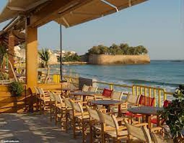
Koum Kapi
Koum Kapi is an especial quarter of Chania city. It is located just to the east of Chania old Venetian Harbor.
Koum Kapi features the only beach inside Chania city, as it is located on a beautiful coastal zone. The name “Koum Kapi” originates from the Turkish word “Kum Kapisi”, which means Gate of Sand. The Gate of Sand, which was originally called “Sabionera” by the Venetians, took its name after a real gate on the old walls of Chania city that led to a beautiful sandy beach.
Koum Kapi, Chania – a place with a multicultural history
In the mid-19th century, Koum Kapi was home to about 2.500 poor people from North Africa (mainly from Benghazi), who had been brought to the place by the Ottomans in order to carry out all the harsh jobs of Chania harbor. They were collectively called “Halikoutes” by the locals.
These people, who were essentially living as slaves, used to live in tents, as most of them where Bedouins, or huts made from tin or other easy to find materials. The sanitary conditions in the area of Koum Kapi were terrible.
This situation lasted until 1913, the year of the reunion of Crete with Greece, when all these poverty stricken people managed to return from Koum Kapi and Chania to North Africa, after the agreements for population exchange between Greece and the former Ottoman empire.
After that, the authorities of Chania took great care to regenerate Koum Kapi, and turn it into a modern European neighborhood, like the rest of Chania city. These efforts started gradually to pay off.
After the great catastrophic wars in Asia Minor, which lead to horrible massacres and the massive dislodgement of millions of Greeks by the Turkish army, many Greek refugees from Asia Minor came to Chania in 1924 and afterwards, and many of them stayed in Koum Kapi. As many of these refugees where traders and generally people of high education, they largely contributed to the improvement of the living conditions in Koum Kapi, which gradually became one of the best neighborhoods in Chania city.
Koum Kapi in today’s Chania
Today, Koum Kapi is one of the best places in Chania to eat, drink, and entertain yourself. There are many quality cafes, bars and taverns in the area, all of them providing excellent view to the sea and the beach.
The view from Koum Kapi is really fantastic: On the left we see the Gate of Sand on the old walls of Chania, where the name of the quarter came from. In front of us, the vast sea and the beach of Koum Kapi make a marvelous spectacle. And on the right, we see the eastern suburbs of Chania city unfolding in the horizon.
Koum Kapi is rightfully one of the prettiest corners of Chania city, with plenty of options to have a good time and admire the breathtaking view. After visiting the Old City of Chania and the Venetian Harbor, don’t forget to also visit Koum Kapi: chances are you will be pleasantly surprised.
'Leather Street' also called 'Leather Lane' or 'Stivanadika' (after 'stivania' which is what the tall Cretan boots are called) is a small street (officially its name is Skrydlof Street, near the Venetian Port, where shoemakers used to have their workshops in Chania. Of course nowadays almost no one makes shoes or boots by hand so the old workshops have been essentially turned into shops selling leather goods that are manufactured elsewhere (some still made in Chania though).
In the tourist season it is a very busy street as all organized day trips to Chania seem to include a walk through it. There is a lot of junk but you can find also good bargains (and good quality) leather goods (purses, bags, sandals) so it is still worth braving the crowds to have a look at it.
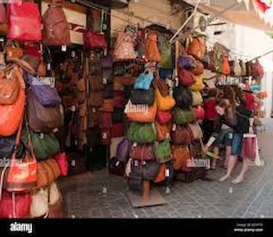
Leather Shop
24 Skridlof'Leather Street' also called 'Leather Lane' or 'Stivanadika' (after 'stivania' which is what the tall Cretan boots are called) is a small street (officially its name is Skrydlof Street, near the Venetian Port, where shoemakers used to have their workshops in Chania. Of course nowadays almost no one makes shoes or boots by hand so the old workshops have been essentially turned into shops selling leather goods that are manufactured elsewhere (some still made in Chania though).
In the tourist season it is a very busy street as all organized day trips to Chania seem to include a walk through it. There is a lot of junk but you can find also good bargains (and good quality) leather goods (purses, bags, sandals) so it is still worth braving the crowds to have a look at it.
Heading towards the Venetian Harbour you will pass Chalidon Street. On Chalidon Street are the Catholic Church and the Orthodox Cathedral Church of Chania.
Halidon Street boasts a plethora of shops for the tourist shopper – there are certainly two or three good jewelers as well as several fashion shops worth seeking out – and, recently opened, a glitzy fur shop complete with shiny sign in Russian script. Otherwise Chalidon and two or three tributary streets are dedicated to the usual choice of leather, ice cream, worry beads, feet-gnawing fish, frozen yoghurt and sandals. A little farther afield, towards the central market, a couple of outlets offer cutting-edge jewelry and handbag design, custom made perfumes, etc.
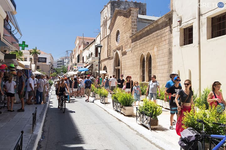
Chalidon
ChalidonHeading towards the Venetian Harbour you will pass Chalidon Street. On Chalidon Street are the Catholic Church and the Orthodox Cathedral Church of Chania.
Halidon Street boasts a plethora of shops for the tourist shopper – there are certainly two or three good jewelers as well as several fashion shops worth seeking out – and, recently opened, a glitzy fur shop complete with shiny sign in Russian script. Otherwise Chalidon and two or three tributary streets are dedicated to the usual choice of leather, ice cream, worry beads, feet-gnawing fish, frozen yoghurt and sandals. A little farther afield, towards the central market, a couple of outlets offer cutting-edge jewelry and handbag design, custom made perfumes, etc.
Near Kastelli and Koum Kapi, north-east of the old town of Chania, is the Splantzia district. Its distinctive feature is its square with the church of Agios Nikolaos (St Nicholas), part of the old Dominican friary, which was converted into the Mosque of Sultan Ibrahim during the Turkish period.
The church of St Nicholas was converted into a barracks for the Turkish Janissaries, but was also their place of daily prayer. The church was renamed “Hügar Tzamissi”, probably a corruption of “Hükümdar Tzamissi”, meaning “Mosque of the Sovereign”. It housed the scimitar of the Turkish dervish who was the first to enter the city, a sacred and miraculous relic to the Turks. The minaret which was added to the church has two distinctive circular balconies.
At the center of the square, there is a huge plane tree and there is a catacomb between the church and the plane tree. During Ottoman rule, under the plane tree, there was an octagonal Arabian kiosk, to which the aristocrats of the Turkish state had the right to sit. Now there is a monument in honor of Greek Christians who were tortured and killed at this point during the Greek Revolution. After excavations that took place, a large tank was found in the catacomb. On the Venetians and the Turks, an underground fountain was constructed and used as ritual space.
Today, on the perimeter of the square, small cafes and taverns are housed, while the huge plane tree offers rich shade and coolness during the summer months. It is now respectively a very popular hangout spot for the local youth and an alternative to the nightlife scene of the Venetian Harbor. While you're there visit The Church of St. Caterina and St. John the Hermit
An unorthodox looking Greek Orthodox chapel built during the Venetian area, hence the architectural influences that underwent many transitional uses until it was restored as a temple of worship.
Nearby is the church of San Rocco, a round Venetian church which is no longer in use. St Rocco protected the inhabitants of Chania from the plague, a sign that the scourge of Europe in the Middle Ages did not leave Chania untouched.
During the Turkish period, the Splantzia was the Turkish quarter, the equivalent of the Christian quarter in Sindrivani Square in the harbour, the center of the social and political life of Chania.
15 Einheimische empfehlen
Splantzia Square
5 Rousou VourdoumpaNear Kastelli and Koum Kapi, north-east of the old town of Chania, is the Splantzia district. Its distinctive feature is its square with the church of Agios Nikolaos (St Nicholas), part of the old Dominican friary, which was converted into the Mosque of Sultan Ibrahim during the Turkish period.
The church of St Nicholas was converted into a barracks for the Turkish Janissaries, but was also their place of daily prayer. The church was renamed “Hügar Tzamissi”, probably a corruption of “Hükümdar Tzamissi”, meaning “Mosque of the Sovereign”. It housed the scimitar of the Turkish dervish who was the first to enter the city, a sacred and miraculous relic to the Turks. The minaret which was added to the church has two distinctive circular balconies.
At the center of the square, there is a huge plane tree and there is a catacomb between the church and the plane tree. During Ottoman rule, under the plane tree, there was an octagonal Arabian kiosk, to which the aristocrats of the Turkish state had the right to sit. Now there is a monument in honor of Greek Christians who were tortured and killed at this point during the Greek Revolution. After excavations that took place, a large tank was found in the catacomb. On the Venetians and the Turks, an underground fountain was constructed and used as ritual space.
Today, on the perimeter of the square, small cafes and taverns are housed, while the huge plane tree offers rich shade and coolness during the summer months. It is now respectively a very popular hangout spot for the local youth and an alternative to the nightlife scene of the Venetian Harbor. While you're there visit The Church of St. Caterina and St. John the Hermit
An unorthodox looking Greek Orthodox chapel built during the Venetian area, hence the architectural influences that underwent many transitional uses until it was restored as a temple of worship.
Nearby is the church of San Rocco, a round Venetian church which is no longer in use. St Rocco protected the inhabitants of Chania from the plague, a sign that the scourge of Europe in the Middle Ages did not leave Chania untouched.
During the Turkish period, the Splantzia was the Turkish quarter, the equivalent of the Christian quarter in Sindrivani Square in the harbour, the center of the social and political life of Chania.
Nea Chora (which means 'new town') was the first modern part of Chania to be built outside the Venetian fortification wall in the early 18th century. In a sense it is the oldest part of the modern town. Nea Chora has a fishing harbour and a good sandy beach which is popular with local people. It is in effect Chania's town beach and it is a nice one.
The small road that runs along the beach is lined with cafés and (mainly fish) restaurants which are worth visiting . It is only 10 minutes on foot (walking along the sea front) from the Venetian harbour and the center of the Old Town.
18 Einheimische empfehlen
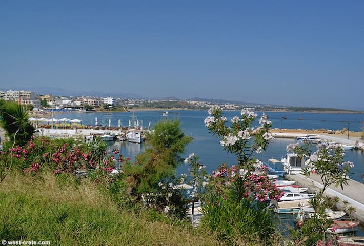
Nea Chora
Nea Chora (which means 'new town') was the first modern part of Chania to be built outside the Venetian fortification wall in the early 18th century. In a sense it is the oldest part of the modern town. Nea Chora has a fishing harbour and a good sandy beach which is popular with local people. It is in effect Chania's town beach and it is a nice one.
The small road that runs along the beach is lined with cafés and (mainly fish) restaurants which are worth visiting . It is only 10 minutes on foot (walking along the sea front) from the Venetian harbour and the center of the Old Town.
The Botanical Park of Crete in Chania is as a small continent, the flora and fauna of this lovely island is abundant and fascinates and inspires all the people who visit it.
Self-Guided
1-4 Hours
Wildlife & Nature
Agrotourism/Ethnography
Quite impossible to see all of them in a week or a few days during your holidays.
But don't worry, Botanical Park a nearly 20 hectares of land are waiting to welcome you, only 18 Km outside the town of Chania, on the feet of the White Mountains, full of fruit trees from all over the world, herbs, medicinal and ornamental plants in a park different from others, where the land’s formation and the region’s microclimate make it a paradise for hundreds of plants and animals!
In the midst of this colorful and vivid landscape stands a burnt centennial olive tree, a memorial, and a reference to the dismal fires of 2003 (thus came to the idea as well), the park’s history and origin.
The newest and one of the most interesting sites of the Prefecture of Chania is ideal for visitors of all ages, combining enjoyments that only Crete can offer!
Shortly after you pass Fournes village and before the historical Lakkoi-Skordalou, a sign will direct you towards the Botanical Park, to an unprecedented tour of the region’s magical nature and the creative imagination of the four brothers who dreamt of and realized this unique heaven on earth!
When you first see the park and its facilities, it is impossible to imagine that this is the same expanse of the 15-20 hectares which burnt to the ground in the fires of 2003, today literary reborn from its ashes.
In the place of the grey landscape stands a walking, educational, and entertainment park-unique in its kind in Crete – waiting for young and old, locals and foreigners, to get acquainted with the more than 150 species of fruit trees together with the dozens of herbs, medicinal and ornamental plants it hosts while enjoying their walk through a lush natural environment.
The secret of enjoying your visit to the maximum is to wander through the paths of the Botanical Park slowly and leisurely, making many stops for rest in the various suitable rest points available. Thus you shall have the opportunity to truly appreciate the beauty which you will encounter.
No matter how you see your visit here, whether as a scenic trek, or an interesting tour of nature’s paths, the Botanical Park is the ideal alternative proposal for a day’s escape from the city’s noise and the fashionable beaches.
The dramatic scenery here is composed of rare samples of the local flora and fauna, as well as tropical and subtropical species from all over the world, with new samples added daily, changing the look of the Botanical Park and providing visitors with a motive to enjoy it over and over again!
This adventure in nature which lasts one to two hours follows paths of unique natural beauty and provides visitors with the opportunity to get acquainted with the numerous different plants and trees that grow on the two hundred square kilometers of the well-designed planted hillside.
The appropriate signposting of the paths lead the visitor to various sections of the Botanical Park (tropical trees, fruit-bearing trees, citrus trees, herbs, and vineyards).
The lush landscape is completed by the lake in the lower part of the part, offering accommodation and protection to ducks, geese, and other water birds (and rare species), even to hawks that fly in the area. The park also has an open-air, stone atmospheric amphitheater suitable for small (capacity for approximately 250 persons) events.
Depending on the time of the year, you will have the opportunity to enjoy flowers, plants, and trees through all phases of their life-cycle, parallel to the various species of wild flora and fauna which they attract each season. Any time of the year you visit the Botanical Park, you will be impressed by the colors, fragrances, and variety of species.
During the summer months, the best time to schedule your visit is early in the morning, avoiding the strong heat, and having the opportunity to complete your experience with an excellent meal in the park’s restaurant. Its totally local, organic and seasonal philosophy will be unforgettable.
Prices
General Admission: 6 Euros
Ages 6 to 12: 4 Euros
Ages 6 and under are FREE with parents!
Operating Hours
MARCH 1st TO MIDDLE OF NOVEMBER
MON - SUN
09:00 - 1 hour before sunset
Dinner served until 6pm
site: https://www.botanical-park.com/
219 Einheimische empfehlen
Botanischer Park und Gärten von Kreta
Eparchiaki Odos Chanion-Omalou The Botanical Park of Crete in Chania is as a small continent, the flora and fauna of this lovely island is abundant and fascinates and inspires all the people who visit it.
Self-Guided
1-4 Hours
Wildlife & Nature
Agrotourism/Ethnography
Quite impossible to see all of them in a week or a few days during your holidays.
But don't worry, Botanical Park a nearly 20 hectares of land are waiting to welcome you, only 18 Km outside the town of Chania, on the feet of the White Mountains, full of fruit trees from all over the world, herbs, medicinal and ornamental plants in a park different from others, where the land’s formation and the region’s microclimate make it a paradise for hundreds of plants and animals!
In the midst of this colorful and vivid landscape stands a burnt centennial olive tree, a memorial, and a reference to the dismal fires of 2003 (thus came to the idea as well), the park’s history and origin.
The newest and one of the most interesting sites of the Prefecture of Chania is ideal for visitors of all ages, combining enjoyments that only Crete can offer!
Shortly after you pass Fournes village and before the historical Lakkoi-Skordalou, a sign will direct you towards the Botanical Park, to an unprecedented tour of the region’s magical nature and the creative imagination of the four brothers who dreamt of and realized this unique heaven on earth!
When you first see the park and its facilities, it is impossible to imagine that this is the same expanse of the 15-20 hectares which burnt to the ground in the fires of 2003, today literary reborn from its ashes.
In the place of the grey landscape stands a walking, educational, and entertainment park-unique in its kind in Crete – waiting for young and old, locals and foreigners, to get acquainted with the more than 150 species of fruit trees together with the dozens of herbs, medicinal and ornamental plants it hosts while enjoying their walk through a lush natural environment.
The secret of enjoying your visit to the maximum is to wander through the paths of the Botanical Park slowly and leisurely, making many stops for rest in the various suitable rest points available. Thus you shall have the opportunity to truly appreciate the beauty which you will encounter.
No matter how you see your visit here, whether as a scenic trek, or an interesting tour of nature’s paths, the Botanical Park is the ideal alternative proposal for a day’s escape from the city’s noise and the fashionable beaches.
The dramatic scenery here is composed of rare samples of the local flora and fauna, as well as tropical and subtropical species from all over the world, with new samples added daily, changing the look of the Botanical Park and providing visitors with a motive to enjoy it over and over again!
This adventure in nature which lasts one to two hours follows paths of unique natural beauty and provides visitors with the opportunity to get acquainted with the numerous different plants and trees that grow on the two hundred square kilometers of the well-designed planted hillside.
The appropriate signposting of the paths lead the visitor to various sections of the Botanical Park (tropical trees, fruit-bearing trees, citrus trees, herbs, and vineyards).
The lush landscape is completed by the lake in the lower part of the part, offering accommodation and protection to ducks, geese, and other water birds (and rare species), even to hawks that fly in the area. The park also has an open-air, stone atmospheric amphitheater suitable for small (capacity for approximately 250 persons) events.
Depending on the time of the year, you will have the opportunity to enjoy flowers, plants, and trees through all phases of their life-cycle, parallel to the various species of wild flora and fauna which they attract each season. Any time of the year you visit the Botanical Park, you will be impressed by the colors, fragrances, and variety of species.
During the summer months, the best time to schedule your visit is early in the morning, avoiding the strong heat, and having the opportunity to complete your experience with an excellent meal in the park’s restaurant. Its totally local, organic and seasonal philosophy will be unforgettable.
Prices
General Admission: 6 Euros
Ages 6 to 12: 4 Euros
Ages 6 and under are FREE with parents!
Operating Hours
MARCH 1st TO MIDDLE OF NOVEMBER
MON - SUN
09:00 - 1 hour before sunset
Dinner served until 6pm
site: https://www.botanical-park.com/
Located in the area of Halepa, Chania’s new museum covers an area of 6,000sqm and has replaced the previous archaeological museum that operated in the area of Agios Fragiskos until September 2020.
Among the museum’s 3,500 artifacts some 1,000 will be exhibited for the first time. The museum’s permanent exhibition displays Chania’s evolution through time, starting from its prehistoric period and will focus on the area’s society, administration, religion, commerce and everyday life. Digital applications are also available to facilitate visitors to comprehend the exhibitions.
In addition, the new museum features large spaces suitable to host periodical exhibitions, educational programs and events.
https://www.amch.gr/
Administrative Information
Skra 15, Chania, Τ.Κ. 73133, Chania (Prefecture of Hania)
Telephone: 28210 - 23315
Email: efacha@culture.gr
Tickets
Full: €6, Reduced: €3
Free admission days
6 March (in memory of Melina Mercouri)
18 April (International Monuments Day)
18 May (International Museums Day)
The last weekend of September annually (European Heritage Days)
28 October
Every first Sunday from November 1st to March 31st
41 Einheimische empfehlen
Neues Archäologisches Museum von Chania
15 SkraLocated in the area of Halepa, Chania’s new museum covers an area of 6,000sqm and has replaced the previous archaeological museum that operated in the area of Agios Fragiskos until September 2020.
Among the museum’s 3,500 artifacts some 1,000 will be exhibited for the first time. The museum’s permanent exhibition displays Chania’s evolution through time, starting from its prehistoric period and will focus on the area’s society, administration, religion, commerce and everyday life. Digital applications are also available to facilitate visitors to comprehend the exhibitions.
In addition, the new museum features large spaces suitable to host periodical exhibitions, educational programs and events.
https://www.amch.gr/
Administrative Information
Skra 15, Chania, Τ.Κ. 73133, Chania (Prefecture of Hania)
Telephone: 28210 - 23315
Email: efacha@culture.gr
Tickets
Full: €6, Reduced: €3
Free admission days
6 March (in memory of Melina Mercouri)
18 April (International Monuments Day)
18 May (International Museums Day)
The last weekend of September annually (European Heritage Days)
28 October
Every first Sunday from November 1st to March 31st
The rich archaeological material yielded by excavations conducted over many years by the 13th Ephorate of Byzantine Antiquities in the county of Chania, and also by retrieval of material and donations, forms a Collection that records, with great clarity, the history of the westernmost county in Crete from the Early Christian times to the period of Turkish rule. Representative examples of this Collection are displayed in the church of San Salvatore. Built on the west side of the fortress of Chania, next to the bastion of the same name, the church was the katholikon of the Franciscan monastery of San Salvatore. The cloister (chiostro) that housed the cells of the monks is still preserved on the south side of the monument. The extensive restoration of the church made it possible to identify more clearly the various building phases of the monument, unify the space, and display its austere, uncluttered architectural features to good effect. The original church, which probably dates from the 15th century, was the small domed section on the east side. In the 16th century, this was extended to the west, following the same type of a vaulted hall with strainer arches. At the end of the Venetian period (middle of the 17th century), the church was extended to the north by the addition of two rectangular rooms with an entrance on the west side. These rooms, in which a limited use of Gothic motives can be observed, were roofed by cross-vaults and communicate with the nave by means of large archways. Under the Turkish domination, the church was converted into a mosque, the original church being detached and a sanctuary apse (mihrab) created at the south-west corner of the south aisle.
The aim behind the presentation of this material is to sketch the historical and artistic profile of the county of Chania during Byzantine and post-Byzantine times. The exhibits have been divided into groups based on the kind of object: mosaics, funerary inscriptions, wall-paintings, icons, architectural sculptures, ceramics and items of minor arts, and coins. The objects in each unit are presented in chronological order. Maps and explanatory panels inform visitors about the provenance of the items on display and the historical background of their period.
Some of the most important exhibits of the Collection are:
• Part of a mosaic floor of an Early Christian basilica with a depiction of a deer and a vine. 6th century.
• Two-zone column-capital decorated with acanthus leaves and birds. 6th century.
• Gold pendant with a bead of glass-paste. 6th-7th century.
• Bronze lamp with handle decoratd with a cross and a winding tendril. 6th-7th century.
• Jugs. 6th-7th century.
• Two-sided closure panel with representations of animals and plants and crosses on the narrow sides. 8th-9th century.
• Part of a wall-painting with a depiction of Saints Merkourios and Mamas. 11th century.
• Pair of bronze earrings from a female tomb. 11th-12th century.
• Grosso of Doge Pietro Gradenigo (1289-1311).
• Sherd of a glazed vase with a depiction of a human figure. 15th - 1st half of 17th century.
• Apotropaic horned mask. 16th-17th century.
• Votive inscription with coats-of-arms of Venetian families from the town of Chania (1623). The inscription read as follows: "...the governor Jacopo Palma, and all his infantry and cavalry forces had this monument erected in the year of Christ 1623, in honour of this great man, who courageously resisted the enemy in battle, the founder of peace, the just ruler".
• Icon with a depiction of Saint George on horseback slaying the dragon. By the painter Emmanuel Tzanes (1660-1680).
• Bronze lamps. 17th century.
Address: 82, Theotokopoulou Street, San Salvatore Venetian Church, 73100 CHANIA , CRETE , GREECE
Tel.: +30 28210 96046
Opening hours:
01Jun - 31Oct Tue-Sun, 0900-1600
01Nov - 31May Tue-Sun, 0800-1500
Full: €3, Reduced: €2
Free admission days
6 March (in memory of Melina Mercouri)
18 April (International Monuments Day)
18 May (International Museums Day)
The last weekend of September annually (European Heritage Days)
National Holidays
Every first Sunday from November 1st to March 31st
http://odysseus.culture.gr/h/1/eh155.jsp?obj_id=3334
18 Einheimische empfehlen
Byzantine/Post-Byzantine Collection
78 Theotokopoulou The rich archaeological material yielded by excavations conducted over many years by the 13th Ephorate of Byzantine Antiquities in the county of Chania, and also by retrieval of material and donations, forms a Collection that records, with great clarity, the history of the westernmost county in Crete from the Early Christian times to the period of Turkish rule. Representative examples of this Collection are displayed in the church of San Salvatore. Built on the west side of the fortress of Chania, next to the bastion of the same name, the church was the katholikon of the Franciscan monastery of San Salvatore. The cloister (chiostro) that housed the cells of the monks is still preserved on the south side of the monument. The extensive restoration of the church made it possible to identify more clearly the various building phases of the monument, unify the space, and display its austere, uncluttered architectural features to good effect. The original church, which probably dates from the 15th century, was the small domed section on the east side. In the 16th century, this was extended to the west, following the same type of a vaulted hall with strainer arches. At the end of the Venetian period (middle of the 17th century), the church was extended to the north by the addition of two rectangular rooms with an entrance on the west side. These rooms, in which a limited use of Gothic motives can be observed, were roofed by cross-vaults and communicate with the nave by means of large archways. Under the Turkish domination, the church was converted into a mosque, the original church being detached and a sanctuary apse (mihrab) created at the south-west corner of the south aisle.
The aim behind the presentation of this material is to sketch the historical and artistic profile of the county of Chania during Byzantine and post-Byzantine times. The exhibits have been divided into groups based on the kind of object: mosaics, funerary inscriptions, wall-paintings, icons, architectural sculptures, ceramics and items of minor arts, and coins. The objects in each unit are presented in chronological order. Maps and explanatory panels inform visitors about the provenance of the items on display and the historical background of their period.
Some of the most important exhibits of the Collection are:
• Part of a mosaic floor of an Early Christian basilica with a depiction of a deer and a vine. 6th century.
• Two-zone column-capital decorated with acanthus leaves and birds. 6th century.
• Gold pendant with a bead of glass-paste. 6th-7th century.
• Bronze lamp with handle decoratd with a cross and a winding tendril. 6th-7th century.
• Jugs. 6th-7th century.
• Two-sided closure panel with representations of animals and plants and crosses on the narrow sides. 8th-9th century.
• Part of a wall-painting with a depiction of Saints Merkourios and Mamas. 11th century.
• Pair of bronze earrings from a female tomb. 11th-12th century.
• Grosso of Doge Pietro Gradenigo (1289-1311).
• Sherd of a glazed vase with a depiction of a human figure. 15th - 1st half of 17th century.
• Apotropaic horned mask. 16th-17th century.
• Votive inscription with coats-of-arms of Venetian families from the town of Chania (1623). The inscription read as follows: "...the governor Jacopo Palma, and all his infantry and cavalry forces had this monument erected in the year of Christ 1623, in honour of this great man, who courageously resisted the enemy in battle, the founder of peace, the just ruler".
• Icon with a depiction of Saint George on horseback slaying the dragon. By the painter Emmanuel Tzanes (1660-1680).
• Bronze lamps. 17th century.
Address: 82, Theotokopoulou Street, San Salvatore Venetian Church, 73100 CHANIA , CRETE , GREECE
Tel.: +30 28210 96046
Opening hours:
01Jun - 31Oct Tue-Sun, 0900-1600
01Nov - 31May Tue-Sun, 0800-1500
Full: €3, Reduced: €2
Free admission days
6 March (in memory of Melina Mercouri)
18 April (International Monuments Day)
18 May (International Museums Day)
The last weekend of September annually (European Heritage Days)
National Holidays
Every first Sunday from November 1st to March 31st
http://odysseus.culture.gr/h/1/eh155.jsp?obj_id=3334
Municipal Art Gallery Of Chania Crete
Chania Prefecture – Chania
Details / Information Overview:
In the first period of its operation, the gallery presented just a part of the collection of art that the Municipality of Chania manages to acquire during the years. Later, the general idea was to begin operating as a Municipal Art Gallery.
At the same time, became an effort to approach the historical character of the existing collection, to discover the course of the art of the local artists, in a historical aspect.
However, the collection of Municipality Chania numbers today many artists works, that for maintenance purposes, restoration, etc, was not possible to be exposed.
The next move for the Municipality of Chania is to designate the gallery as an institute of protection and rescue of culture with a wider possible significance, than just a museum of art. A center of art, where several fields of art, science, and speech can exist together, seeking each other subscription, in order to become feasible the realization of objectives and visions that each one of these fields of Human’s spirit expression can offer to the society.
Address:98-102, Chalidon Str. GR-73100
Operating Period:
JAN-DEC
Operating Days & Hours Operating Days & Hours:
MON-SAT: 10:00-14:00 & 18:00-21:00
SUN: Closed
Admission Fee:
• General admission: Full: €2, Reduced: €1
https://pinakothiki-chania.gr/en/
57 Einheimische empfehlen
Municipal Art Gallery
98 ChalidonMunicipal Art Gallery Of Chania Crete
Chania Prefecture – Chania
Details / Information Overview:
In the first period of its operation, the gallery presented just a part of the collection of art that the Municipality of Chania manages to acquire during the years. Later, the general idea was to begin operating as a Municipal Art Gallery.
At the same time, became an effort to approach the historical character of the existing collection, to discover the course of the art of the local artists, in a historical aspect.
However, the collection of Municipality Chania numbers today many artists works, that for maintenance purposes, restoration, etc, was not possible to be exposed.
The next move for the Municipality of Chania is to designate the gallery as an institute of protection and rescue of culture with a wider possible significance, than just a museum of art. A center of art, where several fields of art, science, and speech can exist together, seeking each other subscription, in order to become feasible the realization of objectives and visions that each one of these fields of Human’s spirit expression can offer to the society.
Address:98-102, Chalidon Str. GR-73100
Operating Period:
JAN-DEC
Operating Days & Hours Operating Days & Hours:
MON-SAT: 10:00-14:00 & 18:00-21:00
SUN: Closed
Admission Fee:
• General admission: Full: €2, Reduced: €1
https://pinakothiki-chania.gr/en/
GETTING TO KNOW THE TRADITIONAL CRETAN KNIFE MAKERS OF CHANIA CITY
Armenis Shop
https://oarmenis.gr/en/
We have all heard a story about the famous Cretan knife, a tradition that continues today by some experienced craftsmen in the city of Chania.
You will find a wide variety of Cretan knives in the shops of Chania city, some of them even made with the original traditional method. Apart from being a basic tool, as it was always the case in Crete, the knife has also become a kind of souvenir for visitors to this beautiful island.
The best traditional knife makers in Chania, for centuries, are located around Sifaka Street, a small street on the northern part of the Splantzia neighborhood in the Old Town. Today, very few people are involved in traditional knife craftsmanship in Chania, which makes their handmade knives even rarer.
The knife has been a key tool for people all over the world for centuries. In Crete, however, the traditional knife craftsmen took their art to the next level, to the point that it became a key element of Cretan clothing and culture, but also a valuable product that was exported to the rest of Greece and abroad.
The handmade Cretan knives were – and still are – made by experienced craftsmen, who sculpt its stainless steel blade, process it carefully, and then create its handle and its sheath. Handmade knife craftsmanship has always been a difficult work, due to the high temperature and smoke in the workplace, and the frequent minor injuries suffered while working. This has discouraged many young craftsmen in the last decades from continuing to do this work.
A characteristic of Cretan knives is their forked handle, the opening of which is for the finger to hold and use it more steadily. Another characteristic is the V-shaped tip of their blade.
The most common traditional Cretan knife is the sharp “saita”. Many traditional Cretan knives have very special handles, e.g. from a goat’s horn, but also very elaborate sheaths, such as the ones made of pure silver masterfully carved, and which accompany rare “collectible” knives. If you look closely at the knives for sale in a traditional knife making workshop in Chania, you will be amazed by their great variety and the creative imagination the craftsmen have put into their making.
On the same street, you will find leather goods, clothes shops (Wipa's Shop with clothes and accessories from Thailand) café' shops overlooking the Byzantine Walls.
https://www.facebook.com/WipaSilkShop/.
Sifaka Street | Old Town, Chania Town, Crete, Greece
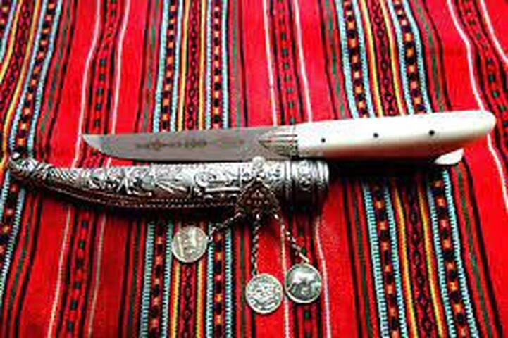
Sifaka
SifakaGETTING TO KNOW THE TRADITIONAL CRETAN KNIFE MAKERS OF CHANIA CITY
Armenis Shop
https://oarmenis.gr/en/
We have all heard a story about the famous Cretan knife, a tradition that continues today by some experienced craftsmen in the city of Chania.
You will find a wide variety of Cretan knives in the shops of Chania city, some of them even made with the original traditional method. Apart from being a basic tool, as it was always the case in Crete, the knife has also become a kind of souvenir for visitors to this beautiful island.
The best traditional knife makers in Chania, for centuries, are located around Sifaka Street, a small street on the northern part of the Splantzia neighborhood in the Old Town. Today, very few people are involved in traditional knife craftsmanship in Chania, which makes their handmade knives even rarer.
The knife has been a key tool for people all over the world for centuries. In Crete, however, the traditional knife craftsmen took their art to the next level, to the point that it became a key element of Cretan clothing and culture, but also a valuable product that was exported to the rest of Greece and abroad.
The handmade Cretan knives were – and still are – made by experienced craftsmen, who sculpt its stainless steel blade, process it carefully, and then create its handle and its sheath. Handmade knife craftsmanship has always been a difficult work, due to the high temperature and smoke in the workplace, and the frequent minor injuries suffered while working. This has discouraged many young craftsmen in the last decades from continuing to do this work.
A characteristic of Cretan knives is their forked handle, the opening of which is for the finger to hold and use it more steadily. Another characteristic is the V-shaped tip of their blade.
The most common traditional Cretan knife is the sharp “saita”. Many traditional Cretan knives have very special handles, e.g. from a goat’s horn, but also very elaborate sheaths, such as the ones made of pure silver masterfully carved, and which accompany rare “collectible” knives. If you look closely at the knives for sale in a traditional knife making workshop in Chania, you will be amazed by their great variety and the creative imagination the craftsmen have put into their making.
On the same street, you will find leather goods, clothes shops (Wipa's Shop with clothes and accessories from Thailand) café' shops overlooking the Byzantine Walls.
https://www.facebook.com/WipaSilkShop/.
Sifaka Street | Old Town, Chania Town, Crete, Greece
More of Crete, more of history!
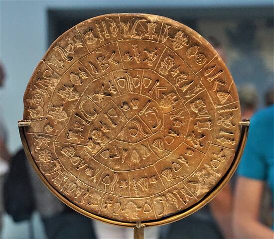
Crete
There is always more! This section is for archaeology/ history lovers.
Ancient Kydonia and Kastelli Hill
Chania/ Kydonia
In the modern city of Chania small sites have been excavated, the most important of which are on the Kastelli hill situated on top of the old Venetian harbour. This hill was occupied from the beginning of the Early Minoan Period right through to the end of the Late Minoan IIIC and beyond. Chania is one of the oldest continuously inhabited cities in the world and what became later known as Kastelli Hill, because of the Byzantine fortification (castle) that was built there, was the first place to be inhabited over 5000 years ago. Much later the Venetians established their headquarters there and so did the Turks. Unfortunately most of the district was destroyed by German bombings during WW2 and most of its old houses are gone. A number of buildings have been uncovered covering almost 5000 years of the history of the settlement of Chania. The main place for visitors to see are the excavations at Agia Ekaterini Square, only a few minutes on foot from the harbour.
Learn more:
http://minoancrete.com/chania.htm
6 Einheimische empfehlen
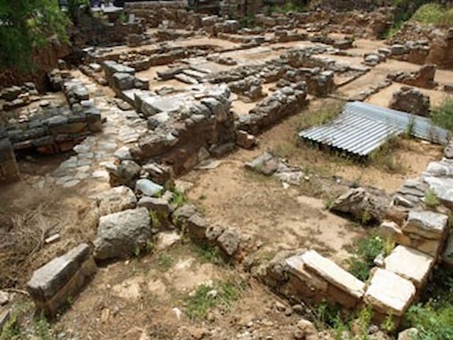
Chania Center
Ancient Kydonia and Kastelli Hill
Chania/ Kydonia
In the modern city of Chania small sites have been excavated, the most important of which are on the Kastelli hill situated on top of the old Venetian harbour. This hill was occupied from the beginning of the Early Minoan Period right through to the end of the Late Minoan IIIC and beyond. Chania is one of the oldest continuously inhabited cities in the world and what became later known as Kastelli Hill, because of the Byzantine fortification (castle) that was built there, was the first place to be inhabited over 5000 years ago. Much later the Venetians established their headquarters there and so did the Turks. Unfortunately most of the district was destroyed by German bombings during WW2 and most of its old houses are gone. A number of buildings have been uncovered covering almost 5000 years of the history of the settlement of Chania. The main place for visitors to see are the excavations at Agia Ekaterini Square, only a few minutes on foot from the harbour.
Learn more:
http://minoancrete.com/chania.htm
The Fortezza (Fortress) at Rethymno city
The Venetian Fortress is built on the “Paleokastro” hill, located on the west side of the city. The Acropolis of the ancient city of Rethymno was located on the same hill along with a sanctuary dedicated to Goddess Artemis. The Fortezza was built, between 1573-1580 by the Venetians, in order to protect the citizens from the Turkish threat. It is shaped like a star, it has three gates and six ramparts. The temple of Saint Nicolo was turned into the mosque of Imbraim Han. There was a building of the Commander, the building of the Counselor, army camps, stables, ammunition depots, a water supply reservoir and some houses that were later destroyed.
Fortezza
(16th century)
Castles & Fortresses, Cultural heritage
Address: Palaiokastro hill 74100 RETHYMNON , CRETE , GREECE
Tel.: +30 28310 40150-6, 23653, 58842
E-mail: 28eba@culture.gr
URL: http://odysseus.culture.gr/h/3/gh352.jsp...
Opening hours:
02Jan - 31Dec Mon-Sun, 0830-1500
Map:
https://archaeology-travel.com/destinations/europe/greece/interactive-map/?markerid=5059&mzoom=17
541 Einheimische empfehlen
Burg Fortezza
The Fortezza (Fortress) at Rethymno city
The Venetian Fortress is built on the “Paleokastro” hill, located on the west side of the city. The Acropolis of the ancient city of Rethymno was located on the same hill along with a sanctuary dedicated to Goddess Artemis. The Fortezza was built, between 1573-1580 by the Venetians, in order to protect the citizens from the Turkish threat. It is shaped like a star, it has three gates and six ramparts. The temple of Saint Nicolo was turned into the mosque of Imbraim Han. There was a building of the Commander, the building of the Counselor, army camps, stables, ammunition depots, a water supply reservoir and some houses that were later destroyed.
Fortezza
(16th century)
Castles & Fortresses, Cultural heritage
Address: Palaiokastro hill 74100 RETHYMNON , CRETE , GREECE
Tel.: +30 28310 40150-6, 23653, 58842
E-mail: 28eba@culture.gr
URL: http://odysseus.culture.gr/h/3/gh352.jsp...
Opening hours:
02Jan - 31Dec Mon-Sun, 0830-1500
Map:
https://archaeology-travel.com/destinations/europe/greece/interactive-map/?markerid=5059&mzoom=17
ARCHAEOLOGICAL MUSEUM OF HERAKLION
The archaeological museum in Heraklion is one of the largest and most important archaeology museums in Greece. Not only does the museum have extensive displays of some 7,000 years of Cretan prehistory, from the Neolithic to the Late Roman period, it also has the finest collection of Minoan art and artefacts. Some of the island’s most iconic objects can be seen in permanent exhibitions, these include the enigmatic Phaistos disk, the bull head rhyton from Zakros and bull leaping fresco from Knossos.
Learn more:
HTTPS://HERAKLIONMUSEUM.GR/LANGUAGE/EN/HOME/
LOCATION
Xanthoudidou & Hatzidaki str.
712 02 Heraklion – Crete, Greece
Tel.: 2810279000
Fax: 2810279001
474 Einheimische empfehlen
Archäologisches Museum Iraklio
1 ChatzidakiARCHAEOLOGICAL MUSEUM OF HERAKLION
The archaeological museum in Heraklion is one of the largest and most important archaeology museums in Greece. Not only does the museum have extensive displays of some 7,000 years of Cretan prehistory, from the Neolithic to the Late Roman period, it also has the finest collection of Minoan art and artefacts. Some of the island’s most iconic objects can be seen in permanent exhibitions, these include the enigmatic Phaistos disk, the bull head rhyton from Zakros and bull leaping fresco from Knossos.
Learn more:
HTTPS://HERAKLIONMUSEUM.GR/LANGUAGE/EN/HOME/
LOCATION
Xanthoudidou & Hatzidaki str.
712 02 Heraklion – Crete, Greece
Tel.: 2810279000
Fax: 2810279001
KNOSSOS
The center of Minoan civilization and capital of Minoan Crete lay 5km south of Heraklion.
Knossos flourished for approximately two thousand years. It had large palace buildings, extensive workshop installations and luxurious rock-cut cave and tholos tombs. As a major center of trade and the economy, Knossos maintained ties with the majority of cities in the Eastern Mediterranean.
Wealth accumulation and the advancement of an urban lifestyle were the hallmarks of this zenith, which began circa 2000 BC and was typified by magnificent monumental buildings and a complex social structure.
The Minoan palace is the main site of interest at Knossos, an important city in antiquity, which was inhabited continuously from the Neolithic period until the 5th c. AD. The palace was built on the Kephala hill and had easy access to the sea and the Cretan interior. According to tradition, it was the seat of the wise king Minos. The Palace of Knossos is connected with thrilling legends, such as the myth of the Labyrinth, with the Minotaur, and the story of Daedalus and Icarus.
Knossos is an important archaeological site that figures prominently in the history and development of archaeology. Excavations began in 1900 AD by Sir Arthur Evans and carried on for 35 years. Although many of his reconstructions and interpretations are now questioned, it is thought that the ruins are those of a political and ceremonial center that was at the heart of Bronze Age communities on Crete. There is also archaeological evidence at the site for Neolithic and later Classical occupations.
For more information:
http://www.minoancrete.com/knossos.htm
http://odysseus.culture.gr/h/3/eh355.jsp?obj_id=2369
https://mapcarta.com/12864934/Map
https://visitknossos.com/destination/tour-to-knossos/join-a-small-group-for-your-knossos-tour/
407 Einheimische empfehlen
Knossos
KNOSSOS
The center of Minoan civilization and capital of Minoan Crete lay 5km south of Heraklion.
Knossos flourished for approximately two thousand years. It had large palace buildings, extensive workshop installations and luxurious rock-cut cave and tholos tombs. As a major center of trade and the economy, Knossos maintained ties with the majority of cities in the Eastern Mediterranean.
Wealth accumulation and the advancement of an urban lifestyle were the hallmarks of this zenith, which began circa 2000 BC and was typified by magnificent monumental buildings and a complex social structure.
The Minoan palace is the main site of interest at Knossos, an important city in antiquity, which was inhabited continuously from the Neolithic period until the 5th c. AD. The palace was built on the Kephala hill and had easy access to the sea and the Cretan interior. According to tradition, it was the seat of the wise king Minos. The Palace of Knossos is connected with thrilling legends, such as the myth of the Labyrinth, with the Minotaur, and the story of Daedalus and Icarus.
Knossos is an important archaeological site that figures prominently in the history and development of archaeology. Excavations began in 1900 AD by Sir Arthur Evans and carried on for 35 years. Although many of his reconstructions and interpretations are now questioned, it is thought that the ruins are those of a political and ceremonial center that was at the heart of Bronze Age communities on Crete. There is also archaeological evidence at the site for Neolithic and later Classical occupations.
For more information:
http://www.minoancrete.com/knossos.htm
http://odysseus.culture.gr/h/3/eh355.jsp?obj_id=2369
https://mapcarta.com/12864934/Map
https://visitknossos.com/destination/tour-to-knossos/join-a-small-group-for-your-knossos-tour/
PHAISTOS
Phaistos was an important center of Minoan civilization on the island of Crete, the wealthiest and most powerful in southern Crete. At the center of the substantial Minoan city was, according to many archaeologists, the finest of all the Minoan palaces. The earliest evidence of habitation dates to the Neolithic, while the first palace was constructed during the 15th century BC. Of a much more recent age are the archaeological remains of the Venetian church of St. George of Phalandra.
For more information:
http://www.minoancrete.com/phaistos.htm
https://www.interkriti.org/crete/iraklion/phaistos.html
http://odysseus.culture.gr/h/3/eh355.jsp?obj_id=2363
https://mapcarta.com/12870740
76 Einheimische empfehlen
Minoischer Palast von Phaistos
Eparchiaki Odos Faistou - Kalon LimenonPHAISTOS
Phaistos was an important center of Minoan civilization on the island of Crete, the wealthiest and most powerful in southern Crete. At the center of the substantial Minoan city was, according to many archaeologists, the finest of all the Minoan palaces. The earliest evidence of habitation dates to the Neolithic, while the first palace was constructed during the 15th century BC. Of a much more recent age are the archaeological remains of the Venetian church of St. George of Phalandra.
For more information:
http://www.minoancrete.com/phaistos.htm
https://www.interkriti.org/crete/iraklion/phaistos.html
http://odysseus.culture.gr/h/3/eh355.jsp?obj_id=2363
https://mapcarta.com/12870740
GORTYNA
Although a flourishing city was mentioned by Homer, it was not until the Hellenistic era that the city of Gortyn was at its most prosperous and powerful. During the Roman period the city became the capital city of the province of Creta et Cyrenaica. Later, in the sixth century AD a Christian cathedral was erected and dedicated to St Titus, the substantial ruins of which can still be seen today. Today, the site is best known for the Gortyn Code, discovered in 1884 it is the most complete and oldest example of a code of ancient Greek law.
Gortyna was first inhabited at the end of the Neolithic period (3000 BC) and by the Late Minoan period (1600-1100 BC) it became a flourishing settlement. Remains of the archaic period (7th century BC) were located in the area of the Acropolis, while the large inscription, the Gortyn Law Code, dated to the 5th century BC, attests the prosperity of the city, which continued throughout the historical times. However Gortyna reached its peak during the Roman era (1st - 5th centuries AD), as an ally of Rome and the capital of the Roman provinces of Crete and Cyrene. The city remained an important center of Crete in the following Early Byzantine period and, according to tradition, it was the first Cretan city which espoused Christianity. Gortyna became the seat of the first bishop of Crete, Apostle Titus, to whom was dedicated a monumental temple. The conquest of Crete by the Arabs put an end, in 824 AD, to the history of the ancient Gortyna.
The first archaeological research on the site was conducted in 1884 by the Italian archaeologist F. Halbherr. Since then, excavations have been carried out by the Italian Archaeological School and the local Archaeological Service.
The most important monuments of the site are:
- The Odeion. It is a typical Roman theatre of the 1st century AD with two entrances on the north side and an almost semicircular orchestra. The north wall of the formerly raised skene (stage) had four niches for statues.
- The Gortyna Law Code. The inscription with the Code is to be seen in the north round wall of the Odeion, sheltered in a small structure. It is a complete code of law, based on Minoan tradition,dated to 450 B.C, which survives the Doric city .
- Isieion. The sanctuary of the Egyptian Divinities (1st-2nd centuries AD) is a rectangular area dedicated to the cult of many gods, such as Isis, Serapis-Zeus and Anubis-Hermes. It had an underground cistern.
- Temple of Apollo Pythios. It was built in the archaic period (7th century BC) and originally was a rectangular house with a treasury. In the following, Hellenistic and Roman periods (4th century BC-2nd century AD) several additions were made to the building, including the prodomos, the colonnades, and a conch which sheltered the statue of Pythios Apollo.
- The Praetorium was the seat and residence of the proconsul of Crete. It is divided into two parts: the administrative section, in which the central building is the basilica, and the residential section. The preserved ruins are dated to the 2nd century AD and seem to have been repaired in the 4th century AD.
- The northeastern cistern and the Nymphaeum. They lie immediately to the north of the Praetorium. The first cistern was a rectangular, open-air structure with conches on all sides, where the statues of Nymphs were placed. It was converted into a vaulted cistern in the 7th century AD.
- The Acropolis on the hill of Agios Ioannis. Large sections of a polygonal fortification wall are preserved with towers at the corners (10th-6th centuries BC). Within the enclosed area there was an archaic temple, on the ruins of which an Early Christian basilica was later erected.
- The Church of St. Titus. It is a cross - shaped three - aisled basilica with cupola; the northern and the southern arm of the cross end up in conchs. The church was built with rectangular hewn stones and is dated in the 7th century AD. It was destroyed by the Arabs in 824 AD and rebuilt after the recapture of Crete by the Byzantines during the 10th century.
- Triconch church founded probably over the tomb of the Ten Cretan Martyrs. The narthex communicates through a tribelon with the central rectangular part of the church. The mosaic floor and the remaining capitals are exquisite. The church is dated in the 5th century AD.
Administrative Information
Official Unit:
23rd Ephorate of Prehistoric and Classical Antiquities
Τ.Κ. 70200, Faistos (Prefecture of Iraklio)
Telephone: +30 28920 42315
Email: protocol@kgepka.culture.gr
Tickets
Full: €4, Reduced: €2
Special ticket package: Full: €6, Reduced: €3
Valid for: Phaistos and the Royal villa at Agia Triada
https://mapcarta.com/28613566
26 Einheimische empfehlen
Archaeological Site of Gortyna
ΓόρτυςGORTYNA
Although a flourishing city was mentioned by Homer, it was not until the Hellenistic era that the city of Gortyn was at its most prosperous and powerful. During the Roman period the city became the capital city of the province of Creta et Cyrenaica. Later, in the sixth century AD a Christian cathedral was erected and dedicated to St Titus, the substantial ruins of which can still be seen today. Today, the site is best known for the Gortyn Code, discovered in 1884 it is the most complete and oldest example of a code of ancient Greek law.
Gortyna was first inhabited at the end of the Neolithic period (3000 BC) and by the Late Minoan period (1600-1100 BC) it became a flourishing settlement. Remains of the archaic period (7th century BC) were located in the area of the Acropolis, while the large inscription, the Gortyn Law Code, dated to the 5th century BC, attests the prosperity of the city, which continued throughout the historical times. However Gortyna reached its peak during the Roman era (1st - 5th centuries AD), as an ally of Rome and the capital of the Roman provinces of Crete and Cyrene. The city remained an important center of Crete in the following Early Byzantine period and, according to tradition, it was the first Cretan city which espoused Christianity. Gortyna became the seat of the first bishop of Crete, Apostle Titus, to whom was dedicated a monumental temple. The conquest of Crete by the Arabs put an end, in 824 AD, to the history of the ancient Gortyna.
The first archaeological research on the site was conducted in 1884 by the Italian archaeologist F. Halbherr. Since then, excavations have been carried out by the Italian Archaeological School and the local Archaeological Service.
The most important monuments of the site are:
- The Odeion. It is a typical Roman theatre of the 1st century AD with two entrances on the north side and an almost semicircular orchestra. The north wall of the formerly raised skene (stage) had four niches for statues.
- The Gortyna Law Code. The inscription with the Code is to be seen in the north round wall of the Odeion, sheltered in a small structure. It is a complete code of law, based on Minoan tradition,dated to 450 B.C, which survives the Doric city .
- Isieion. The sanctuary of the Egyptian Divinities (1st-2nd centuries AD) is a rectangular area dedicated to the cult of many gods, such as Isis, Serapis-Zeus and Anubis-Hermes. It had an underground cistern.
- Temple of Apollo Pythios. It was built in the archaic period (7th century BC) and originally was a rectangular house with a treasury. In the following, Hellenistic and Roman periods (4th century BC-2nd century AD) several additions were made to the building, including the prodomos, the colonnades, and a conch which sheltered the statue of Pythios Apollo.
- The Praetorium was the seat and residence of the proconsul of Crete. It is divided into two parts: the administrative section, in which the central building is the basilica, and the residential section. The preserved ruins are dated to the 2nd century AD and seem to have been repaired in the 4th century AD.
- The northeastern cistern and the Nymphaeum. They lie immediately to the north of the Praetorium. The first cistern was a rectangular, open-air structure with conches on all sides, where the statues of Nymphs were placed. It was converted into a vaulted cistern in the 7th century AD.
- The Acropolis on the hill of Agios Ioannis. Large sections of a polygonal fortification wall are preserved with towers at the corners (10th-6th centuries BC). Within the enclosed area there was an archaic temple, on the ruins of which an Early Christian basilica was later erected.
- The Church of St. Titus. It is a cross - shaped three - aisled basilica with cupola; the northern and the southern arm of the cross end up in conchs. The church was built with rectangular hewn stones and is dated in the 7th century AD. It was destroyed by the Arabs in 824 AD and rebuilt after the recapture of Crete by the Byzantines during the 10th century.
- Triconch church founded probably over the tomb of the Ten Cretan Martyrs. The narthex communicates through a tribelon with the central rectangular part of the church. The mosaic floor and the remaining capitals are exquisite. The church is dated in the 5th century AD.
Administrative Information
Official Unit:
23rd Ephorate of Prehistoric and Classical Antiquities
Τ.Κ. 70200, Faistos (Prefecture of Iraklio)
Telephone: +30 28920 42315
Email: protocol@kgepka.culture.gr
Tickets
Full: €4, Reduced: €2
Special ticket package: Full: €6, Reduced: €3
Valid for: Phaistos and the Royal villa at Agia Triada
https://mapcarta.com/28613566
The Minoan Palace and the archaeological site of Malia
The Minoan Palace and the archaeological site of Malia are located 3 km East of the town of Malia. From the architectural point of view the Palace of Malia, is the third- largest of the Minoan Palaces and is considered the most "provincial" of them. It covered an area of 7,500 sqm. and according to tradition the third son of Zeus and Europa, Sarpedon, brother of the legendary king Minos, ruled here.
The Palace had two floors and its entrance is from the western paved Court, through a procession passage. It is a building with a central court, loggia, theatre, sanctuaries, Royal quarters, workshops and magazines. North of the western court is the hypostyle crypt, discovered recently, and protected from the weather conditions by a modern roof. The large underground room, whose ceiling was supported by columns, is considered as a council chamber for the political deliberations of the local lords, separated from the dwelling quarters and the official buildings. It’s a forebear of the classical Greek Pritaneion, which had a similar function.
For more information:
HTTP://WWW.MINOANCRETE.COM/MALIA.HTM
Administrative Information
Official Unit:
23rd Ephorate of Prehistoric and Classical Antiquities
Τ.Κ. 70007, Malia (Prefecture of Iraklion)
Telephone: +30 2897 031597
Email: protocol@kgepka.culture.gr
Website: www.culture.gr
Tickets: Full: €4
HTTPS://MAPCARTA.COM/MALIA
94 Einheimische empfehlen
Archäologische Stätte des Malia-Palastes
The Minoan Palace and the archaeological site of Malia
The Minoan Palace and the archaeological site of Malia are located 3 km East of the town of Malia. From the architectural point of view the Palace of Malia, is the third- largest of the Minoan Palaces and is considered the most "provincial" of them. It covered an area of 7,500 sqm. and according to tradition the third son of Zeus and Europa, Sarpedon, brother of the legendary king Minos, ruled here.
The Palace had two floors and its entrance is from the western paved Court, through a procession passage. It is a building with a central court, loggia, theatre, sanctuaries, Royal quarters, workshops and magazines. North of the western court is the hypostyle crypt, discovered recently, and protected from the weather conditions by a modern roof. The large underground room, whose ceiling was supported by columns, is considered as a council chamber for the political deliberations of the local lords, separated from the dwelling quarters and the official buildings. It’s a forebear of the classical Greek Pritaneion, which had a similar function.
For more information:
HTTP://WWW.MINOANCRETE.COM/MALIA.HTM
Administrative Information
Official Unit:
23rd Ephorate of Prehistoric and Classical Antiquities
Τ.Κ. 70007, Malia (Prefecture of Iraklion)
Telephone: +30 2897 031597
Email: protocol@kgepka.culture.gr
Website: www.culture.gr
Tickets: Full: €4
HTTPS://MAPCARTA.COM/MALIA
The Zakros Palace in the region of Zakros
The Zakros Palace in Crete is one of the latest vestiges of the ancient Minoan civilization that was unearthed in our time. Zakros Palace is the last of the Minoan Palaces that has come into light as a whole.
The site of this Minoan palace is situated on Crete’s eastern coast, in the region of Zakros, just south of Palaikastro, another interesting Minoan settlement.
Of the four Minoan palaces to be discovered by archaeologists – the others being Malia, Phaistos and, of course, Knossos – the palace of Zakros is the smallest. The palace itself covered an extension of 4,500 square meters and crowned a flourishing urban center with an area of over 8,000 square meters as a whole. However Zakros Palace is only a fifth of the size of Knossos, the latter being the largest of the Minoan palaces in Crete and the center of the Minoan civilization in general.
For more information:
http://www.minoancrete.com/zakros.htm
http://odysseus.culture.gr/h/3/eh355.jsp?obj_id=2376
https://mapcarta.com/Zakros
15 Einheimische empfehlen
Minoan Palace of Zakros
The Zakros Palace in the region of Zakros
The Zakros Palace in Crete is one of the latest vestiges of the ancient Minoan civilization that was unearthed in our time. Zakros Palace is the last of the Minoan Palaces that has come into light as a whole.
The site of this Minoan palace is situated on Crete’s eastern coast, in the region of Zakros, just south of Palaikastro, another interesting Minoan settlement.
Of the four Minoan palaces to be discovered by archaeologists – the others being Malia, Phaistos and, of course, Knossos – the palace of Zakros is the smallest. The palace itself covered an extension of 4,500 square meters and crowned a flourishing urban center with an area of over 8,000 square meters as a whole. However Zakros Palace is only a fifth of the size of Knossos, the latter being the largest of the Minoan palaces in Crete and the center of the Minoan civilization in general.
For more information:
http://www.minoancrete.com/zakros.htm
http://odysseus.culture.gr/h/3/eh355.jsp?obj_id=2376
https://mapcarta.com/Zakros
The Palace of Galatas
The Palace at Galatas is a Minoan archaeological site 27km south of Heraklion city.
It is located near the villages of Galatas and Arkalochori with fine views of the surrounding countryside.
It was discovered and excavated in 1992.
In 1997 the archaeologist responsible, George Rethemiotakis, announced that the main building had all the characteristics of a Minoan palace which was built only in one period, the neopalatial.
Excavations were completed in 2005 although they continue in buildings outside the palace itself.
The large, central courtyard of the palace was originally surrounded by a four-wing building.
The East Wing is the best preserved part of the building, while the West and South wings have been extensively damaged.
The north wing has now also been excavated.
Excavations in the East wing brought to light grinders and hundreds of drinking vessels, which suggested that feasting ceremonies took place.
For the first time in Minoan Crete, a hearth was discovered together with a layer of ash in one of the rooms.
The Palace flourished during 1640 BC but was destroyed by earthquakes and abandoned around 1500 BC.
FOR MORE INFORMATION:
HTTP://WWW.MINOANCRETE.COM/GALATAS.HTM
HTTPS://MAPCARTA.COM/W886803052
HTTP://ODYSSEUS.CULTURE.GR/H/2/EH255.JSP?OBJ_ID=7135
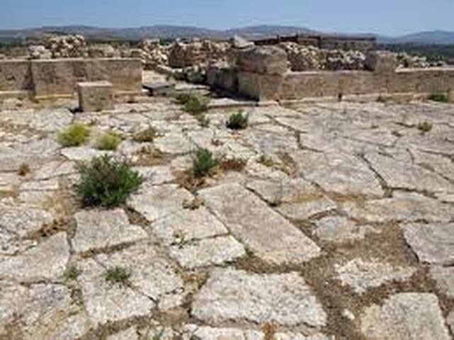
Galatas Minoan Palace
The Palace of Galatas
The Palace at Galatas is a Minoan archaeological site 27km south of Heraklion city.
It is located near the villages of Galatas and Arkalochori with fine views of the surrounding countryside.
It was discovered and excavated in 1992.
In 1997 the archaeologist responsible, George Rethemiotakis, announced that the main building had all the characteristics of a Minoan palace which was built only in one period, the neopalatial.
Excavations were completed in 2005 although they continue in buildings outside the palace itself.
The large, central courtyard of the palace was originally surrounded by a four-wing building.
The East Wing is the best preserved part of the building, while the West and South wings have been extensively damaged.
The north wing has now also been excavated.
Excavations in the East wing brought to light grinders and hundreds of drinking vessels, which suggested that feasting ceremonies took place.
For the first time in Minoan Crete, a hearth was discovered together with a layer of ash in one of the rooms.
The Palace flourished during 1640 BC but was destroyed by earthquakes and abandoned around 1500 BC.
FOR MORE INFORMATION:
HTTP://WWW.MINOANCRETE.COM/GALATAS.HTM
HTTPS://MAPCARTA.COM/W886803052
HTTP://ODYSSEUS.CULTURE.GR/H/2/EH255.JSP?OBJ_ID=7135
THE MINOAN PALACE OF PETRAS (SITIA)
The Minoan settlement of Petras was built on a low hill overlooking the present City of Sitia It is believed by many researchers that this was the site of ancient Etea or Etida, from where the sage Myson came from. The town was excavated since 1985 by the archaeologist M. Tsipopoulou. Archaeologists founds parts of the Cyclopean wall with three square towers, two houses and a Minoan palace.
Petras flourished since the 20th century BC and quickly developed into an urban settlement with foremost commercial significance, as evidenced by the hieroglyph file found in excellent condition. After the destruction of the palace in 1450 BC, the hill remained inhabited and the defensive cyclopean wall was built. 40 large jars (pithi) were also found here, such as those found in all the Minoan palaces of Crete.
For more information:
http://www.minoancrete.com/petras.htm
https://mapcarta.com/12856538
http://odysseus.culture.gr/h/3/eh355.jsp?obj_id=2447
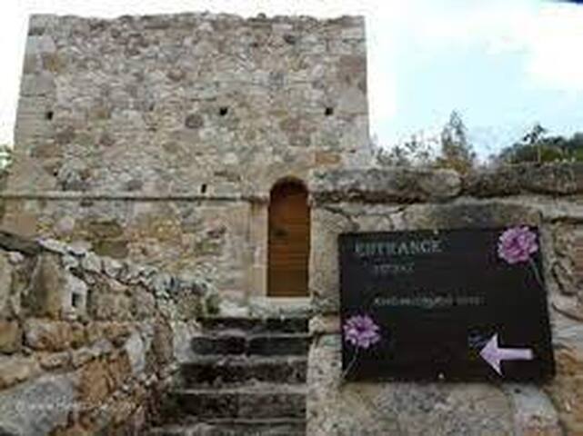
Petras Minoan, Archeological Area
THE MINOAN PALACE OF PETRAS (SITIA)
The Minoan settlement of Petras was built on a low hill overlooking the present City of Sitia It is believed by many researchers that this was the site of ancient Etea or Etida, from where the sage Myson came from. The town was excavated since 1985 by the archaeologist M. Tsipopoulou. Archaeologists founds parts of the Cyclopean wall with three square towers, two houses and a Minoan palace.
Petras flourished since the 20th century BC and quickly developed into an urban settlement with foremost commercial significance, as evidenced by the hieroglyph file found in excellent condition. After the destruction of the palace in 1450 BC, the hill remained inhabited and the defensive cyclopean wall was built. 40 large jars (pithi) were also found here, such as those found in all the Minoan palaces of Crete.
For more information:
http://www.minoancrete.com/petras.htm
https://mapcarta.com/12856538
http://odysseus.culture.gr/h/3/eh355.jsp?obj_id=2447
Minoan palatial centre at Monastiraki
On the west foothills of Mount Ida, the tallest in Crete, an important Old Palace settlement has been unearthed just outside Monastiraki, in the region of Amari. The distance from Rethymno is 35 km and you can combine it with a visit to nearby Arkadi Monastery that is on the way. The archaeological site is tucked away just outside the village and parts of it are still being unearthed.
At the centre of the settlement, there is a large two-storey building complex with palatial characteristics. It was possibly built around 2000 BC and was destroyed violently, like many of the old Minoan palaces, circa 1700 BC, most likely due to an earthquake and/or a fire. Excavations have uncovered storerooms, ritual rooms, and other areas in which a large number of clay sealings were found. This fact suggests that these rooms probably housed the archives of the palatial centre. Articles of Pottery found in the settlement of Monastiraki resemble those unearthed in Phaistos. This provides another strong indication that these two centers probably shared financial and commercial relationships. In addition, the palatial structure had a drainage system and resembled the architecture and urban planning of Phaistos palace.
It is not clear whether Monastiraki was a Minoan palace or a settlement due to lack of houses in the area, however, most evidence supports this theory. Another possibility is that Monastiraki operated as an outpost of Phaistos but it could also have an independent ruler. The ancient name of this site has not been ascertained. Because it was never rebuilt after it was destroyed, the site has provided archaeologists with a wealth of finds that were not affected by remodeling or rebuilding. The total area covers more than 300,000 square meters but only a small portion has been excavated so far. Systematic excavations began in 1980 under the auspices of the University of Crete and Athanasia Kanta. Previously, illegal excavations also took place in World War II during the German occupation.
Monastiraki is also the E4 European trail Path .The section that crosses it starts in the village of Gerakari and takes you through Amari and onto Fourfouras. From there you can choose to hike to the summit of Mount Ida.
For more information:
http://www.minoancrete.com/monastiraki.htm
https://mapcarta.com/12859306
Minoan palatial complex (ca. 2000-1700 BC)
Archaeological site, Cultural heritage
Address: Kokkinos Xarakas location 74061 MONASTIRAKI , RETHYMNO , GREECE
Tel.: +30 28310 29975
E-mail: reth.keepka@culture.gr
http://www.ics.forth.gr/isl/yppo_site/fo...
Opening hours:
01Jun - 31Oct Tue-Sun, 0800-1500
01Nov - 31May Tue-Sun, 0830-1500
________________________________________________________
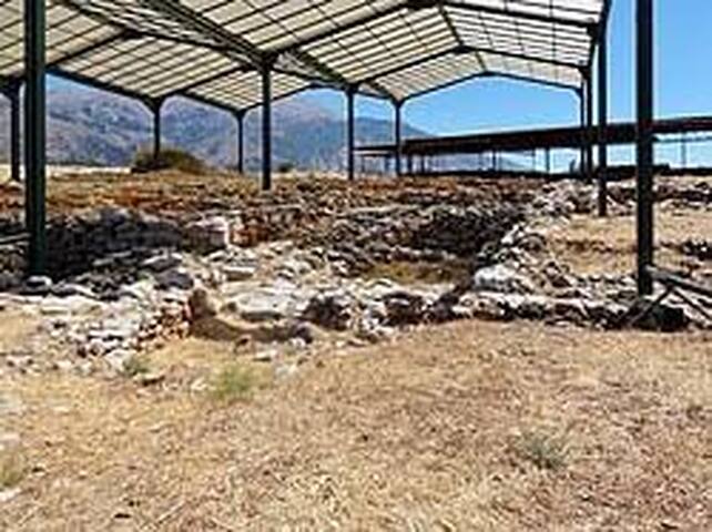
Monastiraki
Minoan palatial centre at Monastiraki
On the west foothills of Mount Ida, the tallest in Crete, an important Old Palace settlement has been unearthed just outside Monastiraki, in the region of Amari. The distance from Rethymno is 35 km and you can combine it with a visit to nearby Arkadi Monastery that is on the way. The archaeological site is tucked away just outside the village and parts of it are still being unearthed.
At the centre of the settlement, there is a large two-storey building complex with palatial characteristics. It was possibly built around 2000 BC and was destroyed violently, like many of the old Minoan palaces, circa 1700 BC, most likely due to an earthquake and/or a fire. Excavations have uncovered storerooms, ritual rooms, and other areas in which a large number of clay sealings were found. This fact suggests that these rooms probably housed the archives of the palatial centre. Articles of Pottery found in the settlement of Monastiraki resemble those unearthed in Phaistos. This provides another strong indication that these two centers probably shared financial and commercial relationships. In addition, the palatial structure had a drainage system and resembled the architecture and urban planning of Phaistos palace.
It is not clear whether Monastiraki was a Minoan palace or a settlement due to lack of houses in the area, however, most evidence supports this theory. Another possibility is that Monastiraki operated as an outpost of Phaistos but it could also have an independent ruler. The ancient name of this site has not been ascertained. Because it was never rebuilt after it was destroyed, the site has provided archaeologists with a wealth of finds that were not affected by remodeling or rebuilding. The total area covers more than 300,000 square meters but only a small portion has been excavated so far. Systematic excavations began in 1980 under the auspices of the University of Crete and Athanasia Kanta. Previously, illegal excavations also took place in World War II during the German occupation.
Monastiraki is also the E4 European trail Path .The section that crosses it starts in the village of Gerakari and takes you through Amari and onto Fourfouras. From there you can choose to hike to the summit of Mount Ida.
For more information:
http://www.minoancrete.com/monastiraki.htm
https://mapcarta.com/12859306
Minoan palatial complex (ca. 2000-1700 BC)
Archaeological site, Cultural heritage
Address: Kokkinos Xarakas location 74061 MONASTIRAKI , RETHYMNO , GREECE
Tel.: +30 28310 29975
E-mail: reth.keepka@culture.gr
http://www.ics.forth.gr/isl/yppo_site/fo...
Opening hours:
01Jun - 31Oct Tue-Sun, 0800-1500
01Nov - 31May Tue-Sun, 0830-1500
________________________________________________________
SPINALONGA ( ELOUNDA)
Although the island of Spinalonga has a fascinating Venetian and Ottoman history, it is better known today as a result of being the setting of Victoria Hislop’s 2005 novel The Island. The story, also adapted for TV, explore the novelist’s family ties to the island. An island on which those who suffered leprosy were quarantined from 1903 to 1957. Now the island is a popular day trip for tourists staying in Crete. Besides the ruined features of the hospital, visitors can also explore the Venetian fortress, which was one of the most important in the Mediterranean because of its strategic location.
Spinalonga island. Started as a Venetian fortress (1574-1715), became an Ottoman colony (1715-1898) after the Venetian-Ottoman wars. Spinalonga was not always an island. It is believed that in 1526, the Venetians destroyed part of the peninsula of Elounda to create an island, which was reinforced to safeguard the port of ancient Olous.( Elounda has a rich history that starts with the ancient city of Olous or Olounda. This ancient city sank into the sea, and its remnants are still visible when the sea is calm. Olous was the most powerful, fortified city-state near Lato, one of the greatest of the island, with a port and its own currency. The glorious past of ancient Olous was abruptly disrupted by a powerful earthquake in 780 AD.)
Olous had remained uninhabited until the mid-15th century when it earned commercial value due to its salt pans. The inhibition of the city, along with the pirate raids and the Turkish threat, made the fortification a necessity and resulted in Spinalonga becoming one of the most powerful sea fortresses in the Mediterranean.
Spinalonga remained under Venetian rule even after the rest of Crete was occupied by the Ottomans. In 1715, however, the Ottomans managed to overthrow the small island, banishing the Venetian presence from Crete completely. Eventually, in 1903, the Turkish left the island and it became once again a part of Greece.
This is why Spinalonga is known across the world as the host of the leper community from 1903 to 1957, and as one of the last active leper colonies in Europe, reaching a number of almost 400 inhabitants during the outbreak of the illness. It was also one of the few places in Europe that the Germans wouldn’t occupy during WWII
Those that contracted leprosy were sent there to isolate and to wait for their death.
For more information:
http://www.crete-guide.info/Spinalonga.htm
http://odysseus.culture.gr/h/3/eh355.jsp?obj_id=2607
99 Einheimische empfehlen
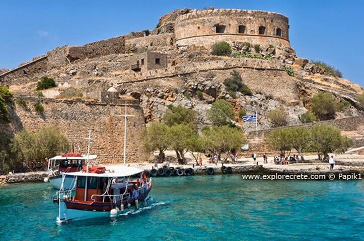
Nisida Spinalonga
SPINALONGA ( ELOUNDA)
Although the island of Spinalonga has a fascinating Venetian and Ottoman history, it is better known today as a result of being the setting of Victoria Hislop’s 2005 novel The Island. The story, also adapted for TV, explore the novelist’s family ties to the island. An island on which those who suffered leprosy were quarantined from 1903 to 1957. Now the island is a popular day trip for tourists staying in Crete. Besides the ruined features of the hospital, visitors can also explore the Venetian fortress, which was one of the most important in the Mediterranean because of its strategic location.
Spinalonga island. Started as a Venetian fortress (1574-1715), became an Ottoman colony (1715-1898) after the Venetian-Ottoman wars. Spinalonga was not always an island. It is believed that in 1526, the Venetians destroyed part of the peninsula of Elounda to create an island, which was reinforced to safeguard the port of ancient Olous.( Elounda has a rich history that starts with the ancient city of Olous or Olounda. This ancient city sank into the sea, and its remnants are still visible when the sea is calm. Olous was the most powerful, fortified city-state near Lato, one of the greatest of the island, with a port and its own currency. The glorious past of ancient Olous was abruptly disrupted by a powerful earthquake in 780 AD.)
Olous had remained uninhabited until the mid-15th century when it earned commercial value due to its salt pans. The inhibition of the city, along with the pirate raids and the Turkish threat, made the fortification a necessity and resulted in Spinalonga becoming one of the most powerful sea fortresses in the Mediterranean.
Spinalonga remained under Venetian rule even after the rest of Crete was occupied by the Ottomans. In 1715, however, the Ottomans managed to overthrow the small island, banishing the Venetian presence from Crete completely. Eventually, in 1903, the Turkish left the island and it became once again a part of Greece.
This is why Spinalonga is known across the world as the host of the leper community from 1903 to 1957, and as one of the last active leper colonies in Europe, reaching a number of almost 400 inhabitants during the outbreak of the illness. It was also one of the few places in Europe that the Germans wouldn’t occupy during WWII
Those that contracted leprosy were sent there to isolate and to wait for their death.
For more information:
http://www.crete-guide.info/Spinalonga.htm
http://odysseus.culture.gr/h/3/eh355.jsp?obj_id=2607