
Erik’s guidebook
Food scene
This restaurant has some of the best tasting Chinese-American food you might ever eat. Give it a try if you're craving Chinese-American Cuisine.
Butterfly Restaurant
831 Farmington AveThis restaurant has some of the best tasting Chinese-American food you might ever eat. Give it a try if you're craving Chinese-American Cuisine.
Sightseeing
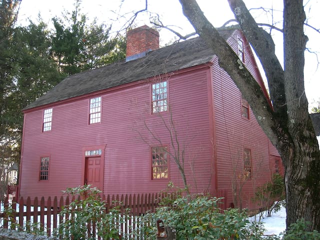
The Mark Twain House and Museum in Hartford, Connecticut, was the home of Samuel Langhorne Clemens and his family from 1874 to 1891. It was designed by Edward Tuckerman Potter and built in the American High Gothic style. Clemens biographer Justin Kaplan has called it "part steamboat, part medieval fortress and part cuckoo clock." Clemens wrote many of his best-known works while living there, including The Adventures of Tom Sawyer, The Prince and the Pauper, Life on the Mississippi, Adventures of Huckleberry Finn, A Tramp Abroad, and A Connecticut Yankee in King Arthur's Court. Poor financial investments prompted the Clemens family to move to Europe in 1891. The Panic of 1893 further threatened their financial stability, and Clemens, his wife Olivia, and their middle daughter, Clara, spent the year 1895-96 traveling so that he could lecture and earn the money to pay off their debts. He recounted the trip in Following the Equator. Their other two daughters, Susy and Jean, had stayed behind during this time, and Susy died at home on August 18, 1896 of spinal meningitis before the family could be reunited.
104 Einheimische empfehlen
Mark Twain House
351 Farmington AveThe Mark Twain House and Museum in Hartford, Connecticut, was the home of Samuel Langhorne Clemens and his family from 1874 to 1891. It was designed by Edward Tuckerman Potter and built in the American High Gothic style. Clemens biographer Justin Kaplan has called it "part steamboat, part medieval fortress and part cuckoo clock." Clemens wrote many of his best-known works while living there, including The Adventures of Tom Sawyer, The Prince and the Pauper, Life on the Mississippi, Adventures of Huckleberry Finn, A Tramp Abroad, and A Connecticut Yankee in King Arthur's Court. Poor financial investments prompted the Clemens family to move to Europe in 1891. The Panic of 1893 further threatened their financial stability, and Clemens, his wife Olivia, and their middle daughter, Clara, spent the year 1895-96 traveling so that he could lecture and earn the money to pay off their debts. He recounted the trip in Following the Equator. Their other two daughters, Susy and Jean, had stayed behind during this time, and Susy died at home on August 18, 1896 of spinal meningitis before the family could be reunited.
The Connecticut Historical Society is a private, non-profit organization that serves as the official statewide historical society of Connecticut. Established in Hartford in 1825, the CHS is one of the oldest historical societies in the US. The Connecticut Historical Society is a non-profit museum, library, archive and education center that is open to the public. The CHS houses a research center containing 270,000 artifacts and graphics and over 100,000 books and pamphlets. It has one of the largest costume and textile collections in New England.
10 Einheimische empfehlen
Connecticut Historical Society
1 Elizabeth StThe Connecticut Historical Society is a private, non-profit organization that serves as the official statewide historical society of Connecticut. Established in Hartford in 1825, the CHS is one of the oldest historical societies in the US. The Connecticut Historical Society is a non-profit museum, library, archive and education center that is open to the public. The CHS houses a research center containing 270,000 artifacts and graphics and over 100,000 books and pamphlets. It has one of the largest costume and textile collections in New England.
Rentschler Field was an airport in East Hartford, Connecticut in use from 1933 to 1999. Originally a military facility, later a private corporate airport, it was decommissioned in 1999, after which the football stadium of the same name was built on the site. From 1930 to 1939, the Chance Vought Aircraft Corporations's manufacturing facility was located here, as was the Pratt & Whitney Aircraft Company and the Hamilton Standard Propellers Corporation.
During World War II the airfield was used by the United States Army Air Forces First Air Force as a fighter base, providing coastal air defense over the Atlantic Ocean. After the war, the airfield was returned to civilian use.
Rentschler Field was decommissioned as an airport and donated to the state of Connecticut by United Technologies in 1999. Part of the former airport became the University of Connecticut's new football stadium, Rentschler Field.
9 Einheimische empfehlen
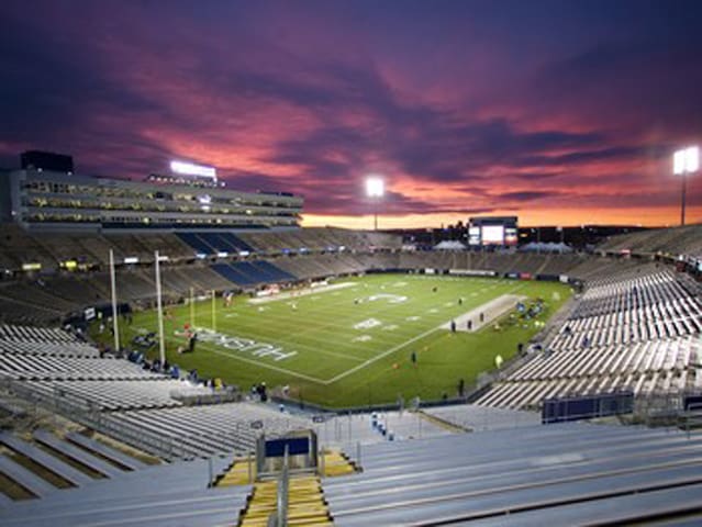
Rentschler Field
615 Silver LnRentschler Field was an airport in East Hartford, Connecticut in use from 1933 to 1999. Originally a military facility, later a private corporate airport, it was decommissioned in 1999, after which the football stadium of the same name was built on the site. From 1930 to 1939, the Chance Vought Aircraft Corporations's manufacturing facility was located here, as was the Pratt & Whitney Aircraft Company and the Hamilton Standard Propellers Corporation.
During World War II the airfield was used by the United States Army Air Forces First Air Force as a fighter base, providing coastal air defense over the Atlantic Ocean. After the war, the airfield was returned to civilian use.
Rentschler Field was decommissioned as an airport and donated to the state of Connecticut by United Technologies in 1999. Part of the former airport became the University of Connecticut's new football stadium, Rentschler Field.
Pratt & Whitney Stadium at Rentschler Field is a stadium in East Hartford, Connecticut. It is primarily used for football and soccer, and is the home field of the University of Connecticut (UConn) Huskies. It may also host the Connecticut Underground of the Freedom Football League; in the fall of 2010, it was home to the Hartford Colonials of the United Football League. The stadium, which opened in 2003, was the first stadium used primarily by an NCAA Division I-A (now FBS) team to open in the 21st century. The permanent stadium capacity is 40,000, consisting of 38,066 permanent seats with a standing-room area in the scoreboard plaza that can accommodate up to 1,934 people. It also has a game day capability to add approximately 2,000 temporary seats as it did for UConn football vs. Michigan in 2013. Connecticut played on campus at Memorial Stadium in Storrs, before 2003.
Rentschler Field was originally the name of the company airfield for Pratt & Whitney that formerly occupied the site. The airfield, which began operations in 1931, was named after Frederick Rentschler, who founded Pratt & Whitney in 1925 and also founded its parent company, United Technologies. It was originally used for test flights and maintenance operations, and later for corporate aviation. The 75-acre (30 ha) site was decommissioned as an airport in the 1990s, and donated to the state of Connecticut by United Technologies in 1999. A subsequent 65-acre donation by United Technologies in 2009 allowed for the construction of additional grass parking lots adjacent to the Stadium.
Pursuant to a lease agreement with the State, UConn plays all its home football games at Rentschler Field.
The New England Patriots considered moving to Connecticut and sharing a stadium with the UConn football team in the mid-1990s. The new stadium was supposed to be built on the Connecticut Convention Center site in downtown Hartford. However, when the Patriots completed the deal for Gillette Stadium in Foxboro, Massachusetts, the Hartford stadium plan was scaled down and the location was moved to East Hartford. The current capacity of 40,000 can expand to 50,000 with limited rehabilitation and has the layout and design for expansion of up to 60,000 seats in the future.
The stadium is owned by the State of Connecticut, Office of Policy and Management, while operations are overseen by the quasi-public Capital Region Development Authority (CRDA). Global Spectrum, L.P. has managed the building on behalf of CRDA since 2013. Previously, the Stadium was managed by Bushnell Management Services (2011-2013), Anschutz Entertainment Group (AEG)(2007-2011) and Madison Square Garden L.P. (2003-2007).
Prior to the 2013 season, a new 28 feet high by 73 feet wide and a 15HD pixel video display was installed replacing the stadiums original scoreboard.
On July 16, 2015, it was announced that the stadium had been named Pratt & Whitney Stadium in a deal between Pratt & Whitney and UConn. The playing surface is still named Rentschler Field. In return, Pratt and Whitney donated additional land that will be used for game day parking.
9 Einheimische empfehlen
Rentschler Field
615 Silver LnPratt & Whitney Stadium at Rentschler Field is a stadium in East Hartford, Connecticut. It is primarily used for football and soccer, and is the home field of the University of Connecticut (UConn) Huskies. It may also host the Connecticut Underground of the Freedom Football League; in the fall of 2010, it was home to the Hartford Colonials of the United Football League. The stadium, which opened in 2003, was the first stadium used primarily by an NCAA Division I-A (now FBS) team to open in the 21st century. The permanent stadium capacity is 40,000, consisting of 38,066 permanent seats with a standing-room area in the scoreboard plaza that can accommodate up to 1,934 people. It also has a game day capability to add approximately 2,000 temporary seats as it did for UConn football vs. Michigan in 2013. Connecticut played on campus at Memorial Stadium in Storrs, before 2003.
Rentschler Field was originally the name of the company airfield for Pratt & Whitney that formerly occupied the site. The airfield, which began operations in 1931, was named after Frederick Rentschler, who founded Pratt & Whitney in 1925 and also founded its parent company, United Technologies. It was originally used for test flights and maintenance operations, and later for corporate aviation. The 75-acre (30 ha) site was decommissioned as an airport in the 1990s, and donated to the state of Connecticut by United Technologies in 1999. A subsequent 65-acre donation by United Technologies in 2009 allowed for the construction of additional grass parking lots adjacent to the Stadium.
Pursuant to a lease agreement with the State, UConn plays all its home football games at Rentschler Field.
The New England Patriots considered moving to Connecticut and sharing a stadium with the UConn football team in the mid-1990s. The new stadium was supposed to be built on the Connecticut Convention Center site in downtown Hartford. However, when the Patriots completed the deal for Gillette Stadium in Foxboro, Massachusetts, the Hartford stadium plan was scaled down and the location was moved to East Hartford. The current capacity of 40,000 can expand to 50,000 with limited rehabilitation and has the layout and design for expansion of up to 60,000 seats in the future.
The stadium is owned by the State of Connecticut, Office of Policy and Management, while operations are overseen by the quasi-public Capital Region Development Authority (CRDA). Global Spectrum, L.P. has managed the building on behalf of CRDA since 2013. Previously, the Stadium was managed by Bushnell Management Services (2011-2013), Anschutz Entertainment Group (AEG)(2007-2011) and Madison Square Garden L.P. (2003-2007).
Prior to the 2013 season, a new 28 feet high by 73 feet wide and a 15HD pixel video display was installed replacing the stadiums original scoreboard.
On July 16, 2015, it was announced that the stadium had been named Pratt & Whitney Stadium in a deal between Pratt & Whitney and UConn. The playing surface is still named Rentschler Field. In return, Pratt and Whitney donated additional land that will be used for game day parking.
City/town information
The area known as Manchester, named after Manchester in England, began its recorded history as the camping grounds of a small band of peaceful Native Americans known as the Podunk tribe. The area was settled by colonists around 1673, some 40 years after Thomas Hooker led a group of Puritans from Massachusetts Bay Colony to found Hartford.
At the time it was known just as Orford Parish, a name that can still be found on the memorial to the Revolutionary soldiers from the town. The many rivers and brooks provided power for paper, lumber and textile industries, and the town quickly evolved into an industrial center. The town of Hartford once included the land now occupied by the towns of Manchester, East Hartford, and West Hartford. In 1783, East Hartford became a separate town, which included Manchester in its city limits until 1823.
The Pitkin Glassworks operated from 1783 to 1830 as the first successful glassworks in Connecticut. The owner of the glassworks, Captain Richard Pitkin, was given a 25-year monopoly on glass as recompense for providing gunpowder to the Continental Army during the American Revolution. The Pitkin Glassworks Ruin has been preserved by the town's historical society.
Weiss Center, listed on the National Register of Historic Places
In 1838, the Cheney family started what became the world's largest silk mill. Eventually, the Cheney family employed a quarter of residents and actively recruited immigrants to work in the mills. The manufacturing presence in the town made Manchester an ideal industrial community. The mills, houses of the owners, and homes of the workers are now part of the Cheney Brothers Historic District, a National Historic Landmark.
Also of note are the E.E. Hilliard Company Woolen Mills. Founded ca. 1780 by Aaron Buckland and later sold to the Hilliard family, the Hilliard Mills are the oldest woolen mill site in the country.
7 Einheimische empfehlen
Manchester
The area known as Manchester, named after Manchester in England, began its recorded history as the camping grounds of a small band of peaceful Native Americans known as the Podunk tribe. The area was settled by colonists around 1673, some 40 years after Thomas Hooker led a group of Puritans from Massachusetts Bay Colony to found Hartford.
At the time it was known just as Orford Parish, a name that can still be found on the memorial to the Revolutionary soldiers from the town. The many rivers and brooks provided power for paper, lumber and textile industries, and the town quickly evolved into an industrial center. The town of Hartford once included the land now occupied by the towns of Manchester, East Hartford, and West Hartford. In 1783, East Hartford became a separate town, which included Manchester in its city limits until 1823.
The Pitkin Glassworks operated from 1783 to 1830 as the first successful glassworks in Connecticut. The owner of the glassworks, Captain Richard Pitkin, was given a 25-year monopoly on glass as recompense for providing gunpowder to the Continental Army during the American Revolution. The Pitkin Glassworks Ruin has been preserved by the town's historical society.
Weiss Center, listed on the National Register of Historic Places
In 1838, the Cheney family started what became the world's largest silk mill. Eventually, the Cheney family employed a quarter of residents and actively recruited immigrants to work in the mills. The manufacturing presence in the town made Manchester an ideal industrial community. The mills, houses of the owners, and homes of the workers are now part of the Cheney Brothers Historic District, a National Historic Landmark.
Also of note are the E.E. Hilliard Company Woolen Mills. Founded ca. 1780 by Aaron Buckland and later sold to the Hilliard family, the Hilliard Mills are the oldest woolen mill site in the country.
East Hartford is a town in Hartford County, Connecticut, United States. The town is located on the east bank of the Connecticut River, directly across from Hartford, Connecticut. It is home to aerospace manufacturer Pratt & Whitney. It is also home to Pratt & Whitney Stadium at Rentschler Field, a stadium used mainly for soccer and football with a capacity of 40,000 people.
When the Connecticut Valley became known to Europeans around 1631, it was inhabited by what were known as the River Tribes — a number of small clans of Native Americans living along the Great River and its tributaries. Of these tribes the Podunks occupied territory now lying in the towns of East Hartford and South Windsor, and numbered, by differing estimates, from sixty to two hundred bowmen. They were governed by two sachems, Waginacut and Arramamet, and were connected in some way with the Native Americans who lived across the Great River, in what is now Windsor. The region north of the Hockanum River was generally called Podunk; that south of the river, Hockanum; but these were no certain designations, and by some all the meadow along the Great River was called Hockanum.
In 1659, Thomas Burnham (1617–1688) purchased the tract of land now covered by the towns of South Windsor and East Hartford from Tantinomo, chief sachem of the Podunk Indians. Burnham lived on the land and later willed it to his nine children. The town of Hartford, founded in 1635, once included the land now occupied by the towns of East Hartford, Manchester, Bolton, Vernon, and West Hartford. During the Revolutionary War, French troops under Lieutenant General Comte de Rochambeau twice camped in town, before and after aiding General George Washington's forces in the 1781 defeat of the British during the Siege of Yorktown.
East Hartford was incorporated as a separate town in October 1783. Manchester separated from East Hartford in 1823. Beginning in the late nineteenth century, residents began to form tax districts for fire protection, street lighting, sanitation, and other public works improvements. The East Hartford Fire District was granted a charter by the General Assembly in 1889 and organized in June, 1891. The Meadow Fire District existed before the turn of the twentieth century. The Hockanum Sewer District and Hockanum Lighting District were formed in 1915 and 1916 respectively. The Silver Lane Fire and Lighting District was founded in 1925. On June 10, 1929, voters of the town approved a new charter. All of the old districts were abolished and a Town Council would govern the municipality.
Since first being settled, East Hartford's economy was primarily agricultural, with tobacco being the main crop. All that changed in 1929, when Frederick Rentschler, head of the new Pratt and Whitney Aircraft Company, moved production from Hartford to a sprawling 1,100 acre (445 ha) site in East Hartford. The grounds included a small airport called Rentschler Field that was in service from 1931 to 1999. It was originally used for test flights and maintenance operations, and later for corporate aviation. The 75-acre (30 ha) site was decommissioned as an airport in the 1990s, and donated to the state of Connecticut by United Technologies in 1999, and a new Rentschler Field opened as a stadium with capacity of 40,000 people. Pursuant to a lease agreement with the State, UConn plays all its home football games at Rentschler Field.On July 16, 2015, it was announced that the stadium had been named Pratt & Whitney Stadium at Rentschler Field in a deal between Pratt & Whitney and UConn. The playing surface is still named Rentschler Field.
East Hartford
East Hartford is a town in Hartford County, Connecticut, United States. The town is located on the east bank of the Connecticut River, directly across from Hartford, Connecticut. It is home to aerospace manufacturer Pratt & Whitney. It is also home to Pratt & Whitney Stadium at Rentschler Field, a stadium used mainly for soccer and football with a capacity of 40,000 people.
When the Connecticut Valley became known to Europeans around 1631, it was inhabited by what were known as the River Tribes — a number of small clans of Native Americans living along the Great River and its tributaries. Of these tribes the Podunks occupied territory now lying in the towns of East Hartford and South Windsor, and numbered, by differing estimates, from sixty to two hundred bowmen. They were governed by two sachems, Waginacut and Arramamet, and were connected in some way with the Native Americans who lived across the Great River, in what is now Windsor. The region north of the Hockanum River was generally called Podunk; that south of the river, Hockanum; but these were no certain designations, and by some all the meadow along the Great River was called Hockanum.
In 1659, Thomas Burnham (1617–1688) purchased the tract of land now covered by the towns of South Windsor and East Hartford from Tantinomo, chief sachem of the Podunk Indians. Burnham lived on the land and later willed it to his nine children. The town of Hartford, founded in 1635, once included the land now occupied by the towns of East Hartford, Manchester, Bolton, Vernon, and West Hartford. During the Revolutionary War, French troops under Lieutenant General Comte de Rochambeau twice camped in town, before and after aiding General George Washington's forces in the 1781 defeat of the British during the Siege of Yorktown.
East Hartford was incorporated as a separate town in October 1783. Manchester separated from East Hartford in 1823. Beginning in the late nineteenth century, residents began to form tax districts for fire protection, street lighting, sanitation, and other public works improvements. The East Hartford Fire District was granted a charter by the General Assembly in 1889 and organized in June, 1891. The Meadow Fire District existed before the turn of the twentieth century. The Hockanum Sewer District and Hockanum Lighting District were formed in 1915 and 1916 respectively. The Silver Lane Fire and Lighting District was founded in 1925. On June 10, 1929, voters of the town approved a new charter. All of the old districts were abolished and a Town Council would govern the municipality.
Since first being settled, East Hartford's economy was primarily agricultural, with tobacco being the main crop. All that changed in 1929, when Frederick Rentschler, head of the new Pratt and Whitney Aircraft Company, moved production from Hartford to a sprawling 1,100 acre (445 ha) site in East Hartford. The grounds included a small airport called Rentschler Field that was in service from 1931 to 1999. It was originally used for test flights and maintenance operations, and later for corporate aviation. The 75-acre (30 ha) site was decommissioned as an airport in the 1990s, and donated to the state of Connecticut by United Technologies in 1999, and a new Rentschler Field opened as a stadium with capacity of 40,000 people. Pursuant to a lease agreement with the State, UConn plays all its home football games at Rentschler Field.On July 16, 2015, it was announced that the stadium had been named Pratt & Whitney Stadium at Rentschler Field in a deal between Pratt & Whitney and UConn. The playing surface is still named Rentschler Field.
West Hartford is a town in Hartford County, Connecticut, United States, 5 miles (8.0 km) west of downtown Hartford. The town's popular downtown area is colloquially known as "West Hartford Center," or simply "The Center," and is centered on Farmington Avenue and South/North Main Street. West Hartford Center has been the community's main hub since the late 17th century.
Incorporated as a town in 1854, West Hartford was previously a parish of Hartford, founded in 1672. Among the southernmost of the communities in the Hartford-Springfield Knowledge Corridor metropolitan region, West Hartford is home to University of Hartford and the University of Saint Joseph.
West Hartford is home to regular events which draw large crowds from neighboring towns, including the Elizabeth Park Concert Series. The town also hosts the annual Celebrate West Hartford event, which includes fairground rides, food vendors, and stalls by local businesses.
According to archaeological evidence, the Wampanoag people used West Hartford as one of their winter camps. Fishing and hunting along the Connecticut River, the area of West Hartford offered the Wampanoag people a refuge from the cold winter wind and the river's severe spring flooding. In 1636 Reverend Thomas Hooker led a group of followers from what is now Cambridge, Massachusetts to the "Great River" and established Hartford, Connecticut and the Connecticut Colony. As the colony grew, additional land was needed. In 1672 the Proprietors of Hartford ordered that a Division be created to the West. A total of "72 Long Lots" were laid out between today's Quaker Lane in the East and Mountain Road in the West. The northern boundary was Bloomfield, and the Southern, present day New Britain Avenue. (The western boundary was extended in 1830 to include part of Farmington). In the 1670s, the area was referred to as the "West Division" of Hartford. This remained the official name until 1806 when Connecticut General Assembly started referring to it as "the Society of West Hartford."
It is believed that the first homesteader to West Hartford was Stephen Hosmer whose father was in Hooker's first group of Hartford settlers and who later owned 300 acres (1,200,000 m2) just north of the present day Center. In 1679, Stephen Hosmer's father sent him to establish a sawmill on the property. Young Hosmer would eventually go back to live in Hartford, but in his 1693 estate inventory, 310 acres (1,300,000 m2) in West Hartford along with a house and a sawmill are listed. For nearly a century the property would be handed down throughout the family. Evidence still remains of the Town's first industry, as Stephen Hosmer's mill pond and dam can still be found today on the westernmost side of North Main Street.
By the time of the American Revolution, the once rugged wilderness had been largely clear and a new agricultural-based community had developed with a population of just over 1,000 residents and 3,000 sheep. At its core was the parish meeting house. The First Congregational Meeting House was built around 1712. Now in its 5th building, the church stands proudly at what is now the southeast corner of Main Street and Farmington Avenue. As the focus of early religious, political, and social life, the meeting house helped to provide this area with a name, a title that it still holds today – "The Center."
Evidence in the Hartford Courant and in the 1790s census show that some of the more prosperous households relied on laborers and slaves for fieldwork and domestic help. The Sarah Whitman Hooker House was one such residence and still stands on New Britain Avenue. Evidence shows that the Hookers owned several slaves. One such slave, Bristow, bought his freedom in 1775 to fight in the Revolutionary War. slave for whom one of West Hartford's middle schools is named, Bristow bought his freedom from Thomas Hart Hooker in April 1775 as Hooker set off to fight in the Revolutionary War. Bristow continued to live with the family after Thomas Hart Hooker was killed in the war. Bristow became an agricultural expert and left his property to the Hookers' two children when he died. He is the only known African American to be buried in West Hartford's Old Center Burial Yard.
Coming of industry
One of the first major industries to arise centered on the pottery and brick works. Extending from Hartford to Berlin is a sizable deposit of fine clay. In 1770, Ebenezer Faxon came from Massachusetts and settled in what would become the Elmwood section of West Hartford. There he established a pottery on South Road (what is today New Britain Avenue) which took advantage of the local geological landscape. It was Seth Goodwin, however, who helped to establish a pottery dynasty. Goodwin started his pottery works around 1798. For over a hundred years, the Goodwin name would be associated with West Hartford pottery. Producing utilitarian items such as jugs for the gin manufactured in local distilleries, to terra cotta designs and fine china, the Goodwin Company employed up to 75 people in its heyday. The Goodwin Brothers Pottery Company (as it came to be known) burned for the third time in 1908 and never recovered.
In 1879 Edwin Arnold established the Trout Brook Ice & Feed Company. Ice from Trout Brook, a stream that runs through the middle of West Hartford, was harvested in the winter, sawn into blocks, and placed into a series of ice houses through an escalator system. Insulated in sawdust, the blocks of ice were used as refrigeration locally and shipped as far away as New York City. By the late 19th century, the New York, New Haven & Hartford Railroad ran through part of Elmwood in the southeast corner of town. A variety of companies cropped up in this area including Whitlock Coil Pipe Company in 1891, and later Royal Typewriter, Wiremold, Abbot Ball, Colt's Manufacturing and Uncle Bill's Silver Grippers (producer of tweezers). The largest of West Hartford manufacturers was Pratt & Whitney (now Pratt & Whitney Measurement Systems, which later lent its name to Pratt & Whitney, the aerospace corporation headquartered in East Hartford). In 1940 it built a plant on 20 acres (81,000 m2) and at the height of World War II it employed over 7,000 people. It would stand until 1991, when Pratt & Whitney Measurement Systems was acquired and operations were relocated to Plainville.
A new town
In 1792 a committee of residents was appointed to ask permission from Hartford to secede, and were denied. Five years later they petitioned again and again were denied. In the spring of 1854, the Connecticut General Assembly was meeting in New Haven (co-capitol with Hartford at the time). Most likely taking advantage of the distance from Hartford, a petition dated March 21 was delivered to the General Assembly by delegates from West Hartford. Signed by 153 residents, the petition claimed that residences were "subjected to many inconveniences on account of their present connection with the town and city of Hartford and that their convenience and prosperity would be essentially promoted by being set off as a separate town." On April 26, about 100 residents from West Hartford presented their own case against secession. After review and an opportunity for Hartford to make an argument for keeping West Hartford, the General Assembly voted on May 3 for West Hartford's independence.
The 1854 vote was not however the end of the debate. In 1895 wealthy residents from the "East Side" of West Hartford petitioned Hartford for annexation. Their call was rebuffed by other West Hartford residents. Then in 1923 and 1924 Hartford wanted to annex West Hartford back so that it could achieve a "Greater Hartford Plan." Town residents rallied in opposition and the plan was defeated by a vote of 2,100 to 6137.
Emergence as a streetcar suburb
It is transportation that has had the biggest impact on West Hartford and its evolution from sleepy crossroads to modern suburb. In the late 18th and early 19th century three turnpikes ran through West Hartford. Around these roads, taverns, blacksmith and wheelwright shops, general stores and many other places of businesses sprang up. Early maps provide a sense of how important these byways were in the development of commerce and industry. Then came the trolleys – starting in 1845, Fred Brace began running a horse-drawn omnibus from his home on the corner of Farmington Avenue and Dale Street into downtown Hartford. Even more significant were the horse-drawn trolley lines and later electric trolleys that in 1889 began to weave their way from the inner city of Hartford to the countryside of West Hartford. Trolley lines opened up a land that had been inaccessible to many, and made it possible for professionals and their families to settle along Prospect Avenue, then north of Farmington Avenue.
By the 1880s, Hartford began to experience an economic boom. As such Hartford’s business leaders began building their mansions along Prospect Avenue. Prospect Hill, situated on a one-mile-long (1.6 km) ridge boasting impressive views of the burgeoning city, became the area's most prestigious address. Homes are characteristic of the architectural styles popular in that period are represented, particularly Late 19th and 20th Century Revivals. Many homes in the area on the National Register of Historic Places, including the Connecticut Governor's Residence, built in 1908. Prospect Avenue is adjacent to Elizabeth Park, designed by acclaimed landscape architect Frederick Law Olmsted in 1896 and named for the wife of Charles M. Pond, who bequeathed the land to the City of Hartford. In 1900, the Hartford Golf Club opened its links on the other side of Asylum Avenue just west of Prospect Avenue, adding to the area's ideal suburban sensibility.
In 1895, Wood, Harmon and Company created one of the town's first subdivisions on property known as Stanley Farm, a tract sloping upward from the trolley line that then ran along Farmington Avenue, across from Reservoir No. 1. Called Buena Vista, it was promoted it "Hartford's New and Handsome Suburb." Their literature highlighted "splendid suburban electric car service" and proximity to Reservoir No. 1.
Other developments followed including "Elmhurst" in Elmwood (1901), and Sunset Farm (1917). One of the most exclusive of these early developments was West Hill. Located on the former estate of Cornelius Vanderbilt, son of the famous financier and transportation magnet, it was the brainchild of Horace R. Grant. Designed by some of Hartford's best architects in the 1920s, West Hill is significant historically because it is an excellent example of a planned real estate development of the early 1920s that proceeded under specific design restrictions to achieve outstanding success as a well-crafted and prestigious neighborhood. The architecture is characteristic of the Colonial Revival and Tudor Revival styles popular in the period. It was declared a National Historic District in 1996.
The automobile
By the 1920s and 30s the impact of the automobile was felt in West Hartford as the town became more accessible to Hartford's middle and working class citizens. Between 1910 and 1930 the population of West Hartford grew from 4,808 to 24,941 residents. Then with the end of the Great Depression, World War II, and the exodus from urban centers, West Hartford witnessed a tremendous influx of people as its population swelled from 33,776 in 1940 to 62,382 people by 1960. This era ushered in major housing developments and retail spaces throughout the community.
In the 50s, the primary avenues — Albany, Asylum and Farmington — became important arteries for commuters, and the access made West Hartford attractive to middle-class families. During the decade, the town built one new elementary school each year to accommodate the growing population. In the 1960s, construction began on Interstate 84, completed in 1969. The interstate had many ramifications on the community, the most visible was that it bisected the town, isolating the more industrial and ethnically diverse neighborhood of Elmwood with a physical barrier from the rest of West Hartford. Furthermore, The interstate allowed for increased accessibility as the population increased with the Baby Boom and development, and recalibrated the traditional retail sites.
Subsequent residential development continued on through the late '70s, particularly in the town's northern, western and far southwestern fringes, as evidenced by the many large colonial, ranch, and split level-style homes in these areas. In 1971, the Bishops Corner development was inaugurated. Housing tenants such as Lord & Taylor, F.W. Woolworth, and Doubleday Book Shop drew shoppers from across the region; the Center with its largely independently owned stores, were negatively impacted by the new retail traffic patterns.
Towards the town's southwest fringe lies Westfarms Mall. Opened in 1974 with original anchors JC Penney, G. Fox & Co., and Sage-Allen, the mall further recalibrated retail in West Hartford. It became well known for its lavish ceilings and waterfall-style fountain. Sitting astride I-84, conveniently connected to the town’s main internal arteries, and comprising more than 1,300,000 square feet (120,000 m2) of stores and restaurants, it is the third largest indoor mall in Connecticut.
Outside the library at Blue Back Square in West Hartford, Connecticut
Blue Back Square
Opening in 2007, Blue Back Square is a pioneer mixed-use development in the Center that blends retail and residential living space on a large scale. The five-building complex contains 220,000 square feet (20,000 m2) of ground floor retail space and 120 luxury space. Medical office space encompasses 137,000 square feet (12,700 m2), and other professional offices total another 62,500 square feet (5,810 m2) square feet. A six-screen movie theatre as well as two 500-space parking garages were also built. Named after Noah Webster's popular spelling book, Blue-Back Speller, the development has significantly altered the Center and furthered West Hartford's status as a regional dining and shopping destination.
29 Einheimische empfehlen
West Hartford
West Hartford is a town in Hartford County, Connecticut, United States, 5 miles (8.0 km) west of downtown Hartford. The town's popular downtown area is colloquially known as "West Hartford Center," or simply "The Center," and is centered on Farmington Avenue and South/North Main Street. West Hartford Center has been the community's main hub since the late 17th century.
Incorporated as a town in 1854, West Hartford was previously a parish of Hartford, founded in 1672. Among the southernmost of the communities in the Hartford-Springfield Knowledge Corridor metropolitan region, West Hartford is home to University of Hartford and the University of Saint Joseph.
West Hartford is home to regular events which draw large crowds from neighboring towns, including the Elizabeth Park Concert Series. The town also hosts the annual Celebrate West Hartford event, which includes fairground rides, food vendors, and stalls by local businesses.
According to archaeological evidence, the Wampanoag people used West Hartford as one of their winter camps. Fishing and hunting along the Connecticut River, the area of West Hartford offered the Wampanoag people a refuge from the cold winter wind and the river's severe spring flooding. In 1636 Reverend Thomas Hooker led a group of followers from what is now Cambridge, Massachusetts to the "Great River" and established Hartford, Connecticut and the Connecticut Colony. As the colony grew, additional land was needed. In 1672 the Proprietors of Hartford ordered that a Division be created to the West. A total of "72 Long Lots" were laid out between today's Quaker Lane in the East and Mountain Road in the West. The northern boundary was Bloomfield, and the Southern, present day New Britain Avenue. (The western boundary was extended in 1830 to include part of Farmington). In the 1670s, the area was referred to as the "West Division" of Hartford. This remained the official name until 1806 when Connecticut General Assembly started referring to it as "the Society of West Hartford."
It is believed that the first homesteader to West Hartford was Stephen Hosmer whose father was in Hooker's first group of Hartford settlers and who later owned 300 acres (1,200,000 m2) just north of the present day Center. In 1679, Stephen Hosmer's father sent him to establish a sawmill on the property. Young Hosmer would eventually go back to live in Hartford, but in his 1693 estate inventory, 310 acres (1,300,000 m2) in West Hartford along with a house and a sawmill are listed. For nearly a century the property would be handed down throughout the family. Evidence still remains of the Town's first industry, as Stephen Hosmer's mill pond and dam can still be found today on the westernmost side of North Main Street.
By the time of the American Revolution, the once rugged wilderness had been largely clear and a new agricultural-based community had developed with a population of just over 1,000 residents and 3,000 sheep. At its core was the parish meeting house. The First Congregational Meeting House was built around 1712. Now in its 5th building, the church stands proudly at what is now the southeast corner of Main Street and Farmington Avenue. As the focus of early religious, political, and social life, the meeting house helped to provide this area with a name, a title that it still holds today – "The Center."
Evidence in the Hartford Courant and in the 1790s census show that some of the more prosperous households relied on laborers and slaves for fieldwork and domestic help. The Sarah Whitman Hooker House was one such residence and still stands on New Britain Avenue. Evidence shows that the Hookers owned several slaves. One such slave, Bristow, bought his freedom in 1775 to fight in the Revolutionary War. slave for whom one of West Hartford's middle schools is named, Bristow bought his freedom from Thomas Hart Hooker in April 1775 as Hooker set off to fight in the Revolutionary War. Bristow continued to live with the family after Thomas Hart Hooker was killed in the war. Bristow became an agricultural expert and left his property to the Hookers' two children when he died. He is the only known African American to be buried in West Hartford's Old Center Burial Yard.
Coming of industry
One of the first major industries to arise centered on the pottery and brick works. Extending from Hartford to Berlin is a sizable deposit of fine clay. In 1770, Ebenezer Faxon came from Massachusetts and settled in what would become the Elmwood section of West Hartford. There he established a pottery on South Road (what is today New Britain Avenue) which took advantage of the local geological landscape. It was Seth Goodwin, however, who helped to establish a pottery dynasty. Goodwin started his pottery works around 1798. For over a hundred years, the Goodwin name would be associated with West Hartford pottery. Producing utilitarian items such as jugs for the gin manufactured in local distilleries, to terra cotta designs and fine china, the Goodwin Company employed up to 75 people in its heyday. The Goodwin Brothers Pottery Company (as it came to be known) burned for the third time in 1908 and never recovered.
In 1879 Edwin Arnold established the Trout Brook Ice & Feed Company. Ice from Trout Brook, a stream that runs through the middle of West Hartford, was harvested in the winter, sawn into blocks, and placed into a series of ice houses through an escalator system. Insulated in sawdust, the blocks of ice were used as refrigeration locally and shipped as far away as New York City. By the late 19th century, the New York, New Haven & Hartford Railroad ran through part of Elmwood in the southeast corner of town. A variety of companies cropped up in this area including Whitlock Coil Pipe Company in 1891, and later Royal Typewriter, Wiremold, Abbot Ball, Colt's Manufacturing and Uncle Bill's Silver Grippers (producer of tweezers). The largest of West Hartford manufacturers was Pratt & Whitney (now Pratt & Whitney Measurement Systems, which later lent its name to Pratt & Whitney, the aerospace corporation headquartered in East Hartford). In 1940 it built a plant on 20 acres (81,000 m2) and at the height of World War II it employed over 7,000 people. It would stand until 1991, when Pratt & Whitney Measurement Systems was acquired and operations were relocated to Plainville.
A new town
In 1792 a committee of residents was appointed to ask permission from Hartford to secede, and were denied. Five years later they petitioned again and again were denied. In the spring of 1854, the Connecticut General Assembly was meeting in New Haven (co-capitol with Hartford at the time). Most likely taking advantage of the distance from Hartford, a petition dated March 21 was delivered to the General Assembly by delegates from West Hartford. Signed by 153 residents, the petition claimed that residences were "subjected to many inconveniences on account of their present connection with the town and city of Hartford and that their convenience and prosperity would be essentially promoted by being set off as a separate town." On April 26, about 100 residents from West Hartford presented their own case against secession. After review and an opportunity for Hartford to make an argument for keeping West Hartford, the General Assembly voted on May 3 for West Hartford's independence.
The 1854 vote was not however the end of the debate. In 1895 wealthy residents from the "East Side" of West Hartford petitioned Hartford for annexation. Their call was rebuffed by other West Hartford residents. Then in 1923 and 1924 Hartford wanted to annex West Hartford back so that it could achieve a "Greater Hartford Plan." Town residents rallied in opposition and the plan was defeated by a vote of 2,100 to 6137.
Emergence as a streetcar suburb
It is transportation that has had the biggest impact on West Hartford and its evolution from sleepy crossroads to modern suburb. In the late 18th and early 19th century three turnpikes ran through West Hartford. Around these roads, taverns, blacksmith and wheelwright shops, general stores and many other places of businesses sprang up. Early maps provide a sense of how important these byways were in the development of commerce and industry. Then came the trolleys – starting in 1845, Fred Brace began running a horse-drawn omnibus from his home on the corner of Farmington Avenue and Dale Street into downtown Hartford. Even more significant were the horse-drawn trolley lines and later electric trolleys that in 1889 began to weave their way from the inner city of Hartford to the countryside of West Hartford. Trolley lines opened up a land that had been inaccessible to many, and made it possible for professionals and their families to settle along Prospect Avenue, then north of Farmington Avenue.
By the 1880s, Hartford began to experience an economic boom. As such Hartford’s business leaders began building their mansions along Prospect Avenue. Prospect Hill, situated on a one-mile-long (1.6 km) ridge boasting impressive views of the burgeoning city, became the area's most prestigious address. Homes are characteristic of the architectural styles popular in that period are represented, particularly Late 19th and 20th Century Revivals. Many homes in the area on the National Register of Historic Places, including the Connecticut Governor's Residence, built in 1908. Prospect Avenue is adjacent to Elizabeth Park, designed by acclaimed landscape architect Frederick Law Olmsted in 1896 and named for the wife of Charles M. Pond, who bequeathed the land to the City of Hartford. In 1900, the Hartford Golf Club opened its links on the other side of Asylum Avenue just west of Prospect Avenue, adding to the area's ideal suburban sensibility.
In 1895, Wood, Harmon and Company created one of the town's first subdivisions on property known as Stanley Farm, a tract sloping upward from the trolley line that then ran along Farmington Avenue, across from Reservoir No. 1. Called Buena Vista, it was promoted it "Hartford's New and Handsome Suburb." Their literature highlighted "splendid suburban electric car service" and proximity to Reservoir No. 1.
Other developments followed including "Elmhurst" in Elmwood (1901), and Sunset Farm (1917). One of the most exclusive of these early developments was West Hill. Located on the former estate of Cornelius Vanderbilt, son of the famous financier and transportation magnet, it was the brainchild of Horace R. Grant. Designed by some of Hartford's best architects in the 1920s, West Hill is significant historically because it is an excellent example of a planned real estate development of the early 1920s that proceeded under specific design restrictions to achieve outstanding success as a well-crafted and prestigious neighborhood. The architecture is characteristic of the Colonial Revival and Tudor Revival styles popular in the period. It was declared a National Historic District in 1996.
The automobile
By the 1920s and 30s the impact of the automobile was felt in West Hartford as the town became more accessible to Hartford's middle and working class citizens. Between 1910 and 1930 the population of West Hartford grew from 4,808 to 24,941 residents. Then with the end of the Great Depression, World War II, and the exodus from urban centers, West Hartford witnessed a tremendous influx of people as its population swelled from 33,776 in 1940 to 62,382 people by 1960. This era ushered in major housing developments and retail spaces throughout the community.
In the 50s, the primary avenues — Albany, Asylum and Farmington — became important arteries for commuters, and the access made West Hartford attractive to middle-class families. During the decade, the town built one new elementary school each year to accommodate the growing population. In the 1960s, construction began on Interstate 84, completed in 1969. The interstate had many ramifications on the community, the most visible was that it bisected the town, isolating the more industrial and ethnically diverse neighborhood of Elmwood with a physical barrier from the rest of West Hartford. Furthermore, The interstate allowed for increased accessibility as the population increased with the Baby Boom and development, and recalibrated the traditional retail sites.
Subsequent residential development continued on through the late '70s, particularly in the town's northern, western and far southwestern fringes, as evidenced by the many large colonial, ranch, and split level-style homes in these areas. In 1971, the Bishops Corner development was inaugurated. Housing tenants such as Lord & Taylor, F.W. Woolworth, and Doubleday Book Shop drew shoppers from across the region; the Center with its largely independently owned stores, were negatively impacted by the new retail traffic patterns.
Towards the town's southwest fringe lies Westfarms Mall. Opened in 1974 with original anchors JC Penney, G. Fox & Co., and Sage-Allen, the mall further recalibrated retail in West Hartford. It became well known for its lavish ceilings and waterfall-style fountain. Sitting astride I-84, conveniently connected to the town’s main internal arteries, and comprising more than 1,300,000 square feet (120,000 m2) of stores and restaurants, it is the third largest indoor mall in Connecticut.
Outside the library at Blue Back Square in West Hartford, Connecticut
Blue Back Square
Opening in 2007, Blue Back Square is a pioneer mixed-use development in the Center that blends retail and residential living space on a large scale. The five-building complex contains 220,000 square feet (20,000 m2) of ground floor retail space and 120 luxury space. Medical office space encompasses 137,000 square feet (12,700 m2), and other professional offices total another 62,500 square feet (5,810 m2) square feet. A six-screen movie theatre as well as two 500-space parking garages were also built. Named after Noah Webster's popular spelling book, Blue-Back Speller, the development has significantly altered the Center and furthered West Hartford's status as a regional dining and shopping destination.