
Hiking
Hiking - Easy
Note: Alltrails state that this is a 5.2 mile trail however when we went it was closed off and it really is a quarter mile walk up to see the waterfalls, and then they had the trail roped off as of June, 2022.
Moss Glen Falls Trail and VAST 100 Trail is a 5.2 mile heavily trafficked out and back trail located near Stowe, Vermont that features a waterfall and is good for all skill levels. The trail is primarily used for hiking and running and is best used from May until October. Dogs are also able to use this trail but must be kept on leash.
21 Einheimische empfehlen
Moss Glen Falls Trailhead
369-615 Moss Glen Falls RdNote: Alltrails state that this is a 5.2 mile trail however when we went it was closed off and it really is a quarter mile walk up to see the waterfalls, and then they had the trail roped off as of June, 2022.
Moss Glen Falls Trail and VAST 100 Trail is a 5.2 mile heavily trafficked out and back trail located near Stowe, Vermont that features a waterfall and is good for all skill levels. The trail is primarily used for hiking and running and is best used from May until October. Dogs are also able to use this trail but must be kept on leash.
WESTERN LOOP TRAIL
Mount Philo Western Loop is a 1.9 mile moderately trafficked loop trail located near Charlotte, Vermont that features beautiful wild flowers and is rated as moderate. The trail offers a number of activity options and is best used from April until October. Dogs are also able to use this trail but must be kept on leash.
75 Einheimische empfehlen
Mt. Philo State Park
5425 Mt Philo RdWESTERN LOOP TRAIL
Mount Philo Western Loop is a 1.9 mile moderately trafficked loop trail located near Charlotte, Vermont that features beautiful wild flowers and is rated as moderate. The trail offers a number of activity options and is best used from April until October. Dogs are also able to use this trail but must be kept on leash.
Sterling Pond Trail is a 2.3 mile heavily trafficked out and back trail located near Jeffersonville, Vermont that features a lake and is rated as moderate. The trail is primarily used for hiking, walking, and nature trips. Dogs are also able to use this trail.
62 Einheimische empfehlen
Sterling Pond Trail
6443 Mountain RdSterling Pond Trail is a 2.3 mile heavily trafficked out and back trail located near Jeffersonville, Vermont that features a lake and is rated as moderate. The trail is primarily used for hiking, walking, and nature trips. Dogs are also able to use this trail.
Old Mill Park is a 12 acre park located behind the Old Red Mill in Jericho. It features trails along a bubbling stream with huge boulders, waterfalls and pools, a knoll wooded with white pine and hemlocks and unusual rock formations. Parts of the trail are steep. Dogs are welcome ON LEASH ONLY. No bikes allowed within the park. Open daily to the public from dawn to dusk.
The Hilltop Loop is a little more than a 0.5 mile hiking trail that begins along the edge of the Browns River. As it follows the river's edge, it winds up the hill through the pines and circles through a stand of hemlocks on the hill's crest. The main trail has two spur trails, Pine Trail and Beaver Pond Trail, that lead to intimate views of the park's beautiful scenery.
Amenities include parking, information board, trails, scenic views, a bridge, a turnstile, picnic tables, and benches.
16 Einheimische empfehlen
Old Red Mill
4A Red Mill DrOld Mill Park is a 12 acre park located behind the Old Red Mill in Jericho. It features trails along a bubbling stream with huge boulders, waterfalls and pools, a knoll wooded with white pine and hemlocks and unusual rock formations. Parts of the trail are steep. Dogs are welcome ON LEASH ONLY. No bikes allowed within the park. Open daily to the public from dawn to dusk.
The Hilltop Loop is a little more than a 0.5 mile hiking trail that begins along the edge of the Browns River. As it follows the river's edge, it winds up the hill through the pines and circles through a stand of hemlocks on the hill's crest. The main trail has two spur trails, Pine Trail and Beaver Pond Trail, that lead to intimate views of the park's beautiful scenery.
Amenities include parking, information board, trails, scenic views, a bridge, a turnstile, picnic tables, and benches.
Stowe Recreation Path is a 10.4 mile moderately trafficked out and back trail located near Stowe, Vermont that features a river and is good for all skill levels. The trail offers a number of activity options and is accessible year-round. Dogs are also able to use this trail but must be kept on leash.
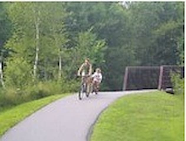
Stowe Recreation Path Peace Park
2699 Mountain RoadStowe Recreation Path is a 10.4 mile moderately trafficked out and back trail located near Stowe, Vermont that features a river and is good for all skill levels. The trail offers a number of activity options and is accessible year-round. Dogs are also able to use this trail but must be kept on leash.
Hiking - Moderate
Mills Riverside Park Loop is a 4.5 mile moderately trafficked loop trail located near Jericho, Vermont that features beautiful wild flowers and is rated as moderate. The trail is primarily used for hiking, running, and mountain biking.
14 Einheimische empfehlen
Mills Riverside park
338 Vermont 15Mills Riverside Park Loop is a 4.5 mile moderately trafficked loop trail located near Jericho, Vermont that features beautiful wild flowers and is rated as moderate. The trail is primarily used for hiking, running, and mountain biking.
Butler Lodge Trail is a 3.6 mile moderately trafficked out and back trail located near Underhill, Vermont and is rated as moderate. The trail is primarily used for hiking and snowshoeing. Dogs are also able to use this trail but must be kept on leash.
Butler Lodge trailhead
Stevensville RoadButler Lodge Trail is a 3.6 mile moderately trafficked out and back trail located near Underhill, Vermont and is rated as moderate. The trail is primarily used for hiking and snowshoeing. Dogs are also able to use this trail but must be kept on leash.
Snake Mountain is a 5.4 mile heavily trafficked loop trail located near Vergennes, Vermont that features beautiful wild flowers and is rated as moderate. The trail is primarily used for hiking and mountain biking and is best used from June until October. Dogs are also able to use this trail but must be kept on leash.
SEASONAL CLOSURE: This area is subject to seasonal closure due to weather conditions. For more information, please visit the Snake Mountain Wildlife Management Area website.
14 Einheimische empfehlen
Snake Mountain Trail
2601 Mountain RdSnake Mountain is a 5.4 mile heavily trafficked loop trail located near Vergennes, Vermont that features beautiful wild flowers and is rated as moderate. The trail is primarily used for hiking and mountain biking and is best used from June until October. Dogs are also able to use this trail but must be kept on leash.
SEASONAL CLOSURE: This area is subject to seasonal closure due to weather conditions. For more information, please visit the Snake Mountain Wildlife Management Area website.
Hiking - Hard
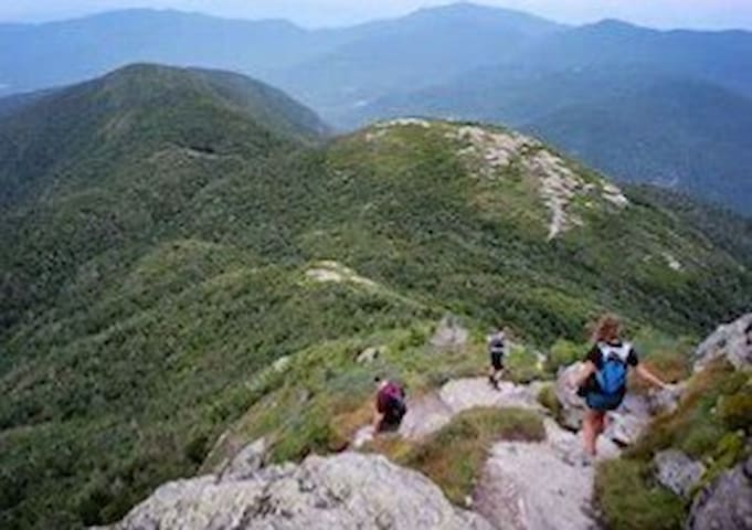
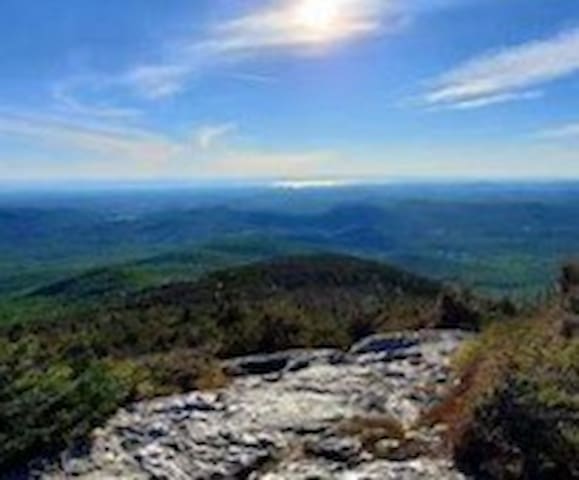
Sunset Ridge and Long Trail Loop is a 5.9 mile heavily trafficked loop trail located near Underhill Center, Vermont that features a waterfall and is rated as difficult. The trail offers a number of activity options and is best used from May until October. Dogs are also able to use this trail but must be kept on leash.
The Sunset Ridge and Long Trail Loop is one of the most popular trails in the Underhill State Park. The Underhill Center and parking lot are right at the trailhead. The Sunset Ridge trail takes you to the highest peak of the park while the Long Trail loops along the ridge back to the trailhead.
It's recommended by park staff to ascend the Halfway House Trail, traverse the Long Trail to the Chin (highest point in Vermont) and then descend Sunset Ridge. Halfway House is a steep trail, especially close to the Long Trail ridge-line, but has numerous switchbacks along the way. The Long Trail is all above the tree line and provides nearly 360 views of Vermont, Adirondacks, & White Mountains, but there's no shelter in bad weather (wind or rain). Sunset Ridge is a more gradual hike down, so it's less difficult heading down Mansfield; it also is above tree line for the top half and provides excellent views of the Champlain Valley and Adirondacks. The trail to the summit can be slippery and spikes are recommended.
Other popular sites in the area are the Green Mountains, Cantilever Rock, and Pleasant Valley.
Halfway and Sunset Ridge have Blue Blazes, while the Long Trail is White. It's best to avoid Yellow blazed trails because they are generally more difficult rock scrambles.
6 Einheimische empfehlen
Sunset Ridge Trail
Sunset Ridge TrailSunset Ridge and Long Trail Loop is a 5.9 mile heavily trafficked loop trail located near Underhill Center, Vermont that features a waterfall and is rated as difficult. The trail offers a number of activity options and is best used from May until October. Dogs are also able to use this trail but must be kept on leash.
The Sunset Ridge and Long Trail Loop is one of the most popular trails in the Underhill State Park. The Underhill Center and parking lot are right at the trailhead. The Sunset Ridge trail takes you to the highest peak of the park while the Long Trail loops along the ridge back to the trailhead.
It's recommended by park staff to ascend the Halfway House Trail, traverse the Long Trail to the Chin (highest point in Vermont) and then descend Sunset Ridge. Halfway House is a steep trail, especially close to the Long Trail ridge-line, but has numerous switchbacks along the way. The Long Trail is all above the tree line and provides nearly 360 views of Vermont, Adirondacks, & White Mountains, but there's no shelter in bad weather (wind or rain). Sunset Ridge is a more gradual hike down, so it's less difficult heading down Mansfield; it also is above tree line for the top half and provides excellent views of the Champlain Valley and Adirondacks. The trail to the summit can be slippery and spikes are recommended.
Other popular sites in the area are the Green Mountains, Cantilever Rock, and Pleasant Valley.
Halfway and Sunset Ridge have Blue Blazes, while the Long Trail is White. It's best to avoid Yellow blazed trails because they are generally more difficult rock scrambles.
The Chin via Long and Profanity Trail
is a 4.9 mile heavily trafficked loop trail located near Stowe, Vermont that features beautiful wild flowers and is rated as difficult. The trail is primarily used for hiking and is best used from May until October. Dogs are also able to use this trail but must be kept on leash.
SEASONAL ROAD CLOSURE: The road on Smugglers' Notch Pass on VT 108 closes seasonally due to winter weather conditions, usually from mid-October through mid-May. For more information, please visit https://www.smuggs.com/pages/winter/directions.php
Parking is near the Stowe Mountain Resort Gondola Ride. Look for the Lower Barnes Lot on Google. When you head into the area, take the first Right. Trail head is across the street. This add some distance to the whole hike.
39 Einheimische empfehlen
Mount Mansfield
The Chin via Long and Profanity Trail
is a 4.9 mile heavily trafficked loop trail located near Stowe, Vermont that features beautiful wild flowers and is rated as difficult. The trail is primarily used for hiking and is best used from May until October. Dogs are also able to use this trail but must be kept on leash.
SEASONAL ROAD CLOSURE: The road on Smugglers' Notch Pass on VT 108 closes seasonally due to winter weather conditions, usually from mid-October through mid-May. For more information, please visit https://www.smuggs.com/pages/winter/directions.php
Parking is near the Stowe Mountain Resort Gondola Ride. Look for the Lower Barnes Lot on Google. When you head into the area, take the first Right. Trail head is across the street. This add some distance to the whole hike.
Mount Mansfield via Hellbrook Trail and the Long Trail
Mount Mansfield via Hellbrook Trail and the Long Trail is a 3.7 mile heavily trafficked loop trail located near Jeffersonville, Vermont that features beautiful wild flowers and is rated as difficult. The trail is primarily used for hiking, nature trips, and bird watching and is best used from April until November.
SEASONAL ROAD CLOSURE: The road on Smugglers' Notch Pass on VT 108 closes seasonally due to winter weather conditions, usually from mid-October through mid-May. For more information, please visit https://www.smuggs.com/pages/winter/directions.php
The Hell Brook trail is a fun and challenging route to 'The Chin' of Mount Mansfield (The Summit). This is the shortest and steepest but also most technically difficult route to the summit.
The trail is mostly large rocks and is usually wet. This route is considerably less busy than the popular Long Trail, which also makes it nice.
39 Einheimische empfehlen
Mount Mansfield
Mount Mansfield via Hellbrook Trail and the Long Trail
Mount Mansfield via Hellbrook Trail and the Long Trail is a 3.7 mile heavily trafficked loop trail located near Jeffersonville, Vermont that features beautiful wild flowers and is rated as difficult. The trail is primarily used for hiking, nature trips, and bird watching and is best used from April until November.
SEASONAL ROAD CLOSURE: The road on Smugglers' Notch Pass on VT 108 closes seasonally due to winter weather conditions, usually from mid-October through mid-May. For more information, please visit https://www.smuggs.com/pages/winter/directions.php
The Hell Brook trail is a fun and challenging route to 'The Chin' of Mount Mansfield (The Summit). This is the shortest and steepest but also most technically difficult route to the summit.
The trail is mostly large rocks and is usually wet. This route is considerably less busy than the popular Long Trail, which also makes it nice.
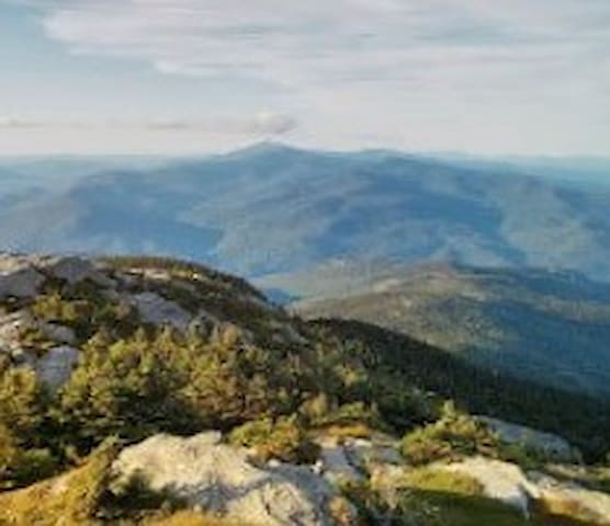
Camel's Hump Trail is a 6 mile heavily trafficked out and back trail located near Waterbury, Vermont that features a waterfall and is rated as difficult. The trail offers a number of activity options and is accessible year-round. Dogs are also able to use this trail but must be kept on leash.
Camel's Hump Trail is one of the best day hiking trails in the Green Mountain National Forest, along with being the third highest peak in the state. The summit offers unbeatable views in every direction, including Killington Peak. The trailhead can be accessed off of Camel’s Hump Road, where there is a small parking area for visitors. Users recommend arriving early in the warmer months and on weekends, since the road is not an option for parking.
This trail can be completed as an out-and-back hike, which is 6 miles round trip via the Monroe Trail, or a loop route via Monroe Trail, Dean Trail, and Long Trail. Alternatively, Camel's Hump can also be reached from the Burrows trailhead via the Forest City Trail to Burrows Trail.
For this out-and-back route, users will start the hike on the Monroe trail which is steep, but does include plenty of leveling off during the hike. From the Monroe Trail users will reach the Dean Trail intersection, at which point users have the option to turn left onto Dean Trail and then take the Long Trail up to the summit or continue straight on the Monroe Trail to the summit. If continuing straight on Monroe Trail, users will reach the hut clearing at which point the Monroe Trail ends and becomes the Long Trail. It is then a short climb to the summit.
The last part of the hike can become very steep and narrow. If afraid of heights this may not be the trail for shaky legs. But, the fear is worth it once reached the summit, as users have a 360 degree view of nearly every mountain range in the area. You will see Mount Mansfield to the north and Mount Washington to the east. On a clear day you can even see Canada!
From the summit, take the Long Trail south back to the Monroe Trail. To enjoy the descent and get a pat on the back!
Camels Hump Road
Camels Hump RoadCamel's Hump Trail is a 6 mile heavily trafficked out and back trail located near Waterbury, Vermont that features a waterfall and is rated as difficult. The trail offers a number of activity options and is accessible year-round. Dogs are also able to use this trail but must be kept on leash.
Camel's Hump Trail is one of the best day hiking trails in the Green Mountain National Forest, along with being the third highest peak in the state. The summit offers unbeatable views in every direction, including Killington Peak. The trailhead can be accessed off of Camel’s Hump Road, where there is a small parking area for visitors. Users recommend arriving early in the warmer months and on weekends, since the road is not an option for parking.
This trail can be completed as an out-and-back hike, which is 6 miles round trip via the Monroe Trail, or a loop route via Monroe Trail, Dean Trail, and Long Trail. Alternatively, Camel's Hump can also be reached from the Burrows trailhead via the Forest City Trail to Burrows Trail.
For this out-and-back route, users will start the hike on the Monroe trail which is steep, but does include plenty of leveling off during the hike. From the Monroe Trail users will reach the Dean Trail intersection, at which point users have the option to turn left onto Dean Trail and then take the Long Trail up to the summit or continue straight on the Monroe Trail to the summit. If continuing straight on Monroe Trail, users will reach the hut clearing at which point the Monroe Trail ends and becomes the Long Trail. It is then a short climb to the summit.
The last part of the hike can become very steep and narrow. If afraid of heights this may not be the trail for shaky legs. But, the fear is worth it once reached the summit, as users have a 360 degree view of nearly every mountain range in the area. You will see Mount Mansfield to the north and Mount Washington to the east. On a clear day you can even see Canada!
From the summit, take the Long Trail south back to the Monroe Trail. To enjoy the descent and get a pat on the back!
The Nose via Haselton Trail is a 4.6 mile moderately trafficked out and back trail located near Stowe, Vermont that features beautiful wild flowers and is rated as difficult. The trail offers a number of activity options and is best used from March until October. Dogs are also able to use this trail but must be kept on leash.
SEASONAL ROAD CLOSURE: The road on Smugglers' Notch Pass on VT 108 closes seasonally due to winter weather conditions, usually from mid-October through mid-May. For more information, please visit https://www.smuggs.com/pages/winter/directions.php
The Nose
The Nose via Haselton Trail is a 4.6 mile moderately trafficked out and back trail located near Stowe, Vermont that features beautiful wild flowers and is rated as difficult. The trail offers a number of activity options and is best used from March until October. Dogs are also able to use this trail but must be kept on leash.
SEASONAL ROAD CLOSURE: The road on Smugglers' Notch Pass on VT 108 closes seasonally due to winter weather conditions, usually from mid-October through mid-May. For more information, please visit https://www.smuggs.com/pages/winter/directions.php
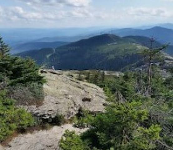
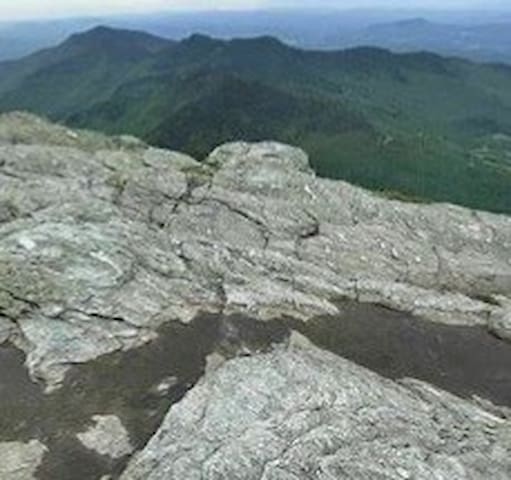
Mount Mansfield Loop Trail is a 7.3 mile heavily trafficked loop trail located near Underhill, Vermont that features beautiful wild flowers and is only recommended for very experienced adventurers. The trail offers a number of activity options and is accessible year-round. Dogs are also able to use this trail but must be kept on leash.
Mount Mansfield is the highest mountain in Vermont and is located in Chittenden County within the Green Mountains. The Mount Mansfield Loop Trail takes you above the tree line. The hike begins at Underhill State Park off of Mountain Road where there is plenty of parking available in the parking lot for a fee of $4/person. Because the park has tent camping, there are bathrooms and potable water available at the trailhead.
The hike starts along CCC Road. You will continue on CCC Road until you reach Maple Ridge Trail. Maple Ridge Trail is the most technical part of the hike. Two parts of the Maple Ridge Trail stand out as scariest. One is a rock wall that has only limited grips and toe holds, and a fall off that wall would cause serious harm. The second part is a chasm about six feet deep that you have to leap over. As with climbing the rock wall, there is no margin for error with this leap. You have to commit and then execute properly. The average adult may find it frightening but will be able to do it safely. Because of these two challenging sections, it is not recommend to attempt this hike in bad weather conditions where the rocks would be wet or icy. You will then reach the Long Trail and continue along the Long Trail north, passing the forehead, the nose and northward along the ridgeline to the Chin. From there, you can extend the trip up to Adams Apple or turn around and begin the descent along the Sunset Ridge Trail.
The is a great hike to Vermont's highest point that boasts spectacular views once you get to the rocky outcrops on the Maple Ridge Trail and will continue to impress on the Long Trail and for most of the descent on the Sunset Ridge Trail. Mount Mansfield is also one of two places in Vermont where Alpine Tundra can be found. Some additional popular options in this area are the Laura Cowles Trail, Lake Champlain, and the Taft Lodge. This is one of the best trails in the state of Vermont.
39 Einheimische empfehlen
Mount Mansfield
Mount Mansfield Loop Trail is a 7.3 mile heavily trafficked loop trail located near Underhill, Vermont that features beautiful wild flowers and is only recommended for very experienced adventurers. The trail offers a number of activity options and is accessible year-round. Dogs are also able to use this trail but must be kept on leash.
Mount Mansfield is the highest mountain in Vermont and is located in Chittenden County within the Green Mountains. The Mount Mansfield Loop Trail takes you above the tree line. The hike begins at Underhill State Park off of Mountain Road where there is plenty of parking available in the parking lot for a fee of $4/person. Because the park has tent camping, there are bathrooms and potable water available at the trailhead.
The hike starts along CCC Road. You will continue on CCC Road until you reach Maple Ridge Trail. Maple Ridge Trail is the most technical part of the hike. Two parts of the Maple Ridge Trail stand out as scariest. One is a rock wall that has only limited grips and toe holds, and a fall off that wall would cause serious harm. The second part is a chasm about six feet deep that you have to leap over. As with climbing the rock wall, there is no margin for error with this leap. You have to commit and then execute properly. The average adult may find it frightening but will be able to do it safely. Because of these two challenging sections, it is not recommend to attempt this hike in bad weather conditions where the rocks would be wet or icy. You will then reach the Long Trail and continue along the Long Trail north, passing the forehead, the nose and northward along the ridgeline to the Chin. From there, you can extend the trip up to Adams Apple or turn around and begin the descent along the Sunset Ridge Trail.
The is a great hike to Vermont's highest point that boasts spectacular views once you get to the rocky outcrops on the Maple Ridge Trail and will continue to impress on the Long Trail and for most of the descent on the Sunset Ridge Trail. Mount Mansfield is also one of two places in Vermont where Alpine Tundra can be found. Some additional popular options in this area are the Laura Cowles Trail, Lake Champlain, and the Taft Lodge. This is one of the best trails in the state of Vermont.