
Ashlee’s - Hiking Trails
Hiking Trails
20ish minutes away... Enjoy a 25-30min hike (at a moderate pace)! Great Trail. One of my favorites!
Buck Mountain
20ish minutes away... Enjoy a 25-30min hike (at a moderate pace)! Great Trail. One of my favorites!
Its about a 25min drive... A shorter hike, with a beautiful view at the top.
75 Einheimische empfehlen
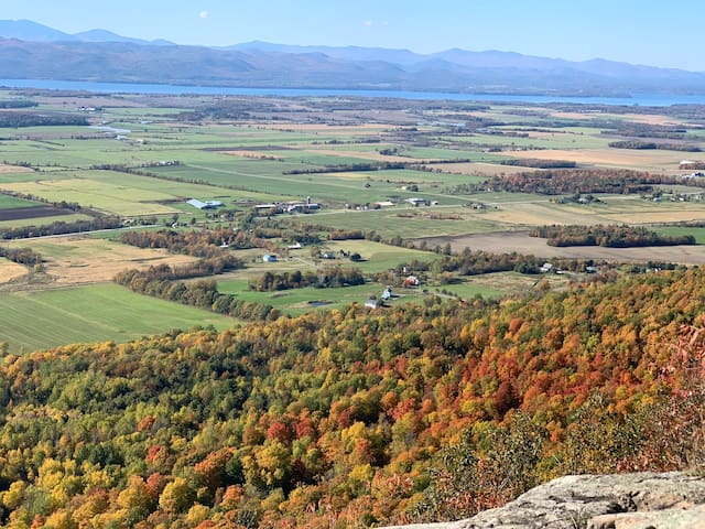
Mt. Philo State Park
5425 Mt Philo RdIts about a 25min drive... A shorter hike, with a beautiful view at the top.
About 20ish minutes away....A great hike! Its's a favorite for many locals. About a 45ish minute hike!
14 Einheimische empfehlen
Snake Mountain Trail
2601 Mountain RdAbout 20ish minutes away....A great hike! Its's a favorite for many locals. About a 45ish minute hike!
38 min away...
Mount Abraham via Battel & Long Trail
5.1 miles...difficult rating.
"For a shorter but equally as challenging summit hike, head to Mount Abraham near Bristol, Vermont. This gorgeous mountain peak trail is very strenuous, with lots of super steep areas and scrambling, but there are incredible views throughout the entire way, especially in the fall. To summit this mountain, scrambling is required, so be ready to use your hands and feet towards the top. Once you get up there, you’ll get a glimpse at one of the most beautiful views in the state of Vermont." The urban Outdoors
33 Einheimische empfehlen
Mount Abraham (Vermont)
38 min away...
Mount Abraham via Battel & Long Trail
5.1 miles...difficult rating.
"For a shorter but equally as challenging summit hike, head to Mount Abraham near Bristol, Vermont. This gorgeous mountain peak trail is very strenuous, with lots of super steep areas and scrambling, but there are incredible views throughout the entire way, especially in the fall. To summit this mountain, scrambling is required, so be ready to use your hands and feet towards the top. Once you get up there, you’ll get a glimpse at one of the most beautiful views in the state of Vermont." The urban Outdoors
39min away
8.1 miles - moderately difficult
"This trail is fun and provides an awesome view at the ski lift. Beautiful trek through the woods with some steep sections, a little brook, and some rock scrambling." alltrails
Jerusalem Trail Trailhead
537 Jim Dwire Rd39min away
8.1 miles - moderately difficult
"This trail is fun and provides an awesome view at the ski lift. Beautiful trek through the woods with some steep sections, a little brook, and some rock scrambling." alltrails
1hr & 12min away...
6 miles - hard
Camel's Hump is one of the best hiking trails in the Green Mountains. It is the third highest peak in the state. The summit offers unbeatable views in every direction. The trail can be accessed off of Camels Hump Road, where there is a small parking area.The last part of the hike can become very steep and narrow. If you are afraid of heights this may not be for you. Once you reach the summit you have a 360 degree view of nearly every mountain range in the area. You will see Mount Mansfield to the north and Mount Washington to the east. On a clear day you can even see Canada." alltrails.com
51 Einheimische empfehlen
Camels Hump
1hr & 12min away...
6 miles - hard
Camel's Hump is one of the best hiking trails in the Green Mountains. It is the third highest peak in the state. The summit offers unbeatable views in every direction. The trail can be accessed off of Camels Hump Road, where there is a small parking area.The last part of the hike can become very steep and narrow. If you are afraid of heights this may not be for you. Once you reach the summit you have a 360 degree view of nearly every mountain range in the area. You will see Mount Mansfield to the north and Mount Washington to the east. On a clear day you can even see Canada." alltrails.com
1hr and 3 min away...
Mount Abraham and Mount Ellen Loop
10 mile loop - hard
"This is a fun ridge climb in winter or spring if you bring along a pair of skis for the descent. Once you climb up the ski slopes you'll be following the Long Trail over the ridge to get both Abraham and Ellen. You'll reach the top of Lincoln Peak first on your ascent above the highest chairlift at Sugarbush. You'll then follow the ridge south to the bare summit of Abraham then back north a long ways across the ridge to the wooded summit of Ellen above Mad River Glen ski resort. Don't go down these trails as you'll end up at the base of the wrong resort. Instead, trace your steps back along the ridge where you intersect the Sugarbush trails. Pick a trail from here, snap into your skis and head on down for a fun descent." alltrails
24 Einheimische empfehlen
Sugarbush Resort at Mt. Ellen
626 Mt Ellen Rd1hr and 3 min away...
Mount Abraham and Mount Ellen Loop
10 mile loop - hard
"This is a fun ridge climb in winter or spring if you bring along a pair of skis for the descent. Once you climb up the ski slopes you'll be following the Long Trail over the ridge to get both Abraham and Ellen. You'll reach the top of Lincoln Peak first on your ascent above the highest chairlift at Sugarbush. You'll then follow the ridge south to the bare summit of Abraham then back north a long ways across the ridge to the wooded summit of Ellen above Mad River Glen ski resort. Don't go down these trails as you'll end up at the base of the wrong resort. Instead, trace your steps back along the ridge where you intersect the Sugarbush trails. Pick a trail from here, snap into your skis and head on down for a fun descent." alltrails
1hr and 16min away
Mount Mansfield Loop
10miles - hard
The is a great hike to Vermont's highest point that boasts spectacular views once you get to the rocky outcrops on the Maple Ridge Trail and will continue to impress on the Long Trail and for most of the descent on the Sunset Ridge Trail. Mount Mansfield is also one of two places in Vermont where Alpine Tundra can be found." alltrails
24 Einheimische empfehlen
Underhill State Park
352 Mountain Rd1hr and 16min away
Mount Mansfield Loop
10miles - hard
The is a great hike to Vermont's highest point that boasts spectacular views once you get to the rocky outcrops on the Maple Ridge Trail and will continue to impress on the Long Trail and for most of the descent on the Sunset Ridge Trail. Mount Mansfield is also one of two places in Vermont where Alpine Tundra can be found." alltrails
50min away...
5.3mi (if you do the entire loop around the lake) - moderate
Wonderful hike - has a spring-fed lake at the top and is very clean.
19 Einheimische empfehlen
Silver Lake Trail
50min away...
5.3mi (if you do the entire loop around the lake) - moderate
Wonderful hike - has a spring-fed lake at the top and is very clean.
1hr 24min
0.4miles - easy
"The Thundering Brook Falls hike is a short, beginner-friendly trail that takes hikers of all experience levels to another one of Vermont’s beautiful and unique waterfalls. This one, Thundering Brook Falls, looks more like a staircase with water cascading down the steps. It’s a totally different scene than the 31-foot drop of Bingham Falls! The trail itself is easy and features a network of wooden boardwalks that take hikers through the forest to the falls. " theurbanoutdoors
49 Einheimische empfehlen
Thundering Brook Falls Trail
2295 River Rd Fork1hr 24min
0.4miles - easy
"The Thundering Brook Falls hike is a short, beginner-friendly trail that takes hikers of all experience levels to another one of Vermont’s beautiful and unique waterfalls. This one, Thundering Brook Falls, looks more like a staircase with water cascading down the steps. It’s a totally different scene than the 31-foot drop of Bingham Falls! The trail itself is easy and features a network of wooden boardwalks that take hikers through the forest to the falls. " theurbanoutdoors
1hr 16min away
3 miles - moderate
"One super cool, quick hike in Underhill State Park is the Cantilever Rock trail, which boasts 3 miles of hiking to get to one of the weirdest rock formations in Vermont. This forested trail traverses dirt paths and wooden bridges to get to a scenic, rocky overlook where the Cantilever Rock sticks precariously out of the side of a cliff. Perhaps equally (or more) beautiful is the rocky summit that greets you at the end of the trail, with breathtaking views of the mountains and surrounding landscape as far as the eye can see." theurbanoutdoors
Cantilever Rock
Sunset Ridge Trail1hr 16min away
3 miles - moderate
"One super cool, quick hike in Underhill State Park is the Cantilever Rock trail, which boasts 3 miles of hiking to get to one of the weirdest rock formations in Vermont. This forested trail traverses dirt paths and wooden bridges to get to a scenic, rocky overlook where the Cantilever Rock sticks precariously out of the side of a cliff. Perhaps equally (or more) beautiful is the rocky summit that greets you at the end of the trail, with breathtaking views of the mountains and surrounding landscape as far as the eye can see." theurbanoutdoors
Sunset Ledge Trail Head
3573 Lincoln Gap Rd44 mins away
1.3 miles - moderate
36 min away...
5miles - moderate
"Duclos Road Loop is a 5 mile lightly trafficked loop trail located near Bristol, Vermont that features a lake and is rated as moderate." alltrails
Duclos Road
Duclos Road36 min away...
5miles - moderate
"Duclos Road Loop is a 5 mile lightly trafficked loop trail located near Bristol, Vermont that features a lake and is rated as moderate." alltrails
1hr and 45min
6.3 miles - hard
"For a leg burner that’ll give you a great workout, Equinox Mountain & Lookout Rock is one of the hardest hikes in Vermont. What makes it so difficult, you ask? The unrelenting uphill climb that takes you from the base of the mountain to the peak, with steepness grades of up to 48% in some areas. It’s definitely best suited for those looking for a “workout” hike rather than one for views and scenery alone, although the views from the top of Manchester and the nearby mountains are quite breathtaking." theurbanoutdoors
69 Einheimische empfehlen
Equinox Mountain
1hr and 45min
6.3 miles - hard
"For a leg burner that’ll give you a great workout, Equinox Mountain & Lookout Rock is one of the hardest hikes in Vermont. What makes it so difficult, you ask? The unrelenting uphill climb that takes you from the base of the mountain to the peak, with steepness grades of up to 48% in some areas. It’s definitely best suited for those looking for a “workout” hike rather than one for views and scenery alone, although the views from the top of Manchester and the nearby mountains are quite breathtaking." theurbanoutdoors
1hr 23min away
7.2 miles - hard
"Hailed as one of Vermont’s most famous skiing peaks, the Killington summit makes for a fantastic hike during the off season. The Bucklin Trail is a local trail that brings hikers to the summit of this well-known mountain. However, unlike many hiking trails that traverse popular ski areas, this one feels remote and forested, with little to no crossroads with the skiing runs. This classic, strenuous Vermont hike begins with a gradual uphill through the woods and tops off with a rock scramble to the summit, which boasts nearly 360 degree views of the area surrounding this famous peak/ski resort. Once you’ve hiked this mountain in the summer or fall, you can come back in the winter and ski it for a double-whammy!" theurbanoutdoors
8 Einheimische empfehlen
Bucklin Trailhead
Wheelerville Road1hr 23min away
7.2 miles - hard
"Hailed as one of Vermont’s most famous skiing peaks, the Killington summit makes for a fantastic hike during the off season. The Bucklin Trail is a local trail that brings hikers to the summit of this well-known mountain. However, unlike many hiking trails that traverse popular ski areas, this one feels remote and forested, with little to no crossroads with the skiing runs. This classic, strenuous Vermont hike begins with a gradual uphill through the woods and tops off with a rock scramble to the summit, which boasts nearly 360 degree views of the area surrounding this famous peak/ski resort. Once you’ve hiked this mountain in the summer or fall, you can come back in the winter and ski it for a double-whammy!" theurbanoutdoors
Appalachian Gap
The Long Trail/Monroe Skyline (Gap to Gap)
12.1 miles - moderate
This trail can also be started from Route 17
39 Einheimische empfehlen
Long Trail
Long TrailThe Long Trail/Monroe Skyline (Gap to Gap)
12.1 miles - moderate
This trail can also be started from Route 17