
GUIDE BOOK
CABIN
We are so excited to share all of the adventures in store for you when you visit Pinetop-Lakeside, Arizona. Sitting at an elevation of 7,000 ft, Pinetop-Lakeside offers clean crisp air, a mesmerizing star-filled sky, miles of trails through the world's largest Ponderosa Pine Forest, and over 200 streams and lakes. This year-around, natural playground provides endless opportunities for all of your favorite outdoor activities from skiing to fishing to hiking.
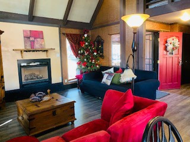
5978 N Whistle Stop Loop
5978 North Whistle Stop LoopWe are so excited to share all of the adventures in store for you when you visit Pinetop-Lakeside, Arizona. Sitting at an elevation of 7,000 ft, Pinetop-Lakeside offers clean crisp air, a mesmerizing star-filled sky, miles of trails through the world's largest Ponderosa Pine Forest, and over 200 streams and lakes. This year-around, natural playground provides endless opportunities for all of your favorite outdoor activities from skiing to fishing to hiking.
LAKES
Much of the land surrounding Rainbow Lake is privately owned, with only a small parcel of land near the dam for public access. It is located within the Pinetop-Lakeside town limits, but has a wide range of fish species including trout, bass, catfish, and some northern pike. Gas-powered boats must be 10 horsepower or less, and boat rentals are available at Rainbow’s End Resort near the lake. The Lakeside Campground can be found near the dam.
45 Einheimische empfehlen
Rainbow Lake
Much of the land surrounding Rainbow Lake is privately owned, with only a small parcel of land near the dam for public access. It is located within the Pinetop-Lakeside town limits, but has a wide range of fish species including trout, bass, catfish, and some northern pike. Gas-powered boats must be 10 horsepower or less, and boat rentals are available at Rainbow’s End Resort near the lake. The Lakeside Campground can be found near the dam.
This very small lake has only 18 acres of water-surface and is located in Pinetop-Lakeside, Arizona. Part of Woodland Lake Park, it closes daily at 8 p.m. There is no camping permitted, but is the ideal place for a family picnic. There are numerous recreational facilities, including a volleyball court, children’s playground, ball fields, and a floating fishing dock. Picnic facilities have covered ramadas, picnic tables, charcoal grills, and restrooms. If you enjoy hiking, close, easy trails provide an opportunity to nature watch.
95 Einheimische empfehlen
Woodland Lake Park
East Woodland Lake RoadThis very small lake has only 18 acres of water-surface and is located in Pinetop-Lakeside, Arizona. Part of Woodland Lake Park, it closes daily at 8 p.m. There is no camping permitted, but is the ideal place for a family picnic. There are numerous recreational facilities, including a volleyball court, children’s playground, ball fields, and a floating fishing dock. Picnic facilities have covered ramadas, picnic tables, charcoal grills, and restrooms. If you enjoy hiking, close, easy trails provide an opportunity to nature watch.
Considered large for a White Mountains lake, Big Lake is one of the more popular with a surface area of 532 acres when full. Trout is plentiful, and there is a store with boat rentals and four campgrounds ringing the lake (both tent and RV spaces). It is located in the Apache-Sitgreaves National Forests, about 26 miles southwest of Eagar, Arizona.
47 Einheimische empfehlen
Big Lake
Considered large for a White Mountains lake, Big Lake is one of the more popular with a surface area of 532 acres when full. Trout is plentiful, and there is a store with boat rentals and four campgrounds ringing the lake (both tent and RV spaces). It is located in the Apache-Sitgreaves National Forests, about 26 miles southwest of Eagar, Arizona.
Located about two miles north of Big Lake, Crescent Lake is at about 9,000 feet elevation, surrounded by lush forests and rolling meadows. With calm wind, it is an ideal place for fly fishing, but boat fishing is also good when trout is the target. There is a concession store on-site offering boat rentals during the season. Boats are limited to 10 horsepower, and camping is prohibited. Big Lake is near enough and offers camping spots for tents and RVs.
Crescent Lake
Located about two miles north of Big Lake, Crescent Lake is at about 9,000 feet elevation, surrounded by lush forests and rolling meadows. With calm wind, it is an ideal place for fly fishing, but boat fishing is also good when trout is the target. There is a concession store on-site offering boat rentals during the season. Boats are limited to 10 horsepower, and camping is prohibited. Big Lake is near enough and offers camping spots for tents and RVs.
A scenic lake located on the Fort Apache Reservation, it is a favorite of photographers. With 260 acres of water surface, the high mountain peaks and thick forest backdrop will leave you in awe. Though approximately 8,200 feet elevation, it is open year-round in spite of cold temperatures and snow-covered grounds. You will enjoy great trout fishing and ice fishing in the winter. About 30 miles east of Show Low, there are cabins for rent and a campground operated strictly under tribal regulations.
25 Einheimische empfehlen
Hawley Lake
A scenic lake located on the Fort Apache Reservation, it is a favorite of photographers. With 260 acres of water surface, the high mountain peaks and thick forest backdrop will leave you in awe. Though approximately 8,200 feet elevation, it is open year-round in spite of cold temperatures and snow-covered grounds. You will enjoy great trout fishing and ice fishing in the winter. About 30 miles east of Show Low, there are cabins for rent and a campground operated strictly under tribal regulations.
At 280 acres and an elevation of more than 9,000 feet, Reservation Lake is one of the most popular in the White Mountains region. Situated 19 miles south of Arizona 260, it is access via Arizona 273 and FS 116. Expect the last nine to be rough in rainy weather. This is a seasonal lake, and only open between April and November. You can fish for rainbow, brook, and brown trout. Shore fishing is better than most lakes, but trolling and fly fishing is better yet. There is a local store, campground, cabin rental, and boat rental.
Reservation Lake
At 280 acres and an elevation of more than 9,000 feet, Reservation Lake is one of the most popular in the White Mountains region. Situated 19 miles south of Arizona 260, it is access via Arizona 273 and FS 116. Expect the last nine to be rough in rainy weather. This is a seasonal lake, and only open between April and November. You can fish for rainbow, brook, and brown trout. Shore fishing is better than most lakes, but trolling and fly fishing is better yet. There is a local store, campground, cabin rental, and boat rental.
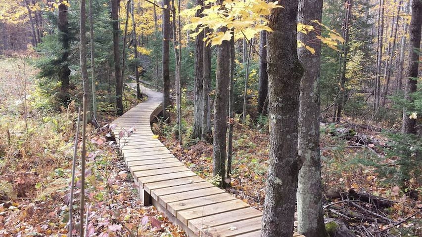
HIKING TRAILS
Distance: 3.25 miles, or 4.25 if you hike the Huff 'n Puff Trail to Pat Mullen Scenic Vista. Difficulty: (as rated by the US Forest Service) Hiking - Moderate Mountain Biking - easy Equestrian - Easy Trailhead Parking: Yes, accommodates trailers. Access to Trail: From the Lakeside Ranger Station, travel south on AZ 260 for 5 miles. Turn left on Bucksprings Road, left on Sky Hi Road (FR 182). The trailhead is 2 miles ahead on the right at the junction of FR 185. Trail Highlights: The trail loops through a Ponderosa Pine forest along Whitcomb Springs Meadow. It follows portions of the old railroad bed used at the turn of the century for transporting timber products. Connector trails head east to Los Burros Trail and south to Springs Trail.
14 Einheimische empfehlen
Country Club Trail #632
Distance: 3.25 miles, or 4.25 if you hike the Huff 'n Puff Trail to Pat Mullen Scenic Vista. Difficulty: (as rated by the US Forest Service) Hiking - Moderate Mountain Biking - easy Equestrian - Easy Trailhead Parking: Yes, accommodates trailers. Access to Trail: From the Lakeside Ranger Station, travel south on AZ 260 for 5 miles. Turn left on Bucksprings Road, left on Sky Hi Road (FR 182). The trailhead is 2 miles ahead on the right at the junction of FR 185. Trail Highlights: The trail loops through a Ponderosa Pine forest along Whitcomb Springs Meadow. It follows portions of the old railroad bed used at the turn of the century for transporting timber products. Connector trails head east to Los Burros Trail and south to Springs Trail.
Distance: 3.6 miles
Difficulty: (as rated by the US Forest Service)
Hiking: Easy
Mountain Biking: Moderate Equestrian: Easy
Trailhead Parking: Limited
Access to Trail: From the Lakeside Ranger Station, travel South on AZ 260 for 5 miles. Turn Left on Bucksprings Rd, then Left again on Sky Hi Road (FR 182).
Continue 1.1 miles to the Trailhead on the Left.
Trail Highlights: The Springs Trail is a cool, refreshing trip along the Billy Creek and Thompson Creek riparian areas. The trail can be extremely muddy
during the spring and monsoon seasons. Connector trails head North to Blue Ridge Trail and East to Country Club Trail. (NOTE: Little Bear Connector leads to Blue Ridge Trail.)
13 Einheimische empfehlen
Springs Trail Trailhead
101 Sky Hi RdDistance: 3.6 miles
Difficulty: (as rated by the US Forest Service)
Hiking: Easy
Mountain Biking: Moderate Equestrian: Easy
Trailhead Parking: Limited
Access to Trail: From the Lakeside Ranger Station, travel South on AZ 260 for 5 miles. Turn Left on Bucksprings Rd, then Left again on Sky Hi Road (FR 182).
Continue 1.1 miles to the Trailhead on the Left.
Trail Highlights: The Springs Trail is a cool, refreshing trip along the Billy Creek and Thompson Creek riparian areas. The trail can be extremely muddy
during the spring and monsoon seasons. Connector trails head North to Blue Ridge Trail and East to Country Club Trail. (NOTE: Little Bear Connector leads to Blue Ridge Trail.)
Distance: 0.75 miles
Difficulty: (as rated by the US Forest Service)
Hiking - Easy Mountain Biking - Easy Equestrian - Easy
Trailhead Parking: Limited, vehicles only
Access to Trail: From the Lakeside Ranger Station, travel south on AZ 260 for 2.4 miles. Turn left on Pinecrest Rd and go a short distance to end of the road where
there is limited parking. The kiosk is a few yards from the gate.
Trail Highlights: The trail winds along Billy Creek for about a quarter of a mile and connects with the Blue Ridge Trail at its Southeast corner.
9 Einheimische empfehlen
Billy Creek Trailhead
Distance: 0.75 miles
Difficulty: (as rated by the US Forest Service)
Hiking - Easy Mountain Biking - Easy Equestrian - Easy
Trailhead Parking: Limited, vehicles only
Access to Trail: From the Lakeside Ranger Station, travel south on AZ 260 for 2.4 miles. Turn left on Pinecrest Rd and go a short distance to end of the road where
there is limited parking. The kiosk is a few yards from the gate.
Trail Highlights: The trail winds along Billy Creek for about a quarter of a mile and connects with the Blue Ridge Trail at its Southeast corner.
Distance: 3 miles around Hitching Posts Loop Trail and back to boat dock. 0l5 Mile to Turkey Track Trail. 0.75 miles to Pinecrest Trail. 1.5 miles to Big
Springs Trail. l mile around Lake Loop Trail. 2.0 miles along the Hitching Post Loop trail. There is horse access to the Hitching Post Trail along the Western side of the lake.
Difficulty: (as rated by the US Forest Service)
Hiking - Easy Mountain Biking - Easy Equestrian - Easy
Trailhead Parking: Parking at lot off of Woodland Rd and at the fishing dock and ramadas.
Access to Trail: From the traffic light on AZ 260 at Pinetop-Lakeside Plaza, go south (Toward McNary) 1.2 miles. Turn right on Woodland Rd and go 0.3 miles
to the first entrance (the ramadas and boat dock) or go 0.4 miles to the second entrance (the ball fields and tennis courts).
Trail Highlights: A rural treasure within city limits, the trails offer something for almost everyone. A paved ADA-designed trail, ideal for strollers, wheelchairs,
etc. winds around the lake. Hike, bike or ride a horse along the rugged and beautiful trails.
95 Einheimische empfehlen
Woodland Lake Park
East Woodland Lake RoadDistance: 3 miles around Hitching Posts Loop Trail and back to boat dock. 0l5 Mile to Turkey Track Trail. 0.75 miles to Pinecrest Trail. 1.5 miles to Big
Springs Trail. l mile around Lake Loop Trail. 2.0 miles along the Hitching Post Loop trail. There is horse access to the Hitching Post Trail along the Western side of the lake.
Difficulty: (as rated by the US Forest Service)
Hiking - Easy Mountain Biking - Easy Equestrian - Easy
Trailhead Parking: Parking at lot off of Woodland Rd and at the fishing dock and ramadas.
Access to Trail: From the traffic light on AZ 260 at Pinetop-Lakeside Plaza, go south (Toward McNary) 1.2 miles. Turn right on Woodland Rd and go 0.3 miles
to the first entrance (the ramadas and boat dock) or go 0.4 miles to the second entrance (the ball fields and tennis courts).
Trail Highlights: A rural treasure within city limits, the trails offer something for almost everyone. A paved ADA-designed trail, ideal for strollers, wheelchairs,
etc. winds around the lake. Hike, bike or ride a horse along the rugged and beautiful trails.
Old Hatchery Trail
Distance: .8 miles
Difficulty: Hiking: Moderate Biking: Difficult
Equestrian: Easy
Trailhead Parking: Parking at Game and Fish. No equestrians at this location.
Access to Trail: From the Lakeside Ranger Station, travel South on AZ 260 for 4.5 miles. Turn Left at the sign for Arizona Game and Fish. The trail begins just
past the Game and Fish office.
Trail Highlights: The Old Hatchery Trail goes past the old fish hatchery. Just before descending to Billy Creek, there is a short side trail that leads to
highway 260. The portion of the trail from Game and Fish, to this point is open to hikers only. There is a bridge crossing Billy Creek, before the trail sharply ascends. It travels along Billy Creek until it dead ends into the Springs Trail.
Ranger Station
Old Hatchery Trail
Distance: .8 miles
Difficulty: Hiking: Moderate Biking: Difficult
Equestrian: Easy
Trailhead Parking: Parking at Game and Fish. No equestrians at this location.
Access to Trail: From the Lakeside Ranger Station, travel South on AZ 260 for 4.5 miles. Turn Left at the sign for Arizona Game and Fish. The trail begins just
past the Game and Fish office.
Trail Highlights: The Old Hatchery Trail goes past the old fish hatchery. Just before descending to Billy Creek, there is a short side trail that leads to
highway 260. The portion of the trail from Game and Fish, to this point is open to hikers only. There is a bridge crossing Billy Creek, before the trail sharply ascends. It travels along Billy Creek until it dead ends into the Springs Trail.
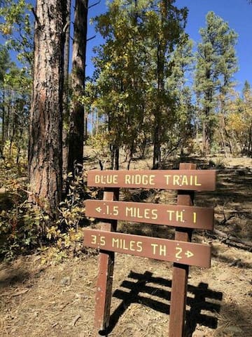
Blue Ridge Trail #107A
Distance: 9.4 miles
Difficulty: (as rated by the US Forest Service)
Hiking - Moderate Mountain Biking - Difficult Equestrian - Moderate
Trailhead Parking: Yes. Accommodates trailers
Access to Trail: From the Lakeside Ranger Station, travel south on AZ 260 5 miles. Turn left on Bucksprings Rd, then left again on Sky Hi Rd (FR182) and left on
FR 187 to Trailhead #2. Continue on FR 187 to Trailhead #1. Or you can access Trailhead #1 from AZ 260: turn North on Moonridge, right on Billy Creek, left on Meadow to cross the bridge, right on Pine Shadow, go around the curve to the left then right on FR 187 for about .8 mile to Trailhead #1 on your right.
Trail Highlights: The trail follows Billy Creek and winds through a ponderosa pine forest to the top of Blue Ridge Mountain. The mountain is volcanic in origin and its
summit offers scenic vistas. Connector trails head southeast to Springs Trail and northwest to Ice Cave Trail
Ranger Station
Blue Ridge Trail #107A
Distance: 9.4 miles
Difficulty: (as rated by the US Forest Service)
Hiking - Moderate Mountain Biking - Difficult Equestrian - Moderate
Trailhead Parking: Yes. Accommodates trailers
Access to Trail: From the Lakeside Ranger Station, travel south on AZ 260 5 miles. Turn left on Bucksprings Rd, then left again on Sky Hi Rd (FR182) and left on
FR 187 to Trailhead #2. Continue on FR 187 to Trailhead #1. Or you can access Trailhead #1 from AZ 260: turn North on Moonridge, right on Billy Creek, left on Meadow to cross the bridge, right on Pine Shadow, go around the curve to the left then right on FR 187 for about .8 mile to Trailhead #1 on your right.
Trail Highlights: The trail follows Billy Creek and winds through a ponderosa pine forest to the top of Blue Ridge Mountain. The mountain is volcanic in origin and its
summit offers scenic vistas. Connector trails head southeast to Springs Trail and northwest to Ice Cave Trail
Distance: 7.5 miles
Difficulty: (as rated by the US Forest Service)
Hiking - Moderate Mountain Biking - Difficult Equestrian - Moderate
Trailhead Parking: Yes, accommodates trailers
Access to Trail: From the Lakeside Ranger Station, travel south on AZ 260 for 0.1 mile. Turn on Porter Mountain Rd. (FR 45) for 2.2 miles, then right at the
junction with Penrod Rd, and continue to the trailhead on the left.
Trail Highlights: This trail has been rerouted into scenic areas. The right half of the old trail remains and continues off to the right through forested areas. The
reroute is about 2 miles longer than the old Timer Mesa Trail. Two connector trails head east to Panorama Trail, and the Osprey Connector heads south to the Ice Cave Trail.
Timber Mesa Fire Road
Timber Mesa Fire RoadDistance: 7.5 miles
Difficulty: (as rated by the US Forest Service)
Hiking - Moderate Mountain Biking - Difficult Equestrian - Moderate
Trailhead Parking: Yes, accommodates trailers
Access to Trail: From the Lakeside Ranger Station, travel south on AZ 260 for 0.1 mile. Turn on Porter Mountain Rd. (FR 45) for 2.2 miles, then right at the
junction with Penrod Rd, and continue to the trailhead on the left.
Trail Highlights: This trail has been rerouted into scenic areas. The right half of the old trail remains and continues off to the right through forested areas. The
reroute is about 2 miles longer than the old Timer Mesa Trail. Two connector trails head east to Panorama Trail, and the Osprey Connector heads south to the Ice Cave Trail.
HORSEBACK RIDING
Your family’s day in the mountains will be made all the more spectacular when you take a short, half-day, or all-day ride over the river and through the woods of the cool-weather White Mountains. Bring your own, or rent a gentle ride from one of our local equestrian facilities.
Horses aren’t just for summers! Nothing compares to a wintry sleigh ride as you and your family are bundled under a stack of blankets and a powerful team of horses pulls you through the snow. Simply the most-romantic evening ever!
15 Einheimische empfehlen
Pinetop Lakes Equestrian Center
5475 Buck Springs RdYour family’s day in the mountains will be made all the more spectacular when you take a short, half-day, or all-day ride over the river and through the woods of the cool-weather White Mountains. Bring your own, or rent a gentle ride from one of our local equestrian facilities.
Horses aren’t just for summers! Nothing compares to a wintry sleigh ride as you and your family are bundled under a stack of blankets and a powerful team of horses pulls you through the snow. Simply the most-romantic evening ever!
GOLFING
Pinetop Lakes Golf & Country Club is an 18-hole executive golf course that is not your typical executive. It boasts 5 par-4's and 2 par-5's with the rest being par 3's that are no sure thing. The total yardage is 4,558 from the tips. All the holes are lined on each side with beautiful tall pines, gorgeous homes and of course out of bounds. Keep your drivers in check and here we go.
8 Einheimische empfehlen
Pinetop Country Club
6734 Country Club DrPinetop Lakes Golf & Country Club is an 18-hole executive golf course that is not your typical executive. It boasts 5 par-4's and 2 par-5's with the rest being par 3's that are no sure thing. The total yardage is 4,558 from the tips. All the holes are lined on each side with beautiful tall pines, gorgeous homes and of course out of bounds. Keep your drivers in check and here we go.
MOTORIZED TRAIL RIDING
The Maverick Trail is a motorized vehicle trail used by off-road motorcycles, all-terrain vehicles (ATVs), and off-highway vehicles (OHVs) in the summer and snowmobiles and OHVs in the winter. Roughly 60 miles in length, the trail opened between Clay Springs and Pinetop-Lakeside in 2010. For the most part, it is rugged and hard-packed terrain.
The Maverick Trail has five trailheads:
Burton
Clay Springs
Panorama Trailhead
Sky-Hi
Timber Mesa
Trailheads provide a staging area and direct access to gated trails, most of which are limited to machines less than 50 inches in width, though some trails can accommodate machines as wide as 60 inches.

Maverick Drive
Maverick DriveThe Maverick Trail is a motorized vehicle trail used by off-road motorcycles, all-terrain vehicles (ATVs), and off-highway vehicles (OHVs) in the summer and snowmobiles and OHVs in the winter. Roughly 60 miles in length, the trail opened between Clay Springs and Pinetop-Lakeside in 2010. For the most part, it is rugged and hard-packed terrain.
The Maverick Trail has five trailheads:
Burton
Clay Springs
Panorama Trailhead
Sky-Hi
Timber Mesa
Trailheads provide a staging area and direct access to gated trails, most of which are limited to machines less than 50 inches in width, though some trails can accommodate machines as wide as 60 inches.
SKIING & SNOWBOARDING
In the heart of Arizona's magnificent White Mountains, Sunrise Park Resort is a recreational paradise offering a wide range of fun and excitement. In winter, three mountains offer some of the finest skiing in the Western United States. With 65 runs, there's an adventure for skiers of any level. There is also a separate snowboarding area, cross country ski trails and a special children's "ski-wee" area. During the summer, enjoy cool temperatures and outdoor adventure that includes scenic lift rides, zip-line tours, downhill mountain biking, nature hikes, tubing slide, airbag jump, archery course, disc golf, water sports and horseback tours.
194 Einheimische empfehlen
Sunrise Park Resort
200 Highway 273In the heart of Arizona's magnificent White Mountains, Sunrise Park Resort is a recreational paradise offering a wide range of fun and excitement. In winter, three mountains offer some of the finest skiing in the Western United States. With 65 runs, there's an adventure for skiers of any level. There is also a separate snowboarding area, cross country ski trails and a special children's "ski-wee" area. During the summer, enjoy cool temperatures and outdoor adventure that includes scenic lift rides, zip-line tours, downhill mountain biking, nature hikes, tubing slide, airbag jump, archery course, disc golf, water sports and horseback tours.